1970s Maps of Boone County, Arkansas
Explore 5 historic maps of Boone County from the 1970s. These maps offer a rare glimpse into what life looked like during the 1970s — showing old roads, neighborhoods, homes, and landmarks that have changed or disappeared over time.
Whether you're researching your family's past, planning a metal detecting trip, or studying how Boone County's landscape evolved across the 1970s, these high-resolution maps are a powerful tool for exploring the history of this region.
- Focus on a specific era: All maps on this page are from the 1970s, giving you a focused view of this time period.
- See what’s changed: Compare century-old streets, trails, and buildings to today's modern landscape using overlays and satellite layers.
- Research with precision: Use these maps for genealogy, historical research, land use analysis, or educational projects.
- View, download, or print: Maps are fully viewable online in high resolution, and can be downloaded or printed for your own records.
Start exploring Boone County's history through authentic maps from the 1970s. This is your window into the past.
Boone County, AR maps
(5)- 1972 Map of Alpena, 1973 Print
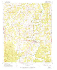 1972 Alpena1973 Print · USGSCrossing the line between Carroll and Boone counties in the early seventies, this map captures the rural network of the Alpena area. Genealogists can locate family burial grounds like McCracken Cem and Riddle Cem, or trace the path of the OLD RAILROAD GRADE.
 - 1972 Map of Denver, 1973 Print
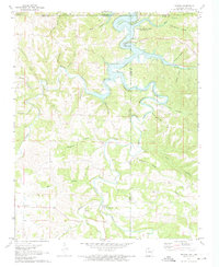 1972 Denver1973 Print · USGSThe Missouri-Arkansas border region is captured here in the early seventies as the reservoir waters of Table Rock Lake submerged the lower creek valleys. Genealogists and local historians can trace family roots through Denver Cem, the settlement of Farewell, and the steep terrain of Backbone Bluff.
 - 1972 Map of Diamond City, 1973 Print
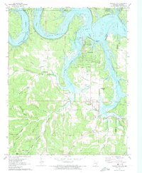 1972 Diamond City1973 Print · USGSDiamond City and Lead Hill sat at the edge of the rising Bull Shoals Lake in the early seventies as the local economy transitioned to recreation. Genealogists can locate numerous rural family burial sites like Pickard Cem or Raley Cem and trace the original Lead Mine workings.
 - 1972 Map of Zinc, 1973 Print
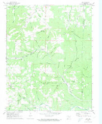 1972 Zinc1973 Print · USGSBoone and Marion counties in the early 1970s reveal a landscape of hollows and ridges shaped by the Missouri Pacific railroad. Genealogists and historians can trace the community of Zinc, early church sites like White Oak Ch, and old mining operations including the Jackpot Mine.
 - 1972 Map of Peel, 1973 Print
 1972 Peel1973 Print · USGSThe Marion County shoreline and the Arkansas-Missouri state line are captured here in the early seventies as the reservoir era reshaped the White River valley. Trace historical family sites and local landmarks like Peel Ferry, Keesee Cem, and the old Lead Mine.2 unique versions available
End of results
Showing maps 1-5 of 5
Top cities of Boone County
- Harrison historical maps
- Diamond City historical maps
- Bellefonte historical maps
- Bergman historical maps
- Lead Hill historical maps
- Everton historical maps
See more
Frequently asked questions
- What are the different types of historical maps available for Boone County?
- What is the oldest map of Boone County?
- Where can I purchase historical maps of Boone County for my home or office?
- Where can I download high-res historical maps of Boone County?
- Are there historical topographic maps available for Boone County?
- Is there historical aerial imagery available for Boone County?
- Where are historical maps of Boone County sourced from?