1930s Maps of Chicot County, Arkansas
Explore 8 historic maps of Chicot County from the 1930s. These maps offer a rare glimpse into what life looked like during the 1930s — showing old roads, neighborhoods, homes, and landmarks that have changed or disappeared over time.
Whether you're researching your family's past, planning a metal detecting trip, or studying how Chicot County's landscape evolved across the 1930s, these high-resolution maps are a powerful tool for exploring the history of this region.
- Focus on a specific era: All maps on this page are from the 1930s, giving you a focused view of this time period.
- See what’s changed: Compare century-old streets, trails, and buildings to today's modern landscape using overlays and satellite layers.
- Research with precision: Use these maps for genealogy, historical research, land use analysis, or educational projects.
- View, download, or print: Maps are fully viewable online in high resolution, and can be downloaded or printed for your own records.
Start exploring Chicot County's history through authentic maps from the 1930s. This is your window into the past.
Chicot County, AR maps
(8)- 1933 Map of Lamont
 1933 Lamont1933 Print · USGSThe Mississippi River delta in the early 1930s is captured here just after the historic floods of the previous decade. Genealogists and historians can trace the foundations of Arkansas City, locate rural sites like Eutaw Store, and follow the tracks of the Mo Pac RR.
 - 1936 Map of McGehee, 1937 Print
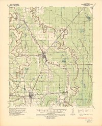 1936 McGehee1937 Print · USGSThe Arkansas Delta during the mid-thirties comes into focus through its dense network of bayous, rail junctions, and river towns. Genealogists and historians can trace the foundations of Mcgehee and Dermott, while locating rural landmarks like Loggy Bayou Church and the ancient INDIAN MOUNDS.
 - 1936 Map of Eudora, 1943 Print
 1936 Eudora1943 Print · USGSSoutheast Arkansas and northeast Louisiana are captured here in the mid-1930s, showing a landscape shaped by water management and rail transport. Researchers can trace the early energy infrastructure of the Standard Oil Pipe Line or locate rural landmarks like Holly Ridge Ch and Empire.
 - 1936 Map of Lake Village, 1949 Print
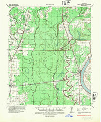 1936 Lake Village1949 Print · USGSThe Arkansas Delta in the mid-1930s is defined by its winding waterways and the rise of the Missouri Pacific railroad. Genealogists and historians can trace old settlements like Jerome, Montrose, and Hudspeth along the shores of Chicot Lake.2 unique versions available
 - 1937 Map of McGehee, 1952 Print
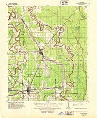 1937 McGehee1952 Print · USGSThe Arkansas Delta comes alive in the late 1930s as a complex network of bayous and rail lines. Genealogists and historians can trace the foundations of McGehee and Dermott, or locate rural landmarks like Providence Church and the Indian Mounds.
 - 1939 Map of Readland, 1942 Print
 1939 Readland1942 Print · USGSThe tri-state delta country comes alive in this late Depression-era survey of the Mississippi riverfront. Genealogists and historians can trace numerous rural congregations and landings, from the Graymound Cem to Lakeport Ldg and Daniels Chapel Shiloh Ch.3 unique versions available
 - 1939 Map of Refuge, 1949 Print
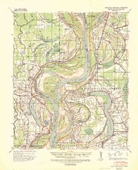
 1939 Refuge1949 Print · USGSThe Mississippi River delta in the late thirties reveals a landscape shaped by massive engineering projects and traditional river life. Trace the shifting banks and cutoff channels alongside rural settlements like Refuge, the rails of the Yazoo and Mississippi Valley Railroad, and local landmarks like Macedonia Ch.4 unique versions available
 - 1939 Map of Lamont, 1961 Print
 1939 Lamont1961 Print · USGSThe Mississippi Delta in the late thirties reveals a landscape in transition as engineering cut-offs reshaped the river's path. Researchers can locate vanished landings like Monterey Ldg, trace the Yazoo and Mississippi Valley rail line, and find rural centers like Morning Star Ch & Sch.3 unique versions available
End of results
Showing maps 1-8 of 8
Top cities of Chicot County
Frequently asked questions
- What are the different types of historical maps available for Chicot County?
- What is the oldest map of Chicot County?
- Where can I purchase historical maps of Chicot County for my home or office?
- Where can I download high-res historical maps of Chicot County?
- Are there historical topographic maps available for Chicot County?
- Is there historical aerial imagery available for Chicot County?
- Where are historical maps of Chicot County sourced from?