1970s Maps of Chicot County, Arkansas
Explore 16 historic maps of Chicot County from the 1970s. These maps offer a rare glimpse into what life looked like during the 1970s — showing old roads, neighborhoods, homes, and landmarks that have changed or disappeared over time.
Whether you're researching your family's past, planning a metal detecting trip, or studying how Chicot County's landscape evolved across the 1970s, these high-resolution maps are a powerful tool for exploring the history of this region.
- Focus on a specific era: All maps on this page are from the 1970s, giving you a focused view of this time period.
- See what’s changed: Compare century-old streets, trails, and buildings to today's modern landscape using overlays and satellite layers.
- Research with precision: Use these maps for genealogy, historical research, land use analysis, or educational projects.
- View, download, or print: Maps are fully viewable online in high resolution, and can be downloaded or printed for your own records.
Start exploring Chicot County's history through authentic maps from the 1970s. This is your window into the past.
Chicot County, AR maps
(16)- 1970 Map of Luna, 1971 Print
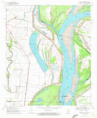
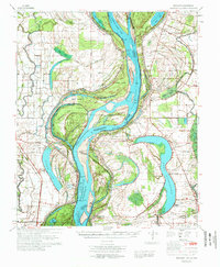
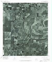
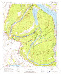 1970 Luna1971 Print · USGSThe Arkansas-Mississippi border country along the great river bends comes to life in the early 1970s. Trace the history of river commerce and flood control through local sites like Gaines Landing, the Panther Forest Crevasse, and Luna Landing.2 unique versions available
 - 1970 Map of Glen Allan, 1972 Print
 1970 Glen Allan1972 Print · USGSThe Mississippi Delta in the early seventies reveals a landscape defined by massive oxbow lakes and river bends. Genealogists and local historians can trace family roots through sites like Glen Allan, Magnolia Ch Cem, and the ancient Indian Mounds near the wildlife refuge.
 - 1970 Map of Greenville, 1972 Print
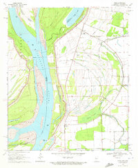
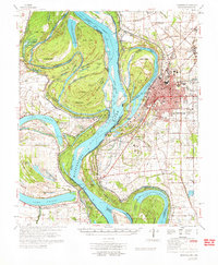
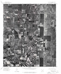
 1970 Greenville1972 Print · USGSGreenville and the Mississippi River frontline are captured here in the early seventies, showing a landscape shaped by massive river cutoffs. Genealogists can locate family landmarks like Old Mt Tabor Cem, Macedonia Ch, and Winterville.2 unique versions available
 - 1970 Map of Wayside, 1972 Print
 1970 Wayside1972 Print · USGSThe Mississippi Delta riverfront south of Greenville appears here in the early seventies, defined by oxbows and rural church communities. Genealogists and historians can trace family locations near Lakeview Gardens Cem, Wayside, and The Old Evening Star Ch.
 - 1970 Map of Readland, 1972 Print
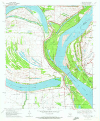
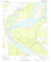
 1970 Readland1972 Print · USGSThe tri-state river country of the Arkansas-Louisiana-Mississippi border comes into focus in this early 1970s survey. Researchers can trace the Missouri Pacific tracks past the Rising Sun Ch or locate family roots in the settlements of Readland and Arkla.
 - 1970 Map of Avon, 1972 Print
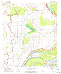
 1970 Avon1972 Print · USGSThe tri-state border region of Mississippi, Arkansas, and Louisiana comes alive in the early seventies as the river meanders through a landscape of levees and oxbows. Researchers can trace rural life at Avon and Longwood or locate the Little Sister Ch Cem.
 - 1970 Map of Red Leaf, 1972 Print
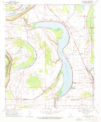
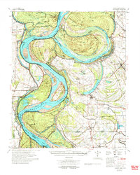
 1970 Red Leaf1972 Print · USGSThe Arkansas riverlands near the Mississippi border appear in the early 1970s, defined by the winding waters of Lake Chicot and Stuart Island. Genealogists and historians can locate rural landmarks like Red Leaf Cem, Jerusalem Ch, and the settlement of Vaucluse.2 unique versions available
 - 1970 Map of Eminence, 1972 Print
 1970 Eminence1972 Print · USGSSoutheast Arkansas in the early seventies reveals a landscape of delta bayous and river chutes. Genealogists and historians can trace local family landmarks like North Star Cem, find the Indian Mounds near Harwood, and locate the historic settlement of Eminence.2 unique versions available
 - 1972 Map of Readland
 1972 Readland1972 Print · USGSThe Arkansas and Mississippi borderlands come to life in the early seventies, showcasing a landscape of massive oxbow lakes and massive river cutoffs. Researchers can locate family landmarks such as Little Sister Ch, Lakeport Cem, and the Indian Mounds near Harwood.
 - 1972 Map of Greenville
 1972 Greenville1972 Print · USGSThe Mississippi Delta's winding riverbanks and fertile lowlands are captured here in the early seventies, detailing the region's complex water management and rural settlements. Genealogists can locate family-named landmarks like The Old Evening Star Ch, Trigg Sch, and the Red Leaf Cem across the Washington County landscape.
 - 1972 Map of Arkansas City, 1974 Print
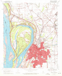
 1972 Arkansas City1974 Print · USGSArkansas City and the surrounding delta are captured here in the early 1970s as the river boundary shifted through old oxbows and new channels. Researchers can trace the Old Railroad Grade and locate local landmarks like Mount Zion Ch, Mound Cem, and the riverfront at Mound Landing.
 - 1975 Map of Lake Village NW, 1976 Print
 1975 Lake Village NW1976 Print · USGSIn the Arkansas Delta during the mid-seventies, the landscape was a complex mosaic of cultivated fields and winding waterways. Researchers can trace the meandering path of Bartholomew Bayou and the small settlement of Jerome amidst the region's productive agricultural grid.
 - 1975 Map of Mc Gehee SW, 1976 Print
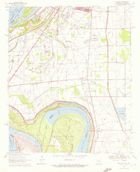
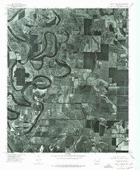
 1975 Mc Gehee SW1976 Print · USGSSoutheast Arkansas farmland and the winding river bends near Dermott are captured in this mid-seventies aerial survey. Genealogists and local historians can trace the street layouts of Mc Gehee and find the rural locations of Masonville and Baxter.
 - 1975 Map of Lake Village NE, 1976 Print
 1975 Lake Village NE1976 Print · USGSSoutheast Arkansas farmland meets the winding Bayou Macon in the mid-seventies, showing the region's transition into intensive large-scale agriculture. Researchers can pinpoint rural intersections and land use patterns near MACON LAKE and Mc Millan Corner.
 - 1975 Map of Mc Gehee SE, 1976 Print
 1975 Mc Gehee SE1976 Print · USGSSoutheast Desha County is shown in the mid-1970s through this aerial orthophoto, revealing the deep-delta agricultural patterns of the Arkansas landscape. Genealogists and local historians can trace the rural layout around Mc Gehee, Halley, and the junctions of the regional transport network.
 - 1977 Map of Lamont
 1977 Lamont1977 Print · USGSThe Mississippi Delta's shifting riverbanks and rural settlements are captured here in the late seventies. Genealogists and historians can trace community landmarks like Williams Chapel, the Nugent Center Sch, and the winding Lake Whittington oxbow.2 unique versions available
End of results
Showing maps 1-16 of 16
Top cities of Chicot County
Frequently asked questions
- What are the different types of historical maps available for Chicot County?
- What is the oldest map of Chicot County?
- Where can I purchase historical maps of Chicot County for my home or office?
- Where can I download high-res historical maps of Chicot County?
- Are there historical topographic maps available for Chicot County?
- Is there historical aerial imagery available for Chicot County?
- Where are historical maps of Chicot County sourced from?