1960s Maps of Crawford County, Arkansas
Explore 10 historic maps of Crawford County from the 1960s. These maps offer a rare glimpse into what life looked like during the 1960s — showing old roads, neighborhoods, homes, and landmarks that have changed or disappeared over time.
Whether you're researching your family's past, planning a metal detecting trip, or studying how Crawford County's landscape evolved across the 1960s, these high-resolution maps are a powerful tool for exploring the history of this region.
- Focus on a specific era: All maps on this page are from the 1960s, giving you a focused view of this time period.
- See what’s changed: Compare century-old streets, trails, and buildings to today's modern landscape using overlays and satellite layers.
- Research with precision: Use these maps for genealogy, historical research, land use analysis, or educational projects.
- View, download, or print: Maps are fully viewable online in high resolution, and can be downloaded or printed for your own records.
Start exploring Crawford County's history through authentic maps from the 1960s. This is your window into the past.
Crawford County, AR maps
(10)- 1964 Map of Russellville
 1964 Russellville1964 Print · USGSMid-century Central Arkansas is defined here by the river-valley towns and the surrounding mountain ranges before the full expansion of the interstate system. Genealogists and historians can trace rail-town development along the Missouri Pacific Railroad and locate landmarks like Arkansas Polytechnic College or Petit Jean State Park.
 - 1965 Map of Fort Smith
 1965 Fort Smith1965 Print · USGSEastern Oklahoma and Western Arkansas are captured here during a period of massive post-war change as new reservoirs reshaped the river valleys. Genealogists and historians can trace the rail networks of the Midland Valley RR and find established communities like Stilwell, Sallisaw, and Stigler.
 - 1967 Map of Fort Smith
 1967 Fort Smith1967 Print · USGSThe Arkansas River valley and the foothills of the Ozarks are captured here during a period of significant military and industrial activity. Researchers can trace the sprawling bounds of Camp Chaffee and Camp Gruber or locate vanished rail stops along the Midland Valley RR.
 - 1969 Map of Uniontown, 1971 Print
 1969 Uniontown1971 Print · USGSThe Arkansas-Oklahoma state line and the Old Indian Treaty Boundary intersect in this 1960s survey of the Ozark foothills. Researchers can trace historic family burial sites like Spears Cem and Woods Cem or locate rural landmarks such as Dripping Springs and Barcelona.3 unique versions available
 - 1969 Map of Natural Dam, 1971 Print
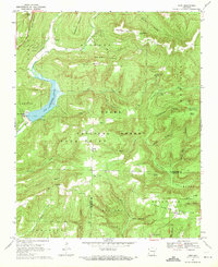
 1969 Natural Dam1971 Print · USGSThe Arkansas-Oklahoma borderlands in the Ozarks appear here as a landscape of remote mountain ridges and creek-side settlements during the late sixties. You can trace old family burial grounds like Bateman Cem and Morton Cem or locate rural landmarks like Peaceful Home Ch and the Lookout Tower.3 unique versions available
 - 1969 Map of Mountainburg SW, 1971 Print
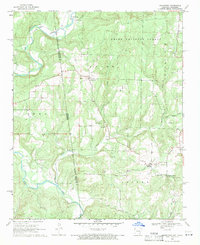
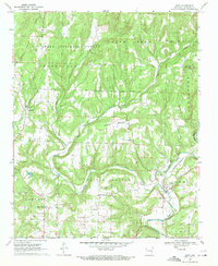
 1969 Mountainburg SW1971 Print · USGSCrawford County settlements and the Ozark foothills are captured here in the late sixties as traditional rail-side communities began to modernize. Researchers can locate numerous family burial grounds including Hatfield Cem and Bolton Cem or trace the early development of Lake Alma.4 unique versions available
 - 1969 Map of Fern, 1971 Print
 1969 Fern1971 Print · USGSCrawford and Franklin counties are shown here in the late sixties as the Ozark interior balanced rural life with forest management. Genealogists can locate family landmarks like Locke Cemetery, the settlement of Fern, and the Faith Church near the Mulberry River.3 unique versions available
 - 1969 Map of Rudy, 1971 Print
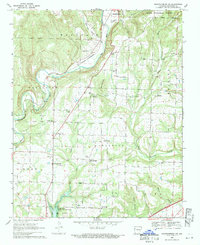
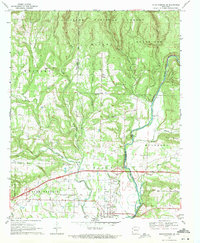
 1969 Rudy1971 Print · USGSCrawford County's rural landscape is captured here in the late sixties as the rail-and-river economy centered on Rudy remained firmly in place. Genealogists can trace family histories through a high density of rural burial sites and meeting houses, including Sarah Grove Cem, McCurry Cem, and Oliver Springs Ch.4 unique versions available
 - 1969 Map of Mountainburg, 1971 Print
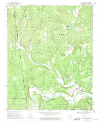
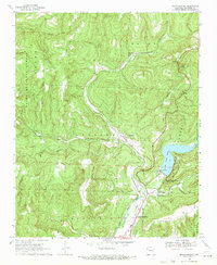 1969 Mountainburg1971 Print · USGSCrawford County in the late sixties reveals a landscape shaped by the Ozark timberlands and the crucial water management of Lake Fort Smith. Researchers can trace the St Louis-San Francisco rail line through rural settlements like Chester and find local landmarks such as Freedom Ch.3 unique versions available
 - 1969 Map of Mountainburg SE, 1971 Print
 1969 Mountainburg SE1971 Print · USGSCrawford and Franklin counties are captured here in the late sixties as the modern interstate began to reshape the Ozark foothills. Genealogists and local historians can trace family locations through Concord Cem, Piney, and the Marvin Sch.3 unique versions available
End of results
Showing maps 1-10 of 10
Top cities of Crawford County
- Van Buren historical maps
- Alma historical maps
- Mulberry historical maps
- Cedarville historical maps
- Kibler historical maps
- Dyer historical maps
See more
Frequently asked questions
- What are the different types of historical maps available for Crawford County?
- What is the oldest map of Crawford County?
- Where can I purchase historical maps of Crawford County for my home or office?
- Where can I download high-res historical maps of Crawford County?
- Are there historical topographic maps available for Crawford County?
- Is there historical aerial imagery available for Crawford County?
- Where are historical maps of Crawford County sourced from?