1980s Maps of Parkin, Arkansas
Explore 3 historic maps of Parkin from the 1980s. These maps offer a rare glimpse into what life looked like during the 1980s — showing old roads, neighborhoods, homes, and landmarks that have changed or disappeared over time.
Whether you're researching your family's past, planning a metal detecting trip, or studying how Parkin's landscape evolved across the 1980s, these high-resolution maps are a powerful tool for exploring the history of this region.
- Focus on a specific era: All maps on this page are from the 1980s, giving you a focused view of this time period.
- See what’s changed: Compare century-old streets, trails, and buildings to today's modern landscape using overlays and satellite layers.
- Research with precision: Use these maps for genealogy, historical research, land use analysis, or educational projects.
- View, download, or print: Maps are fully viewable online in high resolution, and can be downloaded or printed for your own records.
Start exploring Parkin's history through authentic maps from the 1980s. This is your window into the past.
Parkin, AR maps
(3)- 1984 Map of Gieseck, 1985 Print
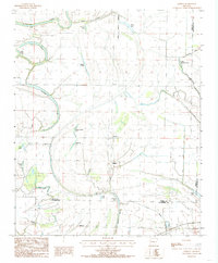 1984 Gieseck1985 Print · USGSEastern Arkansas at the edge of the St. Francis Sunken Lands shows a landscape of engineered drainage and remnant oxbows in the mid-1980s. Genealogists and local historians can trace the footprint of Parkin, Gieseck, and Gladden, alongside landmarks like Patterson Lake and Little Blackfish Lake.2 unique versions available
 - 1984 Map of Parkin, 1985 Print
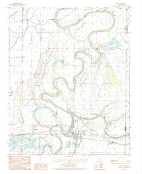 1984 Parkin1985 Print · USGSThe St. Francis River basin in the mid-1980s reveals a landscape of deep river bends and delta wetlands along the Cross County line. Genealogists can locate family sites near Parkin, Coldwater, or Smithdale, and trace the shifting banks of Pemiscot Lake and Barnes Lake.2 unique versions available
 - 1986 Map of Memphis West
 1986 Memphis West1986 Print · USGSThe Mississippi River delta and the rise of Crowleys Ridge define this mid-1980s look at the Mid-South. Researchers can trace the development of West Memphis and Marion or locate landmarks like Crittenden Mem Cem and Village Creek State Park.2 unique versions available
End of results
Showing maps 1-3 of 3
Top cities near Parkin
- Forrest City historical maps
- Wynne historical maps
- Earle historical maps
- Tyronza historical maps
- Cherry Valley historical maps
- Crawfordsville historical maps
See more
Frequently asked questions
- What are the different types of historical maps available for Parkin?
- What is the oldest map of Parkin?
- Where can I purchase historical maps of Parkin for my home or office?
- Where can I download high-res historical maps of Parkin?
- Are there historical topographic maps available for Parkin?
- Is there historical aerial imagery available for Parkin?
- Where are historical maps of Parkin sourced from?