1980s Maps of Johnson County, Arkansas
Explore 9 historic maps of Johnson County from the 1980s. These maps offer a rare glimpse into what life looked like during the 1980s — showing old roads, neighborhoods, homes, and landmarks that have changed or disappeared over time.
Whether you're researching your family's past, planning a metal detecting trip, or studying how Johnson County's landscape evolved across the 1980s, these high-resolution maps are a powerful tool for exploring the history of this region.
- Focus on a specific era: All maps on this page are from the 1980s, giving you a focused view of this time period.
- See what’s changed: Compare century-old streets, trails, and buildings to today's modern landscape using overlays and satellite layers.
- Research with precision: Use these maps for genealogy, historical research, land use analysis, or educational projects.
- View, download, or print: Maps are fully viewable online in high resolution, and can be downloaded or printed for your own records.
Start exploring Johnson County's history through authentic maps from the 1980s. This is your window into the past.
Johnson County, AR maps
(9)- 1980 Map of Hagarville
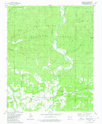 1980 Hagarville1980 Print · USGSHagarville and its surrounding mountain hollows are shown in detail during the late 1970s. Genealogists can trace family landmarks and burial sites including Adkins Cem, Russell Cem, and Minnow Creek Cem, alongside old rural churches like Lees Chapel.
 - 1980 Map of Ozone
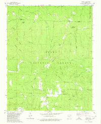 1980 Ozone1980 Print · USGSUpper Johnson County was a landscape of remote ridges and scattered mountain settlements at the dawn of the 1980s. Genealogists and local historians can trace the foundations of Gillian Settlement or locate rural landmarks like Miracle Temple Ch and Salus.
 - 1980 Map of Rosetta
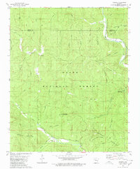 1980 Rosetta1980 Print · USGSThe Ozark highlands near the Johnson and Newton County border are documented here during the late twentieth century. Genealogists and hikers can trace remote landmarks like Rosetta Cem, the peaks of Pilot Rock Mountain, and the waters of Big Piney Creek.
 - 1980 Map of Treat
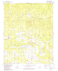
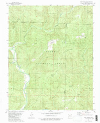
 1980 Treat1980 Print · USGSThe Ozark National Forest's deep valleys and high ridges are documented here in the late seventies. Researchers can trace rural life through the Treat settlement, several family cemeteries like Shannon Cem, and local landmarks such as Bullfrog Valley.2 unique versions available
 - 1980 Map of Ludwig
 1980 Ludwig1980 Print · USGSJohnson County is shown during a period of industrial growth and forest preservation in the late 1970s. Genealogists and historians can trace family roots at Stillwell Cem and Mt Zion Ch or locate the extensive Strip Mine works near Ludwig.
 - 1980 Map of Fort Douglas
 1980 Fort Douglas1980 Print · USGSThe Ozark highlands near the border of Johnson and Newton counties were characterized by isolated settlements and rugged peaks in the 1970s. Researchers can locate family sites such as Fort Douglas, trace the Hurricane Trail, and find remote burial grounds like Wheeler Cem and Self Cem.2 unique versions available
 - 1983 Map of Fly Gap Mountain
 1983 Fly Gap Mountain1983 Print · USGSThe high Ozarks in the early eighties were a landscape of deep river valleys and isolated mountain gaps. Researchers can locate remote settlements like Venus and Cass, or trace family sites at Oark Cem, White Rock Cem, and the Pelsor Post Office.
 - 1984 Map of Russellville
 1984 Russellville1984 Print · USGSThe Arkansas River valley in the mid-eighties shows a landscape defined by the rise of Lake Dardanelle and the enduring presence of the Ozark National Forest. Researchers can find historical institutions like Arkansas Tech Univ and Sacred Heart Church or trace the routes of the Missouri Pacific RR.2 unique versions available
 - 1984 Map of Russellville
 1984 Russellville1984 Print · USGSThe Arkansas River valley was undergoing significant change in the 1950s as transportation and water management reshaped the region from Russellville to Conway. Researchers can trace the era's rail networks like the Missouri Pacific RR and explore landmarks like Magazine Mountain and Petit Jean State Park.
End of results
Showing maps 1-9 of 9
Top cities of Johnson County
- Clarksville historical maps
- Lamar historical maps
- Coal Hill historical maps
- Knoxville historical maps
- Hartman historical maps
Frequently asked questions
- What are the different types of historical maps available for Johnson County?
- What is the oldest map of Johnson County?
- Where can I purchase historical maps of Johnson County for my home or office?
- Where can I download high-res historical maps of Johnson County?
- Are there historical topographic maps available for Johnson County?
- Is there historical aerial imagery available for Johnson County?
- Where are historical maps of Johnson County sourced from?