1800s (19th Century) Maps of Johnson County, Arkansas
Explore 8 historic maps of Johnson County from the 1800s (19th Century). These maps offer a rare glimpse into what life looked like during the 1800s — showing old roads, neighborhoods, homes, and landmarks that have changed or disappeared over time.
Whether you're researching your family's past, planning a metal detecting trip, or studying how Johnson County's landscape evolved across the 1800s, these high-resolution maps are a powerful tool for exploring the history of this region.
- Focus on a specific era: All maps on this page are from the 1800s, giving you a focused view of this time period.
- See what’s changed: Compare century-old streets, trails, and buildings to today's modern landscape using overlays and satellite layers.
- Research with precision: Use these maps for genealogy, historical research, land use analysis, or educational projects.
- View, download, or print: Maps are fully viewable online in high resolution, and can be downloaded or printed for your own records.
Start exploring Johnson County's history through authentic maps from the 1800s. This is your window into the past.
Johnson County, AR maps
(8)- 1887 Map of Magazine Mountain #1
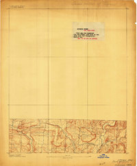
 1887 Magazine Mountain #11887 Print · USGSThe Arkansas River valley in the late 1880s is captured here just as the railroad began reshaping the local economy. Genealogists and researchers can trace early homesteads and rail stops through Paris, Coal Hill, and the river landings at Pattersons Bluff.
 - 1887 Map of Magazine Mountain
 1887 Magazine Mountain1887 Print · USGSNorthwest Arkansas in the 1880s is defined here by the river-and-rail economy along the Arkansas River valley. Genealogists and historians can trace long-forgotten post offices like Burnett Springs and early rail stops such as Coal Hill.
 - 1888 Map of Dardanelle #2
 1888 Dardanelle #21888 Print · USGSJohnson County’s river-and-rail economy is captured here in the late 1880s as the Little Rock & Fort Smith R. R. spurred growth along the Arkansas River. Genealogists and researchers can trace early homesteads near Knoxville, find the river Ferry, and locate settlements like Lutherville and Blaine.
 - 1888 Map of Dardanelle #1
 1888 Dardanelle #11888 Print · USGSPope County at the end of the 1880s was a landscape of rising ridges and vital new rail connections. Family historians can trace early homesteads near Dover and Scottsville, or follow the old tracks of the Little Rock and Fort Smith Railway.
 - 1889 Map of Treat
 1889 Treat1889 Print · USGSInland Pope County is shown in this rare nineteenth-century advance sheet during the early geological survey of the state. Researchers can trace the original topography around the Laurel settlement and family-named landmarks like Evans Hill and Levi Br.
 - 1889 Map of Ozone
 1889 Ozone1889 Print · USGSJohnson County in the late nineteenth century is showcased in this rare advance sheet, featuring the early development of the Ozarks. Genealogists and historians can trace the creek-side settlement of Hagarsville and landmarks like Lick Hill and Grannys Creek.
 - 1890 Map of Magazine Mountain
 1890 Magazine Mountain1890 Print · USGSThe Arkansas River Valley is captured here in the late nineteenth century as rail transport begins to eclipse river travel. Genealogists can trace early homesteads and community hubs like Paris, Booneville, and the remote Burnett Springs.6 unique versions available
 - 1890 Map of Dardanelle
 1890 Dardanelle1890 Print · USGSThe Arkansas River valley was a primary corridor of settlement in the 1890s, anchored by the river towns of Dardanelle and Russellville. Genealogists can locate early homesteads near Mt. Nebo, Lutherville, or the old post office at Chickalah.7 unique versions available
End of results
Showing maps 1-8 of 8
Top cities of Johnson County
- Clarksville historical maps
- Lamar historical maps
- Coal Hill historical maps
- Knoxville historical maps
- Hartman historical maps
Frequently asked questions
- What are the different types of historical maps available for Johnson County?
- What is the oldest map of Johnson County?
- Where can I purchase historical maps of Johnson County for my home or office?
- Where can I download high-res historical maps of Johnson County?
- Are there historical topographic maps available for Johnson County?
- Is there historical aerial imagery available for Johnson County?
- Where are historical maps of Johnson County sourced from?