1970s Maps of Johnson County, Arkansas
Explore 5 historic maps of Johnson County from the 1970s. These maps offer a rare glimpse into what life looked like during the 1970s — showing old roads, neighborhoods, homes, and landmarks that have changed or disappeared over time.
Whether you're researching your family's past, planning a metal detecting trip, or studying how Johnson County's landscape evolved across the 1970s, these high-resolution maps are a powerful tool for exploring the history of this region.
- Focus on a specific era: All maps on this page are from the 1970s, giving you a focused view of this time period.
- See what’s changed: Compare century-old streets, trails, and buildings to today's modern landscape using overlays and satellite layers.
- Research with precision: Use these maps for genealogy, historical research, land use analysis, or educational projects.
- View, download, or print: Maps are fully viewable online in high resolution, and can be downloaded or printed for your own records.
Start exploring Johnson County's history through authentic maps from the 1970s. This is your window into the past.
Johnson County, AR maps
(5)- 1973 Map of Boston, 1976 Print
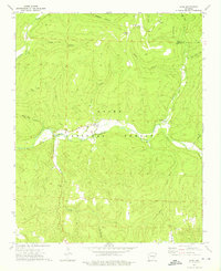
 1973 Boston1976 Print · USGSThe high ridges and deep hollows of the Ozarks are meticulously detailed in the early 1970s, showing the rugged intersection of Madison and Newton counties. Genealogists and historians can locate family sites at Evans Cemetery, rural congregations like Boston Ch, and the isolated settlement of Red Star.2 unique versions available
 - 1973 Map of Pettigrew, 1976 Print
 1973 Pettigrew1976 Print · USGSMadison and Franklin Counties appear here in the early 1970s, showing the remote settlement patterns of the Ozark highlands. Genealogists can locate numerous family burial grounds including Adkins Cem, Kilgore Cem, and Liberty Cem near the banks of the White River.2 unique versions available
 - 1973 Map of Yale, 1976 Print
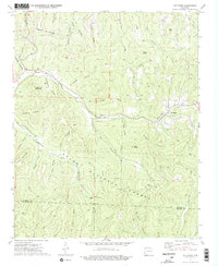
 1973 Yale1976 Print · USGSJohnson and Franklin counties in the 1970s reveal a landscape of deep valleys and highland forests along the Mulberry River. Genealogists and local historians can locate rural landmarks like Peanut, Pittston Junction, and the Good Hope Cem during this era.2 unique versions available
 - 1973 Map of Oark, 1976 Print
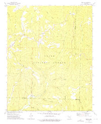
 1973 Oark1976 Print · USGSThe Mulberry River valley in the early 1970s remained a landscape of isolated forest settlements and winding creek beds. Genealogists and local historians can locate family landmarks like Patterson Springs Ch, Miller Cem, and the old community at Oark.2 unique versions available
 - 1977 Map of Russellville
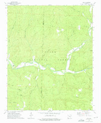
 1977 Russellville1977 Print · USGSThe Arkansas River Valley and surrounding Ozark Mountains are documented here during a period of significant postwar growth and infrastructure development. Genealogists and researchers can locate family landmarks such as Mount Carmel Cem, St Josephs Church, and several remote Coal Mine sites along the Missouri Pacific RR line.
End of results
Showing maps 1-5 of 5
Top cities of Johnson County
- Clarksville historical maps
- Lamar historical maps
- Coal Hill historical maps
- Knoxville historical maps
- Hartman historical maps
Frequently asked questions
- What are the different types of historical maps available for Johnson County?
- What is the oldest map of Johnson County?
- Where can I purchase historical maps of Johnson County for my home or office?
- Where can I download high-res historical maps of Johnson County?
- Are there historical topographic maps available for Johnson County?
- Is there historical aerial imagery available for Johnson County?
- Where are historical maps of Johnson County sourced from?