1930s Maps of Prairie County, Arkansas
Explore 7 historic maps of Prairie County from the 1930s. These maps offer a rare glimpse into what life looked like during the 1930s — showing old roads, neighborhoods, homes, and landmarks that have changed or disappeared over time.
Whether you're researching your family's past, planning a metal detecting trip, or studying how Prairie County's landscape evolved across the 1930s, these high-resolution maps are a powerful tool for exploring the history of this region.
- Focus on a specific era: All maps on this page are from the 1930s, giving you a focused view of this time period.
- See what’s changed: Compare century-old streets, trails, and buildings to today's modern landscape using overlays and satellite layers.
- Research with precision: Use these maps for genealogy, historical research, land use analysis, or educational projects.
- View, download, or print: Maps are fully viewable online in high resolution, and can be downloaded or printed for your own records.
Start exploring Prairie County's history through authentic maps from the 1930s. This is your window into the past.
Prairie County, AR maps
(7)- 1932 Map of Kensett
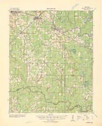 1932 Kensett1932 Print · USGSWhite County in the early thirties is a bustling corridor of rail activity and river commerce. Genealogists and local historians can trace family-named sites across the bottomlands, including Dogwood Ch & Cem, Holloway Sch, and the junction at Kensett.
 - 1935 Map of Kensett
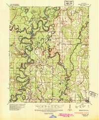
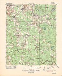 1935 Kensett1935 Print · USGSWhite County in the mid-1930s was defined by the winding Little Red River and a busy network of Missouri Pacific rail lines. Local historians can locate vanished community landmarks like Holloway Sch, Egbert Cem, and the village of Griffithville.2 unique versions available
 - 1935 Map of Hazen, 1936 Print
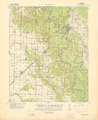
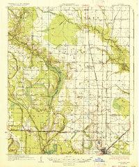
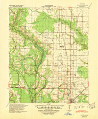
 1935 Hazen1936 Print · USGSPrairie and Lonoke Counties come into focus during the mid-thirties, showing the rail-and-road corridor that linked central Arkansas. Genealogists can trace family roots through numerous rural landmarks like Whippoorwill Cem, Hickory Plains Sch, and Morris Chapel.
 - 1935 Map of Clarendon, 1943 Print
 1935 Clarendon1943 Print · USGSThe river and rail networks of Monroe and Arkansas counties are frozen in time during the mid-1930s. Genealogists and historians can trace family locations through numerous rural landmarks like Mt Zion Ch & Cem, the Ramsey Mill Site, and Harris Ferry.
 - 1935 Map of Gregory, 1946 Print
 1935 Gregory1946 Print · USGSThe Arkansas Delta comes to life in the mid-1930s, showing a river-rich landscape of timber and rail commerce. Genealogists can trace family footprints through rural landmarks like Revel Cem, McClelland, and the riverfront at Georgetown.
 - 1937 Map of Stuttgart
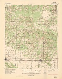
 1937 Stuttgart1937 Print · USGSThe Grand Prairie region of Arkansas is captured here in the mid-1930s, showing the early infrastructure of the rice-growing heartland. Genealogists can trace family roots through numerous country schools and landmarks like Rice Junction, Slovac, and the Gum Pond Cem.3 unique versions available
 - 1939 Map of Stuttgart, 1947 Print
 1939 Stuttgart1947 Print · USGSThe Grand Prairie region of Arkansas is captured here in the late 1930s, showing the agricultural heartland around the rail hub of Stuttgart. Genealogists and historians can trace defunct rural school districts like Fairmount Sch and Hamilton Sch or the early rail alignments of the St Louis Southwestern Ry.
End of results
Showing maps 1-7 of 7
Top cities of Prairie County
- Des Arc historical maps
- Hazen historical maps
- De Valls Bluff historical maps
- Fredonia (Biscoe) historical maps
- Ulm historical maps
Frequently asked questions
- What are the different types of historical maps available for Prairie County?
- What is the oldest map of Prairie County?
- Where can I purchase historical maps of Prairie County for my home or office?
- Where can I download high-res historical maps of Prairie County?
- Are there historical topographic maps available for Prairie County?
- Is there historical aerial imagery available for Prairie County?
- Where are historical maps of Prairie County sourced from?