1960s Maps of Prairie County, Arkansas
Explore 26 historic maps of Prairie County from the 1960s. These maps offer a rare glimpse into what life looked like during the 1960s — showing old roads, neighborhoods, homes, and landmarks that have changed or disappeared over time.
Whether you're researching your family's past, planning a metal detecting trip, or studying how Prairie County's landscape evolved across the 1960s, these high-resolution maps are a powerful tool for exploring the history of this region.
- Focus on a specific era: All maps on this page are from the 1960s, giving you a focused view of this time period.
- See what’s changed: Compare century-old streets, trails, and buildings to today's modern landscape using overlays and satellite layers.
- Research with precision: Use these maps for genealogy, historical research, land use analysis, or educational projects.
- View, download, or print: Maps are fully viewable online in high resolution, and can be downloaded or printed for your own records.
Start exploring Prairie County's history through authentic maps from the 1960s. This is your window into the past.
Prairie County, AR maps
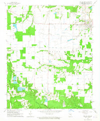
(26)- 1960 Map of Helena
 1960 Helena1960 Print · USGSThe Arkansas and Mississippi Delta regions meet along the great river bends during a period of significant agricultural and rail expansion. Genealogists and historians can trace the paths of the Missouri Pacific railroad through Clarendon or locate landings along the Mississippi River and White River.
 - 1963 Map of Mc Rae, 1964 Print
 1963 Mc Rae1964 Print · USGSThe rail-and-creek landscape of White County comes into focus in the early sixties as the Missouri Pacific connects McRae and Beebe. Local researchers can trace family roots at Bass Cem or Green Cem and locate community landmarks like Harrison Chapel.3 unique versions available
 - 1964 Map of Walker, 1965 Print
 1964 Walker1965 Print · USGSThe bottomlands of White and Prairie counties are captured here in the mid-1960s, showing a landscape defined by the winding Des Arc Bayou. Genealogists can locate family landmarks such as Walker Cem and Vinity Corner, or trace the path of the Old Railroad Grade near Griffithville.2 unique versions available
 - 1964 Map of Hazen, 1965 Print
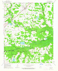
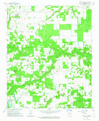
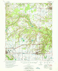
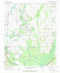
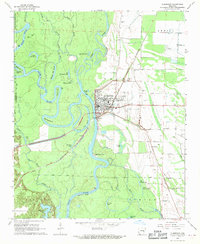
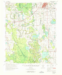
 1964 Hazen1965 Print · USGSHazen and the surrounding Prairie County lowlands are captured here in the mid-1960s as a vital rail and agricultural corridor. Researchers can trace the Chicago Rock Island and Pacific line, locate the Old Bethel Cem, or explore the wooded Wattensaw State Game Area.3 unique versions available
 - 1964 Map of Jasmine, 1965 Print
 1964 Jasmine1965 Print · USGSPrairie and White counties in the mid-1960s reveal a landscape of river brakes and small rural settlements. Researchers can trace family roots through the Belcher Cem, Griffin Cem, and churches like Judson Memorial Ch or Friendship Ch.
 - 1964 Map of Des Arc West, 1965 Print
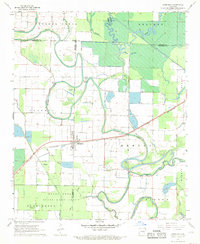
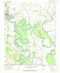
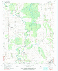
 1964 Des Arc West1965 Print · USGSThe riverfront town of Des Arc and the surrounding bayous are captured here in the mid-1960s. Researchers can locate several burial sites like Oak Grove Cem or trace the remnant of the Old Railroad Grade as it cuts through the bottomlands.2 unique versions available
 - 1964 Map of Hickory Plains, 1965 Print
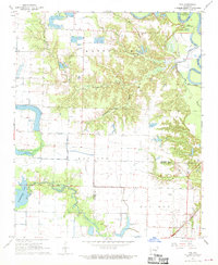
 1964 Hickory Plains1965 Print · USGSHickory Plains and the surrounding Arkansas countryside are documented here in the mid-1960s, showing a landscape of family farms and rural junctions. Genealogists can trace family roots through sites like Hickory Plains Cemetery, Walters Chapel, and McBee Cemetery.
 - 1964 Map of Carlisle, 1965 Print
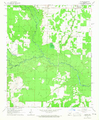
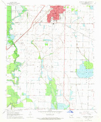
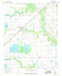
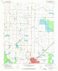
 1964 Carlisle1965 Print · USGSLonoke and Prairie Counties appear here during a period of infrastructure expansion in the mid-1960s. Researchers can trace the Chicago Rock Island and Pacific railroad or locate local landmarks like Mt Zion Cemetery and Screeton.
 - 1967 Map of Kensett
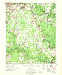 1967 Kensett1967 Print · USGSWhite County, Arkansas, comes to life in this mid-century survey as the regional rail network and the Little Red River shape the local economy. Researchers can locate family landmarks like Ellis Chapel, Liberty Cem, and the old Gravel Pits south of Searcy.
 - 1967 Map of Hazen
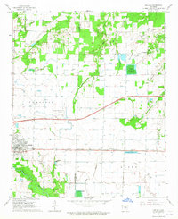
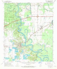
 1967 Hazen1967 Print · USGSPrairie and Lonoke Counties come into focus in the mid-1960s as industrial transport and local agriculture intersect. Genealogists and historians can trace family sites at Tucker Cem, New Bethel Ch, and the rail stops along the Chicago Rock Island and Pacific.
 - 1967 Map of Humphrey, 1969 Print
 1967 Humphrey1969 Print · USGSSurrounding the tri-county junction of Lonoke, Jefferson, and Arkansas counties in the 1960s, this area showcases the intersection of rail and delta wetlands. Genealogists can trace family footprints near Humphrey and rural landmarks like Bayou Meto Ch or Argo Chapel.3 unique versions available
 - 1968 Map of Stuttgart South, 1969 Print
 1968 Stuttgart South1969 Print · USGSThe Grand Prairie region around Stuttgart comes into focus in the late sixties, showing an agricultural hub defined by its rail connections and irrigation. Genealogy researchers can trace family landmarks like Lone Tree Cemetery, St Johns Sch, and the community at Goldman.2 unique versions available
 - 1968 Map of De Valls Bluff SE, 1969 Print
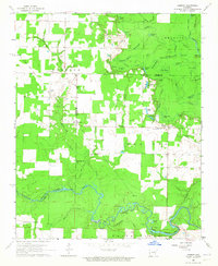
 1968 De Valls Bluff SE1969 Print · USGSMonroe and Prairie counties in the late sixties show a landscape defined by the winding Cache River and its dense network of bayous. Genealogists and historians can trace the rural communities of Eden and Dagmar or locate the Philadelphia Cem and Choctaw Cem.2 unique versions available
 - 1968 Map of De Valls Bluff NE, 1969 Print
 1968 De Valls Bluff NE1969 Print · USGSCotton Plant and the surrounding Delta bottomlands are captured here in the late sixties at the convergence of three counties. Genealogists and local historians can trace rural congregations at Mt Pleasant Ch and Ash Grove Ch or explore the oxbows of the Cache River.3 unique versions available
 - 1968 Map of Des Arc East, 1969 Print
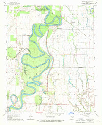
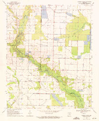
 1968 Des Arc East1969 Print · USGSThe White River delta in the late 1960s reveals a world of complex oxbow lakes and riverfront settlements. Genealogists and researchers can trace the rail corridor of the Chicago Rock Island and Pacific through Letchworth and locate the historic St Luke Cem.
 - 1968 Map of Ulm, 1970 Print
 1968 Ulm1970 Print · USGSThe Grand Prairie region of Arkansas is captured here in the late 1960s, showing a landscape defined by rice farming and rail transit. Researchers can trace the layout of Ulm and find local landmarks like St Paul Ch, Zion Cem, and the St Louis Southwestern railroad.
 - 1968 Map of Gregory SW, 1970 Print
 1968 Gregory SW1970 Print · USGSThe White River lowlands in the late sixties reveal a landscape of deep oxbows and river-fed sloughs. Genealogists and historians can trace the small settlements of Georgetown and McClelland, find the secluded Kings Cem, or follow the Old Railroad Grade through the bottoms.3 unique versions available
 - 1968 Map of Clarendon, 1970 Print
 1968 Clarendon1970 Print · USGSThe riverfront town of Clarendon and the surrounding Arkansas Delta are captured here in the late sixties. Researchers can trace the St Louis Southwestern rail line or locate rural family landmarks like Bateman Cem and Philadelphia Ch.2 unique versions available
 - 1968 Map of De Valls Bluff, 1970 Print
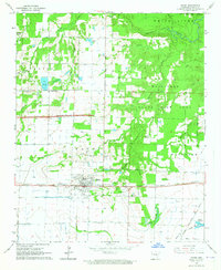
 1968 De Valls Bluff1970 Print · USGSPrairie County in the late sixties reveals a landscape of river-bottom commerce and rail connectivity along the White River. Trace the old rail lines and pioneer burials at Oaklawn Cem or family-named landmarks like Pfennighausen Ridge.3 unique versions available
 - 1968 Map of Cotton Plant, 1970 Print
 1968 Cotton Plant1970 Print · USGSWoodruff County in the late sixties reveals a landscape of river-bottom settlements and winding waterways. Genealogists and historians can trace family locations near Cotton Plant, old landmarks like James Ferry, and rural sites such as Beard Cem.3 unique versions available
 - 1968 Map of Roe, 1970 Print
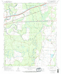
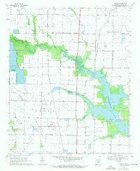
 1968 Roe1970 Print · USGSThe town of Roe stands at the edge of the White River bottoms in the late sixties. Researchers can trace the St Louis Southwestern rail line or locate rural landmarks like Peckerwood Lake, Mt Carmel Ch, and Crosley Slough.
 - 1969 Map of Humphrey
 1969 Humphrey1969 Print · USGSSoutheast Arkansas in the late sixties reveals a landscape of rice farming and rail commerce centered on Stuttgart. Trace the routes of the Southwestern Railway or locate rural landmarks like Lodge Corner, Argo Chapel, and Sunshine Cem.
 - 1969 Map of Slovak, 1971 Print
 1969 Slovak1971 Print · USGSThe Grand Prairie region of Prairie County comes to life in the late sixties as a center of Arkansas rice farming and European immigrant heritage. Trace family roots at the Russian Orthodox Cem and Czech National Cem, or follow the Chicago Rock Island and Pacific rail line through Slovak and Tollville.
 - 1969 Map of Stuttgart North, 1971 Print
 1969 Stuttgart North1971 Print · USGSStuttgart and the Grand Prairie region are seen here at the close of the sixties, shaped by a complex network of reservoirs and irrigation flumes. Genealogists can locate several rural burial sites like Tate Cem and Talman Cem, or trace the tracks of the St Louis Southwestern railroad.
 - 1969 Map of Parkers Corner, 1971 Print
 1969 Parkers Corner1971 Print · USGSIn the heart of the Grand Prairie during the late sixties, this area shows a landscape of intensive water management and rural settlement. Researchers can trace family history at Zion Cem or Ray Cem, and locate the crossroads at Parkers Corner near the Base Line.2 unique versions available
Showing maps 1-25 of 26
Top cities of Prairie County
- Des Arc historical maps
- Hazen historical maps
- De Valls Bluff historical maps
- Fredonia (Biscoe) historical maps
- Ulm historical maps
Frequently asked questions
- What are the different types of historical maps available for Prairie County?
- What is the oldest map of Prairie County?
- Where can I purchase historical maps of Prairie County for my home or office?
- Where can I download high-res historical maps of Prairie County?
- Are there historical topographic maps available for Prairie County?
- Is there historical aerial imagery available for Prairie County?
- Where are historical maps of Prairie County sourced from?