Old Maps of Prairie County, Arkansas for Genealogy
Trace your family roots with 182 historic maps of Prairie County. These high-res maps reveal old neighborhoods, homesites, landmarks, and streets — helping you uncover where your ancestors lived and how the area evolved over time.
- Explore historic neighborhoods: Identify where your relatives may have lived in the 1800s or 1900s.
- Compare maps over time: Trace the changes in streets, buildings, and landmarks for multi-generational research.
- Perfect for genealogy & ancestry research: Used by family historians and researchers to map out lineage and migration.
These maps are an incredible resource for exploring your personal connection to Prairie County's past.
Prairie County, AR maps
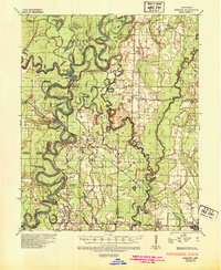
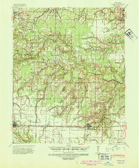
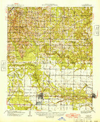
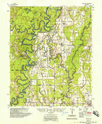
(182)- 1932 Map of Kensett
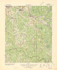 1932 Kensett1932 Print · USGSWhite County in the early thirties is a bustling corridor of rail activity and river commerce. Genealogists and local historians can trace family-named sites across the bottomlands, including Dogwood Ch & Cem, Holloway Sch, and the junction at Kensett.
 - 1935 Map of Kensett
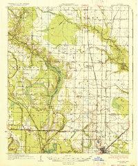
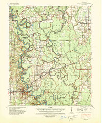
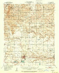
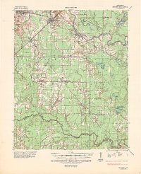 1935 Kensett1935 Print · USGSWhite County in the mid-1930s was defined by the winding Little Red River and a busy network of Missouri Pacific rail lines. Local historians can locate vanished community landmarks like Holloway Sch, Egbert Cem, and the village of Griffithville.2 unique versions available
 - 1935 Map of Hazen, 1936 Print
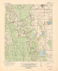
 1935 Hazen1936 Print · USGSPrairie and Lonoke Counties come into focus during the mid-thirties, showing the rail-and-road corridor that linked central Arkansas. Genealogists can trace family roots through numerous rural landmarks like Whippoorwill Cem, Hickory Plains Sch, and Morris Chapel.
 - 1935 Map of Clarendon, 1943 Print
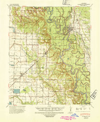
 1935 Clarendon1943 Print · USGSThe river and rail networks of Monroe and Arkansas counties are frozen in time during the mid-1930s. Genealogists and historians can trace family locations through numerous rural landmarks like Mt Zion Ch & Cem, the Ramsey Mill Site, and Harris Ferry.
 - 1935 Map of Gregory, 1946 Print
 1935 Gregory1946 Print · USGSThe Arkansas Delta comes to life in the mid-1930s, showing a river-rich landscape of timber and rail commerce. Genealogists can trace family footprints through rural landmarks like Revel Cem, McClelland, and the riverfront at Georgetown.
 - 1937 Map of Stuttgart
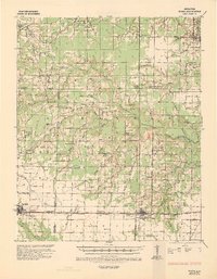
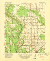
 1937 Stuttgart1937 Print · USGSThe Grand Prairie region of Arkansas is captured here in the mid-1930s, showing the early infrastructure of the rice-growing heartland. Genealogists can trace family roots through numerous country schools and landmarks like Rice Junction, Slovac, and the Gum Pond Cem.3 unique versions available
 - 1939 Map of Stuttgart, 1947 Print
 1939 Stuttgart1947 Print · USGSThe Grand Prairie region of Arkansas is captured here in the late 1930s, showing the agricultural heartland around the rail hub of Stuttgart. Genealogists and historians can trace defunct rural school districts like Fairmount Sch and Hamilton Sch or the early rail alignments of the St Louis Southwestern Ry.
 - 1940 Map of Lonoke
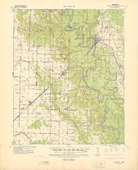
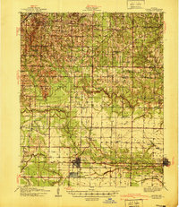 1940 Lonoke1940 Print · USGSThe Lonoke County interior during the late Depression era shows a landscape of rail-dependent towns and prairie farmsteads. Researchers can trace the early road network and family history through sites like Butlerville, the Confederate Cemetery, and Carlisle.
 - 1941 Map of Hazen, 1942 Print
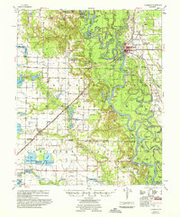
 1941 Hazen1942 Print · USGSThe Grand Prairie region of Arkansas is captured here during the early 1940s, showing a landscape defined by the arrival of the Chicago Rock Island and Pacific railroad. Genealogists can locate family sites among numerous rural hubs like Philadelphia Ch, Hazen, and Barrettsville Sch.2 unique versions available
 - 1941 Map of De Valls Bluff, 1943 Print
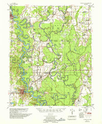
 1941 De Valls Bluff1943 Print · USGSThe White River basin in the early 1940s reveals a landscape of complex oxbows and timbered bottomlands. Genealogists and historians can trace family roots through numerous local landmarks like St Johns Cem, Beulah, and the Richland Sch.2 unique versions available
 - 1941 Map of Goldman, 1944 Print
 1941 Goldman1944 Print · USGSThe Arkansas delta landscape comes alive in this early 1940s record of a river-bound territory. Researchers can trace family history through dozens of rural landmarks, including Flynn Ch & Cem, Goldman School, and the scattered settlements of Ricusskey and Humphrey.2 unique versions available
 - 1941 Map of Clarendon, 1946 Print
 1941 Clarendon1946 Print · USGSThe river-driven economy of the Arkansas delta is on full display here in the early 1940s, centered on the confluence of the White and Cache rivers. Genealogists and historians can trace long-standing landmarks like Preston Ferry, the Ramsey Mill Site, and Lookout Store.2 unique versions available
 - 1948 Map of Helena
 1948 Helena1948 Print · USGSEastern Arkansas and the Mississippi Delta are captured here just after the war, showing a landscape defined by its great rivers and rail lines. Genealogists can trace family locations near Bemis Plantation, Helena, and smaller rail stops like Wheatley and Moro.
 - 1949 Map of Lonoke
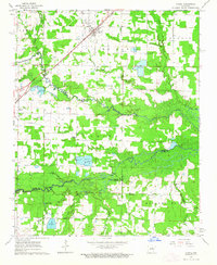
 1949 Lonoke1949 Print · USGSLonoke and Carlisle are captured in the late thirties, when the Chicago Rock Island and Pacific railroad defined the local corridor. Genealogists can trace family footprints at the Camp Nelson Confederate Cem and rural schools like Pittman Sch or Bethlehem Sch.
 - 1950 Map of Helena
 1950 Helena1950 Print · USGSMid-century Phillips County and the surrounding Delta region are shown at a peak of rail and river commerce. Genealogists and historians can trace family locations through numerous rural communities like Old Austin, Cotton Plant, and West Helena, or follow the routes of the Missouri Pacific RR across Grand Prairie.2 unique versions available
 - 1950 Map of Lonoke, 1952 Print
 1950 Lonoke1952 Print · USGSLonoke and Carlisle are centered in this mid-century survey of central Arkansas, highlighting a landscape shaped by rail and river. Genealogists can trace family roots at Camp Nelson Confederate Cem or locate rural landmarks like Jacksons Store and Sylvania.2 unique versions available
 - 1953 Map of Memphis, 1966 Print
 1953 Memphis1966 Print · USGSEastern Arkansas and the Memphis riverfront are shown here during the mid-century period of regional growth and river management. Local historians can trace the paths of the Chicago Rock Island & Pacific RR through Forrest City or locate river landmarks like President's Island.3 unique versions available
 - 1955 Map of Helena, 1967 Print
 1955 Helena1967 Print · USGSThe Arkansas Delta and Mississippi floodplains are captured here in the mid-fifties, during a period of expanding flood control and rail commerce. Researchers can trace the extensive Chicago Rock Island and Pacific RR lines and locate sites like the Arkansas State College Experimental Rice Farm or Friars Point.2 unique versions available
 - 1956 Map of Memphis
 1956 Memphis1956 Print · USGSThe Mississippi Delta and the bluffs of West Tennessee meet in the mid-fifties, showing a landscape defined by massive river systems and rail hubs. Researchers can trace the path of Crowleys Ridge or locate vanished river landings near Centennial Island and Island No 35.
 - 1957 Map of Clarendon
 1957 Clarendon1957 Print · USGSThe river and rail landscapes of the Arkansas Delta come alive in this mid-fifties survey of the Clarendon area. Genealogists and local historians can trace family roots at numerous rural landmarks like Mt Pisgah Ch & Cem, Stahley Sch, and the Ramsey Mill Site.
 - 1957 Map of De Valls Bluff
 1957 De Valls Bluff1957 Print · USGSThe river bottoms of the White and Cache rivers are captured here in the late fifties, showcasing a complex world of oxbow lakes and rail-line settlements. Genealogists and historians can locate rural landmarks such as St. Johns Cem, Beulah, and Ash Grove Ch & Cem.
 - 1957 Map of Gregory
 1957 Gregory1957 Print · USGSThe White River valley comes into sharp focus during the late fifties, showing a landscape of river-bend settlements and rail hubs. Genealogists can trace family names and rural communities through Walnut Grove Sch, Crutcher Cem, and the streets of Cotton Plant.
 - 1959 Map of Helena
 1959 Helena1959 Print · USGSThe Arkansas and Mississippi Delta regions are captured here in the late fifties, showing a landscape defined by the Mississippi River and the Grand Prairie. Genealogists and researchers can trace the rail networks of the Illinois Central RR and locate community landmarks like Helena and the White River National Wildlife Refuge.
 - 1960 Map of Helena
 1960 Helena1960 Print · USGSThe Arkansas and Mississippi Delta regions meet along the great river bends during a period of significant agricultural and rail expansion. Genealogists and historians can trace the paths of the Missouri Pacific railroad through Clarendon or locate landings along the Mississippi River and White River.
 - 1963 Map of Mc Rae, 1964 Print
 1963 Mc Rae1964 Print · USGSThe rail-and-creek landscape of White County comes into focus in the early sixties as the Missouri Pacific connects McRae and Beebe. Local researchers can trace family roots at Bass Cem or Green Cem and locate community landmarks like Harrison Chapel.3 unique versions available
Showing maps 1-25 of 182
Top cities of Prairie County
- Des Arc historical maps
- Hazen historical maps
- De Valls Bluff historical maps
- Fredonia (Biscoe) historical maps
- Ulm historical maps
Frequently asked questions
- What are the different types of historical maps available for Prairie County?
- What is the oldest map of Prairie County?
- Where can I purchase historical maps of Prairie County for my home or office?
- Where can I download high-res historical maps of Prairie County?
- Are there historical topographic maps available for Prairie County?
- Is there historical aerial imagery available for Prairie County?
- Where are historical maps of Prairie County sourced from?