1970s Maps of Prairie County, Arkansas
Explore 4 historic maps of Prairie County from the 1970s. These maps offer a rare glimpse into what life looked like during the 1970s — showing old roads, neighborhoods, homes, and landmarks that have changed or disappeared over time.
Whether you're researching your family's past, planning a metal detecting trip, or studying how Prairie County's landscape evolved across the 1970s, these high-resolution maps are a powerful tool for exploring the history of this region.
- Focus on a specific era: All maps on this page are from the 1970s, giving you a focused view of this time period.
- See what’s changed: Compare century-old streets, trails, and buildings to today's modern landscape using overlays and satellite layers.
- Research with precision: Use these maps for genealogy, historical research, land use analysis, or educational projects.
- View, download, or print: Maps are fully viewable online in high resolution, and can be downloaded or printed for your own records.
Start exploring Prairie County's history through authentic maps from the 1970s. This is your window into the past.
Prairie County, AR maps
(4)- 1971 Map of De Valls Bluff
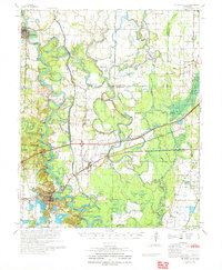 1971 De Valls Bluff1971 Print · USGSPrairie County's river-driven landscape is shown here in the early 1970s, as railroads and river landings still defined the region's character. Researchers can locate family landmarks like St Luke Cem, Philadelphia Cem, and the community of Biscoe along the White River.
 - 1971 Map of Stuttgart
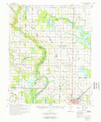 1971 Stuttgart1971 Print · USGSThe Grand Prairie region of Arkansas comes alive in the early 1970s, showing the meeting of three counties and two major railroads. Researchers can trace the heritage of local communities like Slovak and Fairmount or locate family plots at Geridge Cemetery and Tate Cemetery.
 - 1972 Map of Gregory
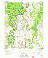 1972 Gregory1972 Print · USGSIn the Arkansas Delta during the early 1970s, the river-carved landscape of Woodruff and White counties supported a mix of timber and agriculture. Trace the footprints of rural life at Cotton Plant, Georgetown, and the Indian Mound Cemetery.2 unique versions available
 - 1972 Map of Clarendon
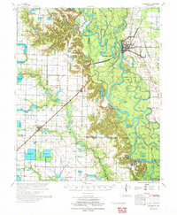 1972 Clarendon1972 Print · USGSThe Arkansas Delta in the early seventies centers on the river and rail hub of Clarendon at the confluence of the White River. Researchers can trace old family landmarks across the bottomlands, from the Bateman Cem and Hunter Chapel to the Preston Ferry crossing.
End of results
Showing maps 1-4 of 4
Top cities of Prairie County
- Des Arc historical maps
- Hazen historical maps
- De Valls Bluff historical maps
- Fredonia (Biscoe) historical maps
- Ulm historical maps
Frequently asked questions
- What are the different types of historical maps available for Prairie County?
- What is the oldest map of Prairie County?
- Where can I purchase historical maps of Prairie County for my home or office?
- Where can I download high-res historical maps of Prairie County?
- Are there historical topographic maps available for Prairie County?
- Is there historical aerial imagery available for Prairie County?
- Where are historical maps of Prairie County sourced from?