1900-1909 Maps of Amador County, California
Explore 5 historic maps of Amador County from 1900-1909. These maps offer a rare glimpse into what life looked like during the 1900s — showing old roads, neighborhoods, homes, and landmarks that have changed or disappeared over time.
Whether you're researching your family's past, planning a metal detecting trip, or studying how Amador County's landscape evolved across the 1900s, these high-resolution maps are a powerful tool for exploring the history of this region.
- Focus on a specific era: All maps on this page are from the 1900s, giving you a focused view of this time period.
- See what’s changed: Compare century-old streets, trails, and buildings to today's modern landscape using overlays and satellite layers.
- Research with precision: Use these maps for genealogy, historical research, land use analysis, or educational projects.
- View, download, or print: Maps are fully viewable online in high resolution, and can be downloaded or printed for your own records.
Start exploring Amador County's history through authentic maps from the 1900s. This is your window into the past.
Amador County, CA maps
(5)- 1901 Map of Big Trees
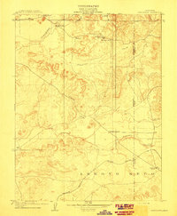
 1901 Big Trees1901 Print · USGSThe High Sierra and Gold Country meet in this turn-of-the-century look at the groves and mining camps of the Mokelumne and Stanislaus watersheds. Trace the early boundaries of the Calaveras Grove, locate the Riverside Mine, or find river crossings like Parrott Ferry.9 unique versions available
 - 1902 Map of Jackson
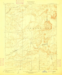
 1902 Jackson1902 Print · USGSAmador and Calaveras counties are captured at the height of the mining era in this late nineteenth-century survey. Genealogists and historians can trace the rail lines of the Stockton and Copperopolis Railroad and find long-established camps like Lancha Plana and Jesus Maria.7 unique versions available
 - 1909 Map of Carbondale
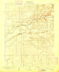
 1909 Carbondale1909 Print · USGSSacramento and Amador counties meet along the river and rail lines in the first decade of the twentieth century. Genealogists can locate established rural centers like Carbondale and Alabama House, alongside local schoolhouses such as Stone House School and Buckeye School.2 unique versions available
 - 1909 Map of Goose Creek
 1909 Goose Creek1909 Print · USGSThe foothills where Sacramento, Amador, and San Joaquin counties meet are captured here in the years before the Great War. Genealogists and historians can locate the Hutson School and trace the path of the Southern Pacific R. R. (Amador Branch) alongside Dry Creek.2 unique versions available
 - 1909 Map of Clements
 1909 Clements1909 Print · USGSClements and the Mokelumne River valley appear here in the early twentieth century, showing a landscape defined by ranching and rail. Researchers can locate vanished landmarks like Dogtown, Justice School, and the Southern Pacific R R line.2 unique versions available
End of results
Showing maps 1-5 of 5
Top cities of Amador County
- Ione historical maps
- Jackson historical maps
- Sutter Creek historical maps
- Plymouth historical maps
- Amador City historical maps
Frequently asked questions
- What are the different types of historical maps available for Amador County?
- What is the oldest map of Amador County?
- Where can I purchase historical maps of Amador County for my home or office?
- Where can I download high-res historical maps of Amador County?
- Are there historical topographic maps available for Amador County?
- Is there historical aerial imagery available for Amador County?
- Where are historical maps of Amador County sourced from?