2000-2009 Maps of Amador County, California
Explore 4 historic maps of Amador County from 2000-2009. These maps offer a rare glimpse into what life looked like during the 2000s — showing old roads, neighborhoods, homes, and landmarks that have changed or disappeared over time.
Whether you're researching your family's past, planning a metal detecting trip, or studying how Amador County's landscape evolved across the 2000s, these high-resolution maps are a powerful tool for exploring the history of this region.
- Focus on a specific era: All maps on this page are from the 2000s, giving you a focused view of this time period.
- See what’s changed: Compare century-old streets, trails, and buildings to today's modern landscape using overlays and satellite layers.
- Research with precision: Use these maps for genealogy, historical research, land use analysis, or educational projects.
- View, download, or print: Maps are fully viewable online in high resolution, and can be downloaded or printed for your own records.
Start exploring Amador County's history through authentic maps from the 2000s. This is your window into the past.
Amador County, CA maps
(4)- 2001 Map of Devils Nose, 2004 Print
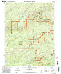 2001 Devils Nose2004 Print · USGSThe Amador and Calaveras county line at the start of the millennium highlights a landscape of high ridges and hydroelectric infrastructure. Researchers can trace the rugged water systems from the Tiger Creek Reservoir to the Mokelumne River, while locating secluded spots like Whitmore Meadow and Boston Flat.
 - 2001 Map of Tamarack, 2004 Print
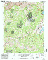 2001 Tamarack2004 Print · USGSHigh Sierra recreation and pioneer history meet in this early 2000s survey of the Stanislaus National Forest. Genealogists and historians can trace the Emigrant Trail and the Bloods Toll Sta Hist Site alongside developments like Sherman Acres.2 unique versions available
 - 2001 Map of Calaveras Dome, 2004 Print
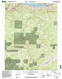 2001 Calaveras Dome2004 Print · USGSThe High Sierra backcountry near the Amador and Calaveras border comes to life in this era of forest management and water engineering. Trace high-altitude landmarks and resource sites from Cuneo Camp and Ganns to the Shovel Grave Quarry.
 - 2001 Map of Garnet Hill, 2004 Print
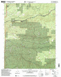 2001 Garnet Hill2004 Print · USGSThe Sierra Nevada foothills come into focus at the turn of the millennium where the Amador and Calaveras county lines meet. Researchers can trace historic mining activity at Moore Mine or follow the winding North Fork Mokelumne River and Licking Fork.
End of results
Showing maps 1-4 of 4
Top cities of Amador County
- Ione historical maps
- Jackson historical maps
- Sutter Creek historical maps
- Plymouth historical maps
- Amador City historical maps
Frequently asked questions
- What are the different types of historical maps available for Amador County?
- What is the oldest map of Amador County?
- Where can I purchase historical maps of Amador County for my home or office?
- Where can I download high-res historical maps of Amador County?
- Are there historical topographic maps available for Amador County?
- Is there historical aerial imagery available for Amador County?
- Where are historical maps of Amador County sourced from?