1960s Maps of Amador County, California
Explore 11 historic maps of Amador County from the 1960s. These maps offer a rare glimpse into what life looked like during the 1960s — showing old roads, neighborhoods, homes, and landmarks that have changed or disappeared over time.
Whether you're researching your family's past, planning a metal detecting trip, or studying how Amador County's landscape evolved across the 1960s, these high-resolution maps are a powerful tool for exploring the history of this region.
- Focus on a specific era: All maps on this page are from the 1960s, giving you a focused view of this time period.
- See what’s changed: Compare century-old streets, trails, and buildings to today's modern landscape using overlays and satellite layers.
- Research with precision: Use these maps for genealogy, historical research, land use analysis, or educational projects.
- View, download, or print: Maps are fully viewable online in high resolution, and can be downloaded or printed for your own records.
Start exploring Amador County's history through authentic maps from the 1960s. This is your window into the past.
Amador County, CA maps
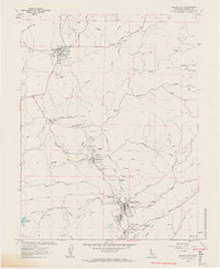
(11)- 1962 Map of Wallace, 1963 Print
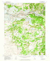 1962 Wallace1963 Print · USGSCalaveras County is captured here just before the waters rose to create the Camanche Reservoir in the early sixties. Genealogists and local historians can trace the original locations of Lancha Plana and Camanche before they were inundated, alongside the tracks of the Southern Pacific.3 unique versions available
 - 1962 Map of Jackson, 1963 Print
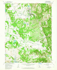
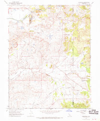
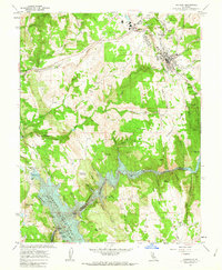 1962 Jackson1963 Print · USGSAmador County mining history is on full display in the early sixties, showing the transition from deep-shaft gold mines to modern water infrastructure. Researchers can trace family sites near Jackson Gate, the path of the Amador Central railroad, and legendary claims like the Kennedy Mine.3 unique versions available
 - 1962 Map of Irish Hill, 1963 Print
 1962 Irish Hill1963 Print · USGSAmador County was a landscape of active resource extraction and rural settlement in the early sixties. Researchers can trace the industrial footprint of Claypit and Mine sites, locate the Willow Springs Sch, or follow the Southern Pacific rail line past Edwin.2 unique versions available
 - 1962 Map of Valley Springs, 1963 Print
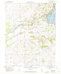
 1962 Valley Springs1963 Print · USGSCalaveras County is captured here in the early sixties during a period of massive water infrastructure expansion. Genealogists and historians can trace the foundations of Valley Springs, the legacy of the Penn Mine, and the rising waters of the New Hogan Reservoir.3 unique versions available
 - 1962 Map of Amador City, 1963 Print
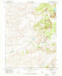
 1962 Amador City1963 Print · USGSThe California Mother Lode is seen here in the early sixties during a period of established mining and community growth. Genealogists and historians can trace the legacy of the gold rush through the Old Eureka, Keystone Mine, and Oak Knoll Cemetery.4 unique versions available
 - 1962 Map of Ione, 1963 Print
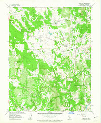
 1962 Ione1963 Print · USGSAmador County is shown in the early sixties during a period of transition, as the Camanche Reservoir began to reshape the southern landscape. Researchers can trace the extensive grounds of the Preston School of Industry and numerous local Claypits near Ione.2 unique versions available
 - 1962 Map of Sutter Creek, 1964 Print
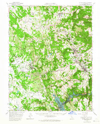 1962 Sutter Creek1964 Print · USGSAmador County's gold-mining heartland is captured here in the early sixties, just as the Mokelumne River was being transformed by the Camanche Reservoir. Genealogists and historians can trace the foundations of the Mother Lode through labels for the Kennedy Mine, Church Bell Hill, and the Amador Co High Sch.2 unique versions available
 - 1962 Map of Valley Springs, 1964 Print
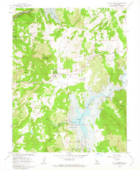
 1962 Valley Springs1964 Print · USGSWestern Calaveras County is seen here just as new water projects were poised to transform the landscape. Researchers can trace historic settlements like Camanche and Lancha Plana or locate old mining sites such as Penn Mine and McCarty Mine.2 unique versions available
 - 1968 Map of Carbondale, 1970 Print
 1968 Carbondale1970 Print · USGSSacramento and Amador counties are captured here in the late sixties, a landscape defined by the legacies of industrial mining and old rail lines. Genealogists and historians can trace family-named routes like Pony Brown Road or locate the Michigan Bar Cem and Carbondale settlement.7 unique versions available
 - 1968 Map of Clements, 1972 Print
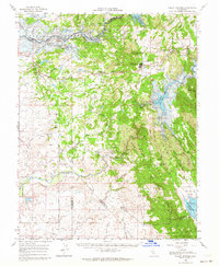
 1968 Clements1972 Print · USGSClements and Dogtown are shown in the late sixties as the Mokelumne River's role in California's water system expands with new infrastructure. Genealogists and historians can locate the Clements Glen View Cemetery, trace the Southern Pacific rail line, and see the Camanche Dam at the edge of the reservoir.3 unique versions available
 - 1968 Map of Goose Creek, 1972 Print
 1968 Goose Creek1972 Print · USGSThe rural Sacramento County foothills come into focus in the late sixties at the intersection of three counties. Genealogists and local historians can trace the Pacific Southern rail line, the settlement at Hadselville, and the extensive Dredge Tailings left by earlier mining operations.4 unique versions available
End of results
Showing maps 1-11 of 11
Top cities of Amador County
- Ione historical maps
- Jackson historical maps
- Sutter Creek historical maps
- Plymouth historical maps
- Amador City historical maps
Frequently asked questions
- What are the different types of historical maps available for Amador County?
- What is the oldest map of Amador County?
- Where can I purchase historical maps of Amador County for my home or office?
- Where can I download high-res historical maps of Amador County?
- Are there historical topographic maps available for Amador County?
- Is there historical aerial imagery available for Amador County?
- Where are historical maps of Amador County sourced from?