1910s Maps of Calaveras County, California
Explore 2 historic maps of Calaveras County from the 1910s. These maps offer a rare glimpse into what life looked like during the 1910s — showing old roads, neighborhoods, homes, and landmarks that have changed or disappeared over time.
Whether you're researching your family's past, planning a metal detecting trip, or studying how Calaveras County's landscape evolved across the 1910s, these high-resolution maps are a powerful tool for exploring the history of this region.
- Focus on a specific era: All maps on this page are from the 1910s, giving you a focused view of this time period.
- See what’s changed: Compare century-old streets, trails, and buildings to today's modern landscape using overlays and satellite layers.
- Research with precision: Use these maps for genealogy, historical research, land use analysis, or educational projects.
- View, download, or print: Maps are fully viewable online in high resolution, and can be downloaded or printed for your own records.
Start exploring Calaveras County's history through authentic maps from the 1910s. This is your window into the past.
Calaveras County, CA maps
(2)- 1916 Map of Bachelor Valley
 1916 Bachelor Valley1916 Print · USGSBachelor Valley and the surrounding ranchos are captured here in the early twentieth century during a period of rural development. Researchers can trace early school sites like Bachelor Valley School, the operations at Quail Hill Mine, and the village of Eugene.
 - 1916 Map of Copperopolis
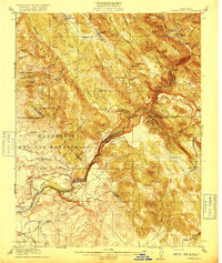 1916 Copperopolis1916 Print · USGSCalaveras and Stanislaus counties at the height of the early copper and ranching era reveal a landscape of deep canyons and mining outposts. Trace the Sierra Ry of California or locate historic crossings like Reynolds Ferry and the Wilbur-Womble Mine.3 unique versions available
End of results
Showing maps 1-2 of 2
Top cities of Calaveras County
Frequently asked questions
- What are the different types of historical maps available for Calaveras County?
- What is the oldest map of Calaveras County?
- Where can I purchase historical maps of Calaveras County for my home or office?
- Where can I download high-res historical maps of Calaveras County?
- Are there historical topographic maps available for Calaveras County?
- Is there historical aerial imagery available for Calaveras County?
- Where are historical maps of Calaveras County sourced from?