1920s Maps of Tranquillity, California
Explore 2 historic maps of Tranquillity from the 1920s. These maps offer a rare glimpse into what life looked like during the 1920s — showing old roads, neighborhoods, homes, and landmarks that have changed or disappeared over time.
Whether you're researching your family's past, planning a metal detecting trip, or studying how Tranquillity's landscape evolved across the 1920s, these high-resolution maps are a powerful tool for exploring the history of this region.
- Focus on a specific era: All maps on this page are from the 1920s, giving you a focused view of this time period.
- See what’s changed: Compare century-old streets, trails, and buildings to today's modern landscape using overlays and satellite layers.
- Research with precision: Use these maps for genealogy, historical research, land use analysis, or educational projects.
- View, download, or print: Maps are fully viewable online in high resolution, and can be downloaded or printed for your own records.
Start exploring Tranquillity's history through authentic maps from the 1920s. This is your window into the past.
Tranquillity, CA maps
(2)- 1924 Map of Jamesan
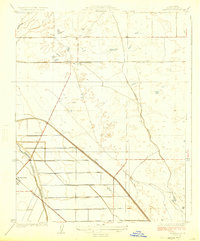 1924 Jamesan1924 Print · USGSFresno County agriculture and infrastructure were rapidly expanding in the mid-1920s. Genealogists and researchers can trace the early rail-and-water network through Jamesan, Tranquillity, and the Southern Pacific rail line.2 unique versions available
 - 1924 Map of Tranquillity
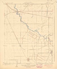 1924 Tranquillity1924 Print · USGSThe Fresno County ranch lands near Tranquillity are captured here in the early twenties, showing a landscape shaped by large holdings and the Southern Pacific. Researchers can locate family landmarks like Herminghaus Ranch and trace the Kings River Slough.3 unique versions available
End of results
Showing maps 1-2 of 2
Top cities near Tranquillity
Frequently asked questions
- What are the different types of historical maps available for Tranquillity?
- What is the oldest map of Tranquillity?
- Where can I purchase historical maps of Tranquillity for my home or office?
- Where can I download high-res historical maps of Tranquillity?
- Are there historical topographic maps available for Tranquillity?
- Is there historical aerial imagery available for Tranquillity?
- Where are historical maps of Tranquillity sourced from?