1940s Maps of Tranquillity, California
Explore 4 historic maps of Tranquillity from the 1940s. These maps offer a rare glimpse into what life looked like during the 1940s — showing old roads, neighborhoods, homes, and landmarks that have changed or disappeared over time.
Whether you're researching your family's past, planning a metal detecting trip, or studying how Tranquillity's landscape evolved across the 1940s, these high-resolution maps are a powerful tool for exploring the history of this region.
- Focus on a specific era: All maps on this page are from the 1940s, giving you a focused view of this time period.
- See what’s changed: Compare century-old streets, trails, and buildings to today's modern landscape using overlays and satellite layers.
- Research with precision: Use these maps for genealogy, historical research, land use analysis, or educational projects.
- View, download, or print: Maps are fully viewable online in high resolution, and can be downloaded or printed for your own records.
Start exploring Tranquillity's history through authentic maps from the 1940s. This is your window into the past.
Tranquillity, CA maps
(4)- 1946 Map of Tranquillity, 1953 Print
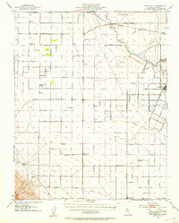 1946 Tranquillity1953 Print · USGSAgricultural life in Fresno County during the mid-1940s revolved around rail transport and water management. Genealogists and historians can trace family operations like Coit Ranch and Englebrecht Ranch or follow the Southern Pacific through Tranquillity.
 - 1947 Map of Tranquillity
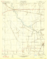 1947 Tranquillity1947 Print · USGSFresno County agriculture and rail networks come into focus in the late 1940s. Researchers can trace the development of irrigation near Tranquillity and follow the Southern Pacific tracks through Mendota and the Herminghaus Ranch.
 - 1947 Map of Jamesan
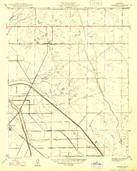 1947 Jamesan1947 Print · USGSFresno County's agricultural heartland is captured in the late 1940s, showcasing a landscape transformed by railroads and irrigation. Genealogists and local historians can trace the early foundations of Jamesan and Tranquillity along the Southern Pacific line.
 - 1948 Map of Santa Cruz
 1948 Santa Cruz1948 Print · USGSThe Central Coast and San Joaquin Valley meet in this mid-century look at the region's agricultural and military geography. Genealogists and historians can trace the paths of El Camino Real, locate family farms near Hollister, or study the footprint of the Fort Ord Military Reservation.2 unique versions available
End of results
Showing maps 1-4 of 4
Top cities near Tranquillity
Frequently asked questions
- What are the different types of historical maps available for Tranquillity?
- What is the oldest map of Tranquillity?
- Where can I purchase historical maps of Tranquillity for my home or office?
- Where can I download high-res historical maps of Tranquillity?
- Are there historical topographic maps available for Tranquillity?
- Is there historical aerial imagery available for Tranquillity?
- Where are historical maps of Tranquillity sourced from?