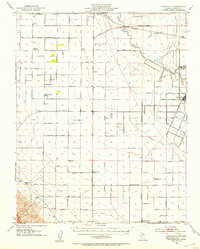
1946 Map of Tranquillity
USGS Topo · Published 1953About this map
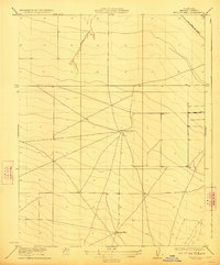
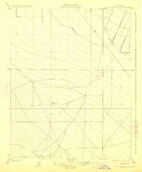
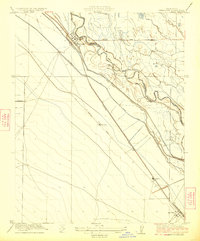
Tranquillity serves as the primary hub of this agricultural landscape in the San Joaquin Valley, where the Southern Pacific railroad and a dense network of irrigation infrastructure dictate the pattern of settlement. Extensive landholdings like Coit Ranch, Murietta Farm, and the Herminghaus Ranch dominate the geography, reflecting the scale of industrial farming in Fresno County during the mid-1940s. The region's water management is clearly delineated by the Fresno Slough, the Beta Main Canal, and the Fresno Slough By-Pass, which channel water across the flat terrain. Evidence of the area's changing hydrology is marked by an Abandoned Canal winding through the eastern sections. Smaller clusters of activity appear at Levis and the Midway Ranch, while the Cantua School provides a localized landmark for rural families near Cantua Creek.
Find a feature on this map
79 named features on this map. Tap any name to fly to it.
Don’t see what you’re looking for? This feature index may not catch every label — zoom into the map to look around manually.
Map Details
Editions of this 1946 Tranquillity Map
This is the sole edition of this map. No revisions or reprints were ever made.
Other maps of this area

1912 · Coalinga
USGS Topo · 1:125,000

1913 · Panoche
USGS Topo · 1:125,000

1915 · Priest Valley
USGS Topo · 1:125,000

1921 · Mendota
USGS Topo · 1:31,680
1922 · Tufts Ranch
USGS Topo · 1:31,680
1922 · Chaney Ranch
USGS Topo · 1:31,680
1923 · Levis
USGS Topo · 1:31,680
1923 · Wisdom Well
USGS Topo · 1:31,680
1923 · Englebrecht Ranch
USGS Topo · 1:31,680
1923 · Firebaugh
USGS Topo · 1:31,680