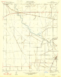
1947 Map of Tranquillity
USGS Topo · Published 1947About this map
Tranquillity and Mendota anchor this post-war landscape in the San Joaquin Valley, where the natural water systems of Fresno Slough were being heavily managed for agriculture. The map captures an era of expanding irrigation and systematic land division, evidenced by the dense grid of avenues including Washington Avenue and James Avenue that structure the valley floor. The Southern Pacific railroad cuts a diagonal line across the terrain, connecting the small siding of Ingle to the larger regional hubs. The presence of the Herminghaus Ranch and the Fresno Slough Bypass highlights the transition from traditional ranching to engineered water control. Large tracts are defined by these surveyed roads and sloughs, showing how the Central Valley's topography was being reshaped into one of the most productive farming districts in California during the late 1940s.
Find a feature on this map
33 named features on this map. Tap any name to fly to it.
Don’t see what you’re looking for? This feature index may not catch every label — zoom into the map to look around manually.
Map Details
Editions of this 1947 Tranquillity Map
This is the sole edition of this map. No revisions or reprints were ever made.
Other maps of this area

1921 · Mendota
USGS Topo · 1:31,680

1922 · Tufts Ranch
USGS Topo · 1:31,680

1923 · Levis
USGS Topo · 1:31,680

1923 · Englebrecht Ranch
USGS Topo · 1:31,680

1923 · Firebaugh
USGS Topo · 1:31,680

1924 · Jamesan
USGS Topo · 1:31,680

1924 · Tranquillity
USGS Topo · 1:31,680

1924 · Gravelly Ford
USGS Topo · 1:31,680

1924 · Mendota
USGS Topo · 1:31,680

1925 · San Joaquin
USGS Topo · 1:31,680