1900s (20th Century) Maps of Glendora, California
Explore 27 historic maps of Glendora from the 1900s (20th Century). These maps offer a rare glimpse into what life looked like during the 1900s — showing old roads, neighborhoods, homes, and landmarks that have changed or disappeared over time.
Whether you're researching your family's past, planning a metal detecting trip, or studying how Glendora's landscape evolved across the 1900s, these high-resolution maps are a powerful tool for exploring the history of this region.
- Focus on a specific era: All maps on this page are from the 1900s, giving you a focused view of this time period.
- See what’s changed: Compare century-old streets, trails, and buildings to today's modern landscape using overlays and satellite layers.
- Research with precision: Use these maps for genealogy, historical research, land use analysis, or educational projects.
- View, download, or print: Maps are fully viewable online in high resolution, and can be downloaded or printed for your own records.
Start exploring Glendora's history through authentic maps from the 1900s. This is your window into the past.
Glendora, CA maps
(27)- 1901 Map of Southern California Sheet No. 1
 1901 Southern California Sheet No. 11901 Print · USGSGreater Los Angeles at the dawn of the twentieth century is a landscape of growing citrus towns and a burgeoning rail network. Genealogists and historians can trace the early gridded streets of Hollywood and Pasadena or locate landmarks like Bear Lake and the Cahuilla Indian Reservation.6 unique versions available
 - 1904 Map of Pomona
 1904 Pomona1904 Print · USGSThe eastern San Gabriel Valley is shown here at the turn of the century as a burgeoning network of citrus towns and vital rail lines. Genealogists can trace early homesteads and vanished stops such as Lordsburg, Alosta, and the Rowland Siding along the Southern Pacific RR.7 unique versions available
 - 1904 Map of Southern California Sheet No. 1, 1905 Print
 1904 Southern California Sheet No. 11905 Print · USGSSouthern California at the dawn of the twentieth century shows a landscape of citrus groves and coastal towns connected by rail. Genealogists and historians can trace early settlements like San Juan Capistrano, find remote sites like the Rose Mine, and study the original water systems of the Santa Ana River.2 unique versions available
 - 1927 Map of Glendora
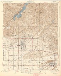
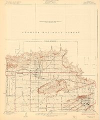 1927 Glendora1927 Print · USGSThe citrus-growing region of eastern Los Angeles County is captured here in the late twenties, showing the intersection of agricultural wealth and new mountain management. Genealogists and researchers can trace property lines near Glendora and San Dimas using landmarks like Citrus Union High School and the Pacific Electric rail line.2 unique versions available
 - 1928 Map of La Verne
 1928 La Verne1928 Print · USGSIn the mid-1920s, the foothill communities east of Los Angeles were emerging from their agricultural roots into structured townsites. Researchers can trace the early Pacific Electric rail lines and locate local landmarks such as Bonita High School and the Cem in La Verne.2 unique versions available
 - 1933 Map of Glendora
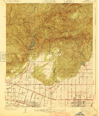
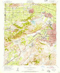
 1933 Glendora1933 Print · USGSThe San Gabriel Mountains come into focus during the early 1930s as vital water infrastructure begins to reshape the canyons. Researchers can trace early engineering feats at Morris Dam and Big Dalton Dam or locate the Kelsey Mine.
 - 1933 Map of La Verne and Evey Canyon
 1933 La Verne and Evey Canyon1933 Print · USGSThe northern reaches of the San Gabriel Valley met the mountain wilderness in the early thirties. Trace early forest infrastructure and recreation spots like Wolfskill Camp, the San Dimas Lookout, and the newly constructed San Dimas Dam.
 - 1939 Map of Glendora
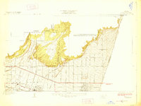
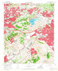
 1939 Glendora1939 Print · USGSThe San Gabriel Valley is captured here during a period of transition between its agricultural roots and suburban growth in the late thirties. Researchers can trace historic rail lines like the Pacific Electric and locate vanished institutions including Carlin Military Academy and Charter Oak.3 unique versions available
 - 1940 Map of La Verne
 1940 La Verne1940 Print · USGSLa Verne and Claremont are captured here just before the mid-century population boom, showing a landscape defined by foothill canyons and early college campuses. Genealogists and historians can trace local landmarks like Scripps College, the Metropolitan Aqueduct, and Wolfskill Camp.4 unique versions available
 - 1953 Map of San Bernardino
 1953 San Bernardino1953 Print · USGSSouthern California underwent massive post-war growth as suburban sprawl reached the foothills of the San Bernardino Mountains. Genealogists and historians can trace the rail-and-road roots of the Inland Empire through the Union Pacific RR and Lake Arrowhead resorts.2 unique versions available
 - 1953 Map of Azusa, 1955 Print
 1953 Azusa1955 Print · USGSThe foothills of the San Gabriel Mountains meet the expanding suburban grids of Monrovia and Azusa during the early fifties. Local historians can trace the paths of the Pacific Electric and AT&SF RR near landmarks like Liveoak Cemetery and Westminster Gardens.2 unique versions available
 - 1953 Map of Glendora, 1955 Print
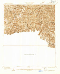
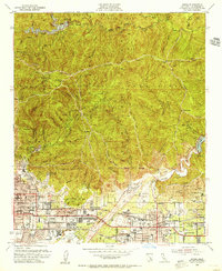
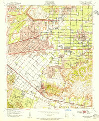
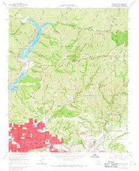
 1953 Glendora1955 Print · USGSThe foothills of the San Gabriel Mountains meet the growing citrus-belt suburbs of Los Angeles County in the early fifties. Researchers can trace early school sites like Wilson Sch and the reach of the San Dimas Experimental Forest.3 unique versions available
 - 1953 Map of Baldwin Park, 1955 Print
 1953 Baldwin Park1955 Print · USGSThe San Gabriel Valley in the mid-fifties is captured here as orange groves and river washes give way to suburban sprawl. Researchers can trace the legacy of local schools and specialized facilities like St Johns School or the Sierra Lodge Sanitarium.2 unique versions available
 - 1954 Map of San Dimas, 1956 Print
 1954 San Dimas1956 Print · USGSEastern Los Angeles County appears at a moment of transition in the mid-fifties as suburban growth begins to surround the area's agricultural roots. Researchers can trace historic schools and cemeteries, from Evergreen Cemetery to the Naval Ordnance Plant and Diamond Bar Ranch.2 unique versions available
 - 1956 Map of San Bernardino
 1956 San Bernardino1956 Print · USGSSouthern California's Inland Empire and High Desert come into focus in the mid-fifties as agriculture gives way to suburban and military growth. Trace early rail lines like the Pacific Electric or find remote landmarks like Camp Rock Mine and George AFB.
 - 1957 Map of San Bernardino
 1957 San Bernardino1957 Print · USGSSouthern California's Inland Empire and High Desert met during the postwar expansion of the late fifties. Genealogists and historians can trace the growth of San Bernardino and Redlands alongside remote landmarks like Edwards AFB and the Camp Rock Mine.
 - 1958 Map of San Bernardino, 1975 Print
 1958 San Bernardino1975 Print · USGSSouthern California’s Inland Empire and High Desert come into focus during the mid-century boom, showing the rise of suburbs and massive military installations. Researchers can trace the rail networks of the Union Pacific RR or locate landmarks like Norton AFB and Big Bear Lake.
 - 1959 Map of San Bernardino
 1959 San Bernardino1959 Print · USGSSouthern California underwent a massive transformation in the late fifties as suburban growth and military power reshaped the desert and valley. Researchers can trace the legacy of the Union Pacific Railroad and locate early footprints of Joshua Tree National Monument and Edwards Air Force Base.
 - 1966 Map of San Bernardino
 1966 San Bernardino1966 Print · USGSThe San Bernardino Valley and Mojave Desert met during a period of massive military and suburban growth in the mid-sixties. Genealogists and historians can trace the development of Edwards Air Force Base, old desert mines like the Bagdad Chase Mine, and mountain communities near Big Bear Lake.
 - 1966 Map of Baldwin Park, 1967 Print
 1966 Baldwin Park1967 Print · USGSThe San Gabriel Valley is captured during its mid-century transition from industrial riverbed to suburban expanse. Researchers can trace the development of La Puente and Covina alongside specialized sites like the El Encanto Sanitarium and Oakdale Memorial Park.5 unique versions available
 - 1966 Map of San Dimas, 1967 Print
 1966 San Dimas1967 Print · USGSThe San Gabriel Valley suburbs were expanding rapidly in the mid-sixties, encircling the high ground of the San Jose Hills. Genealogists and researchers can trace the institutional growth of the era at Cal Poly, Pacific State Hospital, and Sacred Heart Ch.4 unique versions available
 - 1966 Map of Glendora, 1968 Print
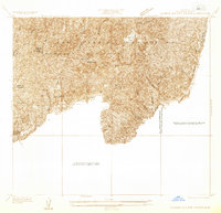
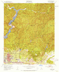
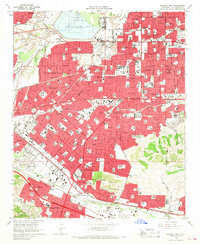
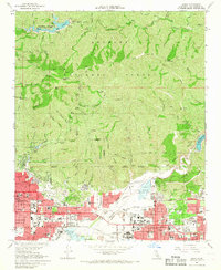
 1966 Glendora1968 Print · USGSThe San Gabriel foothills transitioned from citrus groves to suburban sprawl in the mid-sixties. Researchers can trace the layout of Glendora, the path of the Atchison Topeka and Santa Fe rail line, and the US Naval Ordnance Testing Station on Morris Reservoir.2 unique versions available
 - 1966 Map of Azusa, 1968 Print
 1966 Azusa1968 Print · USGSThe San Gabriel Valley was rapidly suburbanizing in the mid-1960s as residential tracts filled the space between old rail lines and the mountains. You can trace the growth of local institutions like Azusa Pacific College and the City of Hope National Medical Center near Irwindale.5 unique versions available
 - 1976 Map of Azusa
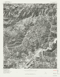 1976 Azusa1976 Print · USGSCovers Glendora, including Azusa, Monrovia, and other nearby areas
 - 1982 Map of San Bernardino, 1983 Print
 1982 San Bernardino1983 Print · USGSThe Inland Empire and San Gabriel Valley met at a peak of suburban and industrial expansion in the early eighties. Researchers can trace the massive rail infrastructure through Cajon Pass and locate landmarks like Norton Air Force Base or the Fontana International Raceway.
Showing maps 1-25 of 27
Top cities near Glendora
- Ontario historical maps
- Rancho Cucamonga historical maps
- Pomona historical maps
- Pasadena historical maps
- Fullerton historical maps
- El Monte historical maps
See more
Top neighborhoods of Glendora
Frequently asked questions
- What are the different types of historical maps available for Glendora?
- What is the oldest map of Glendora?
- Where can I purchase historical maps of Glendora for my home or office?
- Where can I download high-res historical maps of Glendora?
- Are there historical topographic maps available for Glendora?
- Is there historical aerial imagery available for Glendora?
- Where are historical maps of Glendora sourced from?