1930s Maps of Long Beach, California
Explore 3 historic maps of Long Beach from the 1930s. These maps offer a rare glimpse into what life looked like during the 1930s — showing old roads, neighborhoods, homes, and landmarks that have changed or disappeared over time.
Whether you're researching your family's past, planning a metal detecting trip, or studying how Long Beach's landscape evolved across the 1930s, these high-resolution maps are a powerful tool for exploring the history of this region.
- Focus on a specific era: All maps on this page are from the 1930s, giving you a focused view of this time period.
- See what’s changed: Compare century-old streets, trails, and buildings to today's modern landscape using overlays and satellite layers.
- Research with precision: Use these maps for genealogy, historical research, land use analysis, or educational projects.
- View, download, or print: Maps are fully viewable online in high resolution, and can be downloaded or printed for your own records.
Start exploring Long Beach's history through authentic maps from the 1930s. This is your window into the past.
Long Beach, CA maps
(3)- 1930 Map of Compton
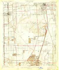 1930 Compton1930 Print · USGSThe South Bay and Gateway regions emerge as industrial powerhouses in this 1930s survey of the plains between Los Angeles and the coast. Trace the footprint of early oil operations at the Shell Oil Dominguez Refinery or locate community roots at the Gardena Japanese School and Woodlawn Cemetery.2 unique versions available
 - 1935 Map of Los Alamitos
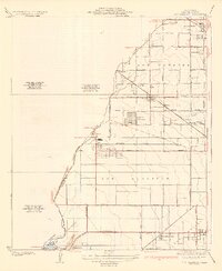 1935 Los Alamitos1935 Print · USGSOrange County's coastal plain is captured in the mid-thirties as rural ranch lands began to yield to industrial expansion. Genealogists and researchers can trace early settlements like Los Alamitos and Buena Park or locate landmarks like the Texas Oil Tank Farm.2 unique versions available
 - 1935 Map of Seal Beach
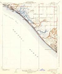 1935 Seal Beach1935 Print · USGSThe Orange County coast in the mid-thirties remains a landscape of sprawling salt marshes and private gun clubs. Trace the early shorefront at Sunset Beach or locate historic markers like Anaheim Landing and the Springdale Sch.3 unique versions available
End of results
Showing maps 1-3 of 3
Top cities near Long Beach
- Los Angeles historical maps
- Anaheim historical maps
- Santa Ana historical maps
- Huntington Beach historical maps
- Garden Grove historical maps
- Torrance historical maps
See more
Top neighborhoods of Long Beach
- Cota historical maps
- Willowville historical maps
- Los Altos historical maps
- North Long Beach historical maps
- Naples historical maps
- Vista del Mar historical maps
See more
Frequently asked questions
- What are the different types of historical maps available for Long Beach?
- What is the oldest map of Long Beach?
- Where can I purchase historical maps of Long Beach for my home or office?
- Where can I download high-res historical maps of Long Beach?
- Are there historical topographic maps available for Long Beach?
- Is there historical aerial imagery available for Long Beach?
- Where are historical maps of Long Beach sourced from?