1960s Maps of Long Beach, California
Explore 5 historic maps of Long Beach from the 1960s. These maps offer a rare glimpse into what life looked like during the 1960s — showing old roads, neighborhoods, homes, and landmarks that have changed or disappeared over time.
Whether you're researching your family's past, planning a metal detecting trip, or studying how Long Beach's landscape evolved across the 1960s, these high-resolution maps are a powerful tool for exploring the history of this region.
- Focus on a specific era: All maps on this page are from the 1960s, giving you a focused view of this time period.
- See what’s changed: Compare century-old streets, trails, and buildings to today's modern landscape using overlays and satellite layers.
- Research with precision: Use these maps for genealogy, historical research, land use analysis, or educational projects.
- View, download, or print: Maps are fully viewable online in high resolution, and can be downloaded or printed for your own records.
Start exploring Long Beach's history through authentic maps from the 1960s. This is your window into the past.
Long Beach, CA maps
(5)- 1960 Map of Long Beach
 1960 Long Beach1960 Print · USGSCoastal California at the height of post-war expansion reveals a dense network of suburban growth and maritime industry. Trace the development of the South Bay and inland neighborhoods like Lakewood Village, or explore the topography of Santa Catalina Island and Los Angeles Harbor.2 unique versions available
 - 1964 Map of Los Alamitos, 1966 Print
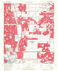 1964 Los Alamitos1966 Print · USGSThe Los Angeles and Orange County borderlands thrive during the mid-sixties suburban boom, characterized by massive military installations and new residential tracts. Researchers can locate vanished landmarks and early neighborhood layouts from Dairy Valley to Barber City, alongside the Naval Air Station Los Alamitos.4 unique versions available
 - 1964 Map of South Gate, 1966 Print
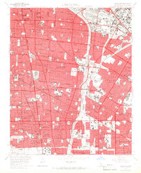 1964 South Gate1966 Print · USGSSoutheast Los Angeles County comes into focus in the mid-1960s, showing a landscape of mature suburbs and heavy rail corridors. Trace the development of local neighborhoods through sites like the Angeles Abbey Mausoleum, Old Downey Cemetery, and the Lynwood Station.4 unique versions available
 - 1964 Map of Long Beach, 1966 Print
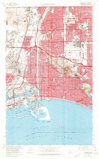 1964 Long Beach1966 Print · USGSCoastal Los Angeles County entered the mid-sixties as a powerhouse of oil production and naval activity. Researchers can trace the mid-century layout of Long Beach, the expansive Long Beach Municipal Airport, and residential areas like Bixby Knolls and Naples.5 unique versions available
 - 1965 Map of Seal Beach, 1967 Print
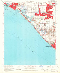 1965 Seal Beach1967 Print · USGSCoastal Orange County undergoes significant postwar development during the mid-sixties, from the massive U S Naval Weapons Station to the developing shore. Trace local history through Meadowlark Airport, the Southern Pacific railroad, and neighborhood schools like McGaugh Sch.3 unique versions available
End of results
Showing maps 1-5 of 5
Top cities near Long Beach
- Los Angeles historical maps
- Anaheim historical maps
- Santa Ana historical maps
- Huntington Beach historical maps
- Garden Grove historical maps
- Torrance historical maps
See more
Top neighborhoods of Long Beach
- Cota historical maps
- Willowville historical maps
- Los Altos historical maps
- North Long Beach historical maps
- Naples historical maps
- Vista del Mar historical maps
See more
Frequently asked questions
- What are the different types of historical maps available for Long Beach?
- What is the oldest map of Long Beach?
- Where can I purchase historical maps of Long Beach for my home or office?
- Where can I download high-res historical maps of Long Beach?
- Are there historical topographic maps available for Long Beach?
- Is there historical aerial imagery available for Long Beach?
- Where are historical maps of Long Beach sourced from?