1920s Maps of Madera County, California
Explore 21 historic maps of Madera County from the 1920s. These maps offer a rare glimpse into what life looked like during the 1920s — showing old roads, neighborhoods, homes, and landmarks that have changed or disappeared over time.
Whether you're researching your family's past, planning a metal detecting trip, or studying how Madera County's landscape evolved across the 1920s, these high-resolution maps are a powerful tool for exploring the history of this region.
- Focus on a specific era: All maps on this page are from the 1920s, giving you a focused view of this time period.
- See what’s changed: Compare century-old streets, trails, and buildings to today's modern landscape using overlays and satellite layers.
- Research with precision: Use these maps for genealogy, historical research, land use analysis, or educational projects.
- View, download, or print: Maps are fully viewable online in high resolution, and can be downloaded or printed for your own records.
Start exploring Madera County's history through authentic maps from the 1920s. This is your window into the past.
Madera County, CA maps
(21)- 1920 Map of Santa Rita Bridge
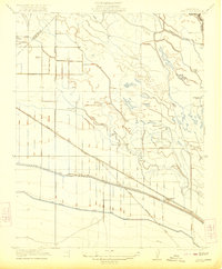
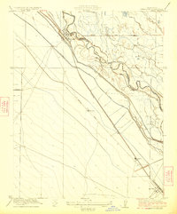
 1920 Santa Rita Bridge1920 Print · USGSThe central San Joaquin Valley appears here as an intricate network of waterways and early ranching outposts just after the turn of the century. Researchers can trace the legacy of large land holdings like Santa Rita Ranch and find specific sites like the Temple Gun Club or Lucerne Farm.
 - 1920 Map of Kismet
 1920 Kismet1920 Print · USGSMadera County’s rail-and-river geography is on full display here during the early twentieth century. Genealogists and researchers can trace the junction of the Atchison Topeka and Santa Fe at Kismet, the rural Talbot School, and the course of the Fresno River.
 - 1920 Map of Bonita Ranch
 1920 Bonita Ranch1920 Print · USGSMadera County agricultural land is captured here in the years following the Great War, showing a landscape defined by ranching and the Fresno River. Genealogists and historians can trace early water rights and property lines at Bonita Ranch and Rattlesnake Ranch.
 - 1921 Map of Daulton
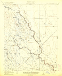
 1921 Daulton1921 Print · USGSMadera County ranching and timber industries are in full operation during the early twenties, connected by a network of flumes and stage roads. Researchers can trace the legacy of local landmarks like the Buchanan Mine, the Dennis School, and the historic Adobe Ranch.
 - 1921 Map of Bullard
 1921 Bullard1921 Print · USGSNorth Fresno and the San Joaquin River corridor were undergoing rapid development in the early twenties as the city expanded toward the Madera County line. Genealogists and local historians can trace early neighborhood schools like Lincoln School and rail junctions such as Biola Junction or the Fresno Interurban.
 - 1921 Map of Mendota
 1921 Mendota1921 Print · USGSAgricultural ranching and water management define this Fresno County landscape in the early twenties. Genealogists and historians can trace the specific boundaries of White House Ranch and Columbia Ranch or locate early industrial sites like Aliso Mill.
 - 1921 Map of Bonita Ranch
 1921 Bonita Ranch1921 Print · USGSIn the early twentieth century, this Madera County landscape was defined by the winding Fresno River and large pastoral holdings. Genealogists and local historians can trace the foundations of the regional ranching economy through landmarks like Bonita Ranch, Rattlesnake Ranch, and the path of Firebaugh Road.
 - 1922 Map of Oxalis
 1922 Oxalis1922 Print · USGSThe Fresno and Merced borderlands are captured here in the early twenties during a period of significant irrigation and ranching expansion. Local historians can trace the foundations of the regional economy through the San Joaquin River canals and operations like Hog Ranch and Oxalis.3 unique versions available
 - 1922 Map of Santa Rita Bridge
 1922 Santa Rita Bridge1922 Print · USGSThe braided channels of the San Joaquin Valley are captured here in the early twentieth century, showing a landscape of sprawling ranches and water rights. Genealogists and historians can trace old property lines and river crossings like Santa Rita Bridge, Santa Rita Ranch, and the Temple Gun Club.2 unique versions available
 - 1922 Map of Lanes Bridge
 1922 Lanes Bridge1922 Print · USGSThe San Joaquin River valley at the Madera-Fresno county line comes to life in this early 1920s survey. Historians can trace the rural landscape through landmarks like Deep Well School, the crossing at Lanes Bridge, and the Little Table Mountain foothills.
 - 1922 Map of Friant
 1922 Friant1922 Print · USGSFresno County at the edge of the Sierra foothills is captured here during the heyday of the railroad and early copper mining. Researchers can trace the legacy of rural education at Pollasky School or locate the Fresno Copper Mine and Gordon Siding.2 unique versions available
 - 1922 Map of Gregg
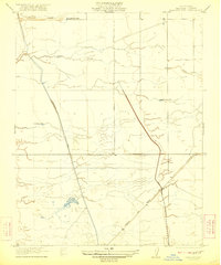
 1922 Gregg1922 Print · USGSMadera County’s agricultural heartland is captured in the early 1920s as a landscape defined by competing rail lines and seasonal creeks. Genealogists and local historians can trace the early rail junctions at Trigo and Gregg or locate the rural Service School.
 - 1922 Map of Pozo Farm
 1922 Pozo Farm1922 Print · USGSThe San Joaquin River and its complex system of canals define the Madera and Fresno county line in the early 1920s. Researchers can trace early irrigation at Pozo Farm or locate landmarks like the Rasin City Gun Club and the Southern Pacific rail line.2 unique versions available
 - 1922 Map of Kentucky Well
 1922 Kentucky Well1922 Print · USGSMadera County ranching and water history come into focus in the early 1920s as the Central Valley's irrigation network expanded. Local historians and genealogists can trace the early path of the Madera and Firebaugh Road and locate historic watering spots like Kentucky Well and Colombia Well.2 unique versions available
 - 1922 Map of Madera
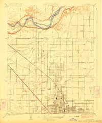
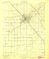 1922 Madera1922 Print · USGSMadera and the surrounding valley floor are captured here in the early twenties, during a period of significant agricultural and infrastructure development. Genealogists and local historians can locate early landmarks like Italian Swiss Colony, the County Hospital, and rural schoolhouses including Lavine School and Arcola School.
 - 1923 Map of Herndon
 1923 Herndon1923 Print · USGSCentral California's agricultural landscape comes into focus in the early twenties as the grid of Fresno County takes shape. Trace the early rail stops at Herndon, Barstow, and Dickerson along the San Joaquin River and major lines.2 unique versions available
 - 1923 Map of Firebaugh
 1923 Firebaugh1923 Print · USGSThe San Joaquin Valley comes alive in the early twenties as irrigation canals and rail lines transformed the Fresno and Madera county line. Genealogists and historians can trace old homesteads and transit stops like Arbios, Helm Ranch, and Mendota along the Southern Pacific tracks.
 - 1923 Map of Biola
 1923 Biola1923 Print · USGSThe San Joaquin Valley landscape is defined here by its early irrigation-age grid and river crossings in the early twenties. Genealogists can trace family footprints near Biola or locate rural landmarks like Vineland School, Skaggs Bridge, and Kerman High School.
 - 1923 Map of Bullard
 1923 Bullard1923 Print · USGSNorthern Fresno and the San Joaquin River corridor are captured here during the 1920s as the city expanded into the surrounding orchard lands. Researchers can trace early rail lines like the Fresno Interurban or locate family landmarks such as Bullard School and McKinley School.
 - 1924 Map of Gravelly Ford
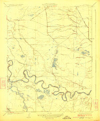
 1924 Gravelly Ford1924 Print · USGSThe San Joaquin Valley at the height of its early irrigation boom reveals a landscape of cattle camps and emerging citrus and grain fields. Trace the river crossing at Gravelly Ford and locate local landmarks like the Sunset School and Gravelly Ford Ranch.
 - 1924 Map of Mendota
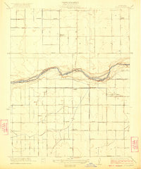
 1924 Mendota1924 Print · USGSAgricultural development in the Central Valley reached a turning point in the early twentieth century as irrigation canals reshaped the land. Trace the early boundaries of Columbia Ranch, the town of Mendota, and the original course of the San Joaquin River.2 unique versions available
End of results
Showing maps 1-21 of 21
Top cities of Madera County
Frequently asked questions
- What are the different types of historical maps available for Madera County?
- What is the oldest map of Madera County?
- Where can I purchase historical maps of Madera County for my home or office?
- Where can I download high-res historical maps of Madera County?
- Are there historical topographic maps available for Madera County?
- Is there historical aerial imagery available for Madera County?
- Where are historical maps of Madera County sourced from?