1940s Maps of Madera County, California
Explore 55 historic maps of Madera County from the 1940s. These maps offer a rare glimpse into what life looked like during the 1940s — showing old roads, neighborhoods, homes, and landmarks that have changed or disappeared over time.
Whether you're researching your family's past, planning a metal detecting trip, or studying how Madera County's landscape evolved across the 1940s, these high-resolution maps are a powerful tool for exploring the history of this region.
- Focus on a specific era: All maps on this page are from the 1940s, giving you a focused view of this time period.
- See what’s changed: Compare century-old streets, trails, and buildings to today's modern landscape using overlays and satellite layers.
- Research with precision: Use these maps for genealogy, historical research, land use analysis, or educational projects.
- View, download, or print: Maps are fully viewable online in high resolution, and can be downloaded or printed for your own records.
Start exploring Madera County's history through authentic maps from the 1940s. This is your window into the past.
Madera County, CA maps
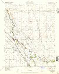
(55)- 1941 Map of Firebaugh
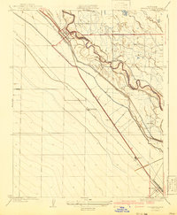 1941 Firebaugh1941 Print · USGSFresno and Madera counties are shown here just before the mid-century, defined by the irrigation canals and rail lines of the Central Valley. Researchers can trace the industrial footprint of the Standard Oil Pump Station and family landmarks like Helm Ranch.
 - 1942 Map of Raymond
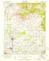
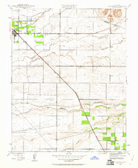
 1942 Raymond1942 Print · USGSMadera County ranching and mining operations are captured here during the early 1940s as the foothills transitioned from wilderness to industry. Researchers can trace the Southern Pacific rail line to Raymond or locate the Daulton Copper Mine and Savage Monument.
 - 1942 Map of Athlone
 1942 Athlone1942 Print · USGSThe Merced and Madera county line area is shown here in the early 1940s as agricultural irrigation and rail transport defined the region. Genealogists can locate family-named landmarks like Bliss Ranch and several rural schoolhouses including Alamo Sch and Pioneer Sch.
 - 1942 Map of Daulton, 1954 Print
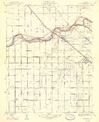
 1942 Daulton1954 Print · USGSMadera County ranching country is captured here in the early 1940s as the Fresno River and Southern Pacific railroad shaped local life. Researchers can locate historic rural stops like Sixmile House, the Adobe Ranch, and Hensley Bridge.
 - 1942 Map of Little Table Mountain, 1954 Print
 1942 Little Table Mountain1954 Print · USGSMadera County ranching country is captured here in the early 1940s, showing the foothill landscape before modern development. Genealogists can locate family landmarks like Shannon Ranch, the Wide Awake Ranch, and the rural Marysdale School.
 - 1942 Map of Millerton Lake, 1959 Print
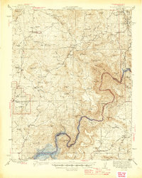
 1942 Millerton Lake1959 Print · USGSThe foothills of Madera and Fresno counties come alive in the 1940s as the San Joaquin River is transformed by the Friant Dam. Genealogists and historians can locate family homesteads like Rosedale Ranch and early rural institutions including Spring Valley Sch and Picayune Rancheria.2 unique versions available
 - 1944 Map of Raymond
 1944 Raymond1944 Print · USGSMadera County ranching and mining operations are captured in detail during the early 1940s, just as the regional economy transitioned. Genealogists and historians can trace family landmarks like Sixmile House and Bates Station, or locate the Daulton Copper Mine and Union High School.2 unique versions available
 - 1945 Map of Millerton Lake
 1945 Millerton Lake1945 Print · USGSThe Madera and Fresno County foothills come alive in the 1940s, showing the early years of Millerton Lake and the San Joaquin River gorge. Genealogists and historians can locate remote family sites like Venter and Hildreth, alongside the Picayune Rancheria and Walker Cemetery.2 unique versions available
 - 1946 Map of Friant, 1947 Print
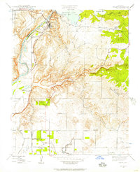 1946 Friant1947 Print · USGSThe San Joaquin River frontier was being reshaped by industrial engineering in the late 1940s. Genealogists and historians can trace the foundations of the regional water system at Friant Dam and find local landmarks like Gordon, Millerton Sch, and the Southern Pacific rail line.
 - 1946 Map of Le Grand, 1953 Print
 1946 Le Grand1953 Print · USGSThe San Joaquin Valley agricultural heartland comes into focus during the mid-forties, showing the vital rail corridors and watercourses that shaped the region. Genealogists and local researchers can trace early settlements and rural school sites like Dixieland School, Fairmead, and the northern hub of Le Grand.2 unique versions available
 - 1946 Map of Firebaugh, 1954 Print
 1946 Firebaugh1954 Print · USGSThe Central Valley ranching and rail corridor comes to life in the mid-1940s as irrigation projects began reshuffling the landscape. Trace the Southern Pacific line through Firebaugh and Mendota, or locate family-named sites like Helm Ranch and Arbios.2 unique versions available
 - 1946 Map of Madera, 1954 Print
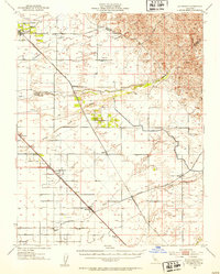
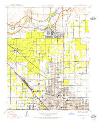
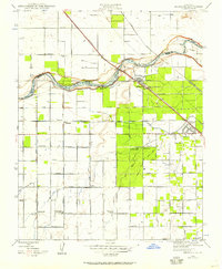
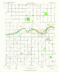
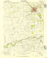 1946 Madera1954 Print · USGSMadera and the surrounding valley floor are shown in the mid-1940s as the regional irrigation network reached its height. Researchers can trace the development of rural education and transport at Storey, Ripperdan School, and the Empire RR.2 unique versions available
 - 1946 Map of Santa Rita Park, 1954 Print
 1946 Santa Rita Park1954 Print · USGSThe San Joaquin Valley's intricate network of sloughs and early irrigation canals is captured here as the ranching economy thrived after the war. Family historians can trace dozens of named estates and local landmarks like Santa Rita Park, Lone Tree Sch, and Wolfsen Mill.
 - 1946 Map of Clovis, 1955 Print
 1946 Clovis1955 Print · USGSPost-war Fresno County comes to life as the newly completed Friant Dam transforms the valley landscape. Trace the origins of irrigation at Friant-Kern Canal or locate family landmarks like Hammer Field and Nees Colony Sch.
 - 1946 Map of Fresno North, 1955 Print
 1946 Fresno North1955 Print · USGSNorthern Fresno and the San Joaquin River corridor appear here in the mid-1940s as the city expands toward the Madera County line. Researchers can trace the development of Camp Pinedale, the Army Air Forces Depot, and early neighborhoods near Figarden.
 - 1946 Map of Lanes Bridge, 1957 Print
 1946 Lanes Bridge1957 Print · USGSMadera and Fresno Counties come together along the river during the mid-forties, showing a landscape of rural schools and winding waterways. Genealogists and local historians can trace the foundations of Lanes Bridge and locate landmarks like Webster Sch or Fort Washington Sch.
 - 1946 Map of Herndon, 1957 Print
 1946 Herndon1957 Print · USGSThe San Joaquin Valley landscape in the mid-1940s shows a thriving agricultural region defined by massive irrigation projects and rail transit. Genealogists and historians can trace local school districts like Teague Sch or follow the early footprints of Barstow and Highway City.
 - 1946 Map of Bonita Ranch, 1960 Print
 1946 Bonita Ranch1960 Print · USGSMadera County ranching and irrigation patterns are clearly visible in this mid-century survey of the Central Valley. Researchers can trace the legacy of large operations like Bonita Ranch and the alignment of the Gravelly Ford Canal (Abandoned).
 - 1946 Map of Le Grand, 1961 Print
 1946 Le Grand1961 Print · USGSLe Grand and the surrounding Central Valley ranch lands are captured here just after the war as the region's agricultural footprint matured. Researchers can trace the path of the Atchison Topeka and Santa Fe through Le Grand and Marguerite, or locate early industrial sites like the Gravel Pit near Mariposa Creek.
 - 1946 Map of Gravelly Ford, 1962 Print
 1946 Gravelly Ford1962 Print · USGSThe central San Joaquin Valley comes into focus just after the war as irrigation networks transformed the landscape. Researchers can trace historic water rights and ranching boundaries through the Gravelly Ford Ranch, Sunset Sch, and the Enterprise Canal.
 - 1946 Map of Gregg, 1962 Print
 1946 Gregg1962 Print · USGSMadera County agricultural lands and rail corridors are captured here in the mid-1940s. Genealogists and researchers can trace rural life through the Sweet Flower Sch and the tracks of the Southern Pacific and Atchison Topeka and Santa Fe.
 - 1946 Map of Biola, 1963 Print
 1946 Biola1963 Print · USGSThe San Joaquin Valley's agricultural heartland is captured here just after the war, showing the expansion of irrigation and rural education. Genealogists can locate family sites near Bethany Cem or trace the early days of Kerman High Sch and Biola.2 unique versions available
 - 1947 Map of Bonita Ranch
 1947 Bonita Ranch1947 Print · USGSMadera County agricultural life is captured here in the mid-forties, showing the vast ranching and irrigation network of the San Joaquin Valley. Genealogists and researchers can trace local landmarks like Bonita Ranch, the Fresno River, and the Gravelly Ford Canal (Abandoned).
 - 1947 Map of Herndon
 1947 Herndon1947 Print · USGSNorth of Fresno after the war, this area was a busy corridor of rail transit and irrigation-fed ranching along the San Joaquin River. Genealogists can trace a network of rural school districts including Pershing and Central Union High Sch, alongside early settlements like Barstow and Highway City.2 unique versions available
 - 1947 Map of Gregg
 1947 Gregg1947 Print · USGSMadera County agricultural life is captured here in the late 1940s, as the Central Valley transitioned into a post-war farming powerhouse. Genealogists and historians can trace the rail sidings at Trigo, the location of Sweet Flower Sch, and the path of the Southern Pacific.
Showing maps 1-25 of 55
Top cities of Madera County
Frequently asked questions
- What are the different types of historical maps available for Madera County?
- What is the oldest map of Madera County?
- Where can I purchase historical maps of Madera County for my home or office?
- Where can I download high-res historical maps of Madera County?
- Are there historical topographic maps available for Madera County?
- Is there historical aerial imagery available for Madera County?
- Where are historical maps of Madera County sourced from?