1910s Maps of Madera County, California
Explore 13 historic maps of Madera County from the 1910s. These maps offer a rare glimpse into what life looked like during the 1910s — showing old roads, neighborhoods, homes, and landmarks that have changed or disappeared over time.
Whether you're researching your family's past, planning a metal detecting trip, or studying how Madera County's landscape evolved across the 1910s, these high-resolution maps are a powerful tool for exploring the history of this region.
- Focus on a specific era: All maps on this page are from the 1910s, giving you a focused view of this time period.
- See what’s changed: Compare century-old streets, trails, and buildings to today's modern landscape using overlays and satellite layers.
- Research with precision: Use these maps for genealogy, historical research, land use analysis, or educational projects.
- View, download, or print: Maps are fully viewable online in high resolution, and can be downloaded or printed for your own records.
Start exploring Madera County's history through authentic maps from the 1910s. This is your window into the past.
Madera County, CA maps
(13)- 1912 Map of Mariposa
 1912 Mariposa1912 Print · USGSThe California Sierra foothills in the early twentieth century are mapped here as a hive of mining and timber activity. Researchers can trace the legacy of remote settlements and family lands including Grub Gulch, the Indian Settlement, and Knowles.6 unique versions available
 - 1913 Map of Panoche
 1913 Panoche1913 Print · USGSThe San Joaquin Valley and its ranching foothills appear in the early twentieth century before modern expansion. Genealogists can find remote rural schools and outposts like Mercy School, Laguna Seca Ranch, and the Mercy Mine.4 unique versions available
 - 1916 Map of Berenda
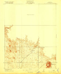
 1916 Berenda1916 Print · USGSMadera County agricultural life is captured here in the years before the Great War, showing a landscape organized by rail and road. Family historians can locate early farmstead sites near Berendo School, Fairmead, and the Crumley settlement.
 - 1916 Map of Santa Rita Bridge, 1948 Print
 1916 Santa Rita Bridge1948 Print · USGSThe San Joaquin River valley was a landscape of ambitious ranching and irrigation in the mid-1940s. Genealogists and local historians can trace legacy holdings like Wolfsen Mill, Belmont Ranch, and Temple Ranch across this three-county border region.2 unique versions available
 - 1916 Map of Sulphur Springs, 1959 Print
 1916 Sulphur Springs1959 Print · USGSThe canyon lands of the Sierra foothills appear here as they were before the creation of Millerton Lake. Researchers can trace the original riverbanks and historic sites like Old Millerton, Old Fort Miller, and Belleview.2 unique versions available
 - 1918 Map of Bliss Ranch
 1918 Bliss Ranch1918 Print · USGSIn the San Joaquin Valley during the late teens, these ranchlands were being reshaped by early water management and survey grids. Genealogists can trace the footprint of the Chowchilla and Bliss Ranch along the Baxter Feeding Canal.2 unique versions available
 - 1918 Map of Chowchilla
 1918 Chowchilla1918 Print · USGSCentral California farmland comes into focus at the end of the Great War, showing a landscape defined by new rail-towns and irrigation. Trace the development of Chowchilla and small settlements like Tillman, Lincoln, and Dairyland.
 - 1918 Map of Berenda
 1918 Berenda1918 Print · USGSMadera County agricultural lands and rail junctions are captured here in the years following the first World War. Genealogists and researchers can trace early homestead patterns around Fairmead, Berenda, and the Munich School.
 - 1918 Map of La Grand
 1918 La Grand1918 Print · USGSAgricultural life in the San Joaquin Valley comes into focus just before the 1920s, dominated by the railroad and a network of Sierra-fed creeks. You can trace the early rail stops at Dickinson and Marguerite or locate rural landmarks like Appling School and the Chowchilla River.
 - 1919 Map of Sulphur Springs
 1919 Sulphur Springs1919 Print · USGSThe San Joaquin River foothills appear at a crossroads during the late teens, just as the regional landscape began to modernize. Researchers can locate the early sites of Old Fort Miller and Old Millerton or trace the winding Friant and O'neals Road.2 unique versions available
 - 1919 Map of Plainsberg
 1919 Plainsberg1919 Print · USGSThe Central Valley's agricultural and rail heartland is captured here just after the Great War, showing a landscape defined by seasonal sloughs and early highways. Genealogists can locate family sites near Savanna School or early transit hubs like Plainsberg and Minturn.
 - 1919 Map of Raynor Creek
 1919 Raynor Creek1919 Print · USGSThe foothills of Madera and Merced counties appear here during the early twentieth century, showing a landscape shaped by seasonal waterways and early political borders. Researchers can trace the path of the Chowchilla River and the precise location of the Boundary Line separating Madera Co from its neighbors.
 - 1919 Map of Little Table Mountain
 1919 Little Table Mountain1919 Print · USGSMadera County ranch lands come into focus in the years before the Great War, showing a network of early cattle trails and rural outposts. Researchers can trace the location of the Marysdale School and family operations like the Wide Awake Ranch.2 unique versions available
End of results
Showing maps 1-13 of 13
Top cities of Madera County
Frequently asked questions
- What are the different types of historical maps available for Madera County?
- What is the oldest map of Madera County?
- Where can I purchase historical maps of Madera County for my home or office?
- Where can I download high-res historical maps of Madera County?
- Are there historical topographic maps available for Madera County?
- Is there historical aerial imagery available for Madera County?
- Where are historical maps of Madera County sourced from?