1980s Maps of Madera County, California
Explore 12 historic maps of Madera County from the 1980s. These maps offer a rare glimpse into what life looked like during the 1980s — showing old roads, neighborhoods, homes, and landmarks that have changed or disappeared over time.
Whether you're researching your family's past, planning a metal detecting trip, or studying how Madera County's landscape evolved across the 1980s, these high-resolution maps are a powerful tool for exploring the history of this region.
- Focus on a specific era: All maps on this page are from the 1980s, giving you a focused view of this time period.
- See what’s changed: Compare century-old streets, trails, and buildings to today's modern landscape using overlays and satellite layers.
- Research with precision: Use these maps for genealogy, historical research, land use analysis, or educational projects.
- View, download, or print: Maps are fully viewable online in high resolution, and can be downloaded or printed for your own records.
Start exploring Madera County's history through authentic maps from the 1980s. This is your window into the past.
Madera County, CA maps
(12)- 1980 Map of Shaver Lake
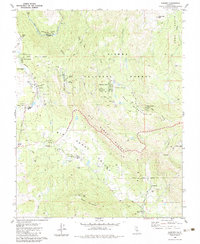
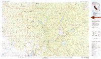 1980 Shaver Lake1980 Print · USGSThe Sierra Nevada foothills and high country come into focus during the early eighties, showing the region's complex water and timber infrastructure. Researchers can trace the heritage of local industry at Knowles Quarry, Buchanan Mine, and the hydroelectric works around Big Creek.3 unique versions available
 - 1982 Map of Balloon Dome
 1982 Balloon Dome1982 Print · USGSHigh-country wilderness in the early eighties defines the border of Madera and Fresno counties. Trace old trail routes and backcountry infrastructure from Balloon Dome to the Heitz Meadow Forest Service Station and the Lookout Tower on Mount Tom.2 unique versions available
 - 1982 Map of Cascadel Point, 1983 Print
 1982 Cascadel Point1983 Print · USGSIn the early eighties, the San Joaquin River canyon was a hub of hydroelectric power and mountain settlement. Genealogists and historians can trace the community around Chawanakee Sch, the residential layout of Cascadel Woods, and old roads like Italian Bar Road.
 - 1982 Map of Fresno, 1983 Print
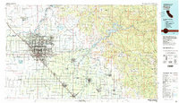 1982 Fresno1983 Print · USGSThe San Joaquin Valley's agricultural and urban landscape is captured here in the early eighties as Fresno expanded northward. Researchers can trace the rail lines of the Southern Pacific RR and identify landmarks like Raisin City and Kingsburg.2 unique versions available
 - 1982 Map of Mendota, 1983 Print
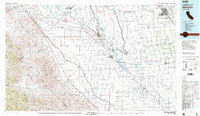 1982 Mendota1983 Print · USGSThe Central Valley's massive water-moving infrastructure is in full view during the early eighties, from the San Joaquin River to the California Aqueduct. Researchers can trace the Southern Pacific rail lines through towns like Mendota, Firebaugh, and Tranquillity.2 unique versions available
 - 1982 Map of Musick Mtn, 1983 Print
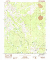
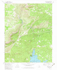 1982 Musick Mtn1983 Print · USGSThe High Sierra hydroelectric and timber landscape comes into focus in the early eighties as powerhouses and forest stations dot the rugged terrain. Researchers can trace the Old Railroad Grade, locate the Musick Mountain Lookout, and explore settlements like Camp Sierra.2 unique versions available
 - 1983 Map of Auberry
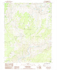
 1983 Auberry1983 Print · USGSThe Fresno County foothills come into focus in the early eighties as the community of Auberry expanded into New Auberry. Local historians can trace the Big Sandy Rancheria, the Auberry Indian Mission, and rural schools like Sierra Sch.
 - 1983 Map of Merced
 1983 Merced1983 Print · USGSThe San Joaquin Valley at the start of the eighties is captured here in its full agricultural and military height. Trace the legacy of Castle Air Force Base, old mines like Pocahontas Mine, and the vast Kesterson National Wildlife Refuge.
 - 1983 Map of Mt. Ritter, 1984 Print
 1983 Mt. Ritter1984 Print · USGSThe high Sierra crest at the Madera and Mono county line is documented here during the early eighties. Hikers and historians can trace the classic routes of the John Muir Trail and Pacific Crest National Scenic Trail past Thousand Island Lake and the Minaret Mine.
 - 1983 Map of Cattle Mtn, 1984 Print
 1983 Cattle Mtn1984 Print · USGSThe high Sierra of Madera County is captured here in the early eighties, showing the remote high-country meadows and wilderness boundaries. Researchers can trace historic backcountry routes through Miller Crossing, Stairway Meadow, and along the Stairway Creek Trail.2 unique versions available
 - 1984 Map of Mammoth Mtn
 1984 Mammoth Mtn1984 Print · USGSThe high Sierra peaks of Mono County are captured in the mid-1980s, showing the established trails and campgrounds of the Inyo National Forest. Researchers can trace the routes of the Pacific Crest National Scenic Trail and locate landmarks like the Devils Postpile and Mammoth Mtn Main Lodge.2 unique versions available
 - 1984 Map of Crystal Crag
 1984 Crystal Crag1984 Print · USGSThe High Sierra backcountry and the iconic Devils Postpile are captured here in the mid-eighties. Trail researchers can trace the paths of the Pacific Crest and John Muir Trail past Rainbow Falls and the remote Iva Bell Hot Springs.
End of results
Showing maps 1-12 of 12
Top cities of Madera County
Frequently asked questions
- What are the different types of historical maps available for Madera County?
- What is the oldest map of Madera County?
- Where can I purchase historical maps of Madera County for my home or office?
- Where can I download high-res historical maps of Madera County?
- Are there historical topographic maps available for Madera County?
- Is there historical aerial imagery available for Madera County?
- Where are historical maps of Madera County sourced from?