1920s Maps of Merced County, California
Explore 17 historic maps of Merced County from the 1920s. These maps offer a rare glimpse into what life looked like during the 1920s — showing old roads, neighborhoods, homes, and landmarks that have changed or disappeared over time.
Whether you're researching your family's past, planning a metal detecting trip, or studying how Merced County's landscape evolved across the 1920s, these high-resolution maps are a powerful tool for exploring the history of this region.
- Focus on a specific era: All maps on this page are from the 1920s, giving you a focused view of this time period.
- See what’s changed: Compare century-old streets, trails, and buildings to today's modern landscape using overlays and satellite layers.
- Research with precision: Use these maps for genealogy, historical research, land use analysis, or educational projects.
- View, download, or print: Maps are fully viewable online in high resolution, and can be downloaded or printed for your own records.
Start exploring Merced County's history through authentic maps from the 1920s. This is your window into the past.
Merced County, CA maps
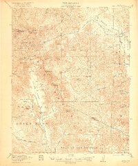
(17)- 1920 Map of Indian Gulch
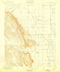
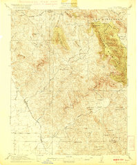 1920 Indian Gulch1920 Print · USGSMariposa County at the height of its early mining and ranching era is captured in this meticulous 1920s-era topographic survey. Researchers can trace family history at the Hornitos School or locate historic claims like the Ruth Pierce Mine and Johnnie Green Mine.3 unique versions available
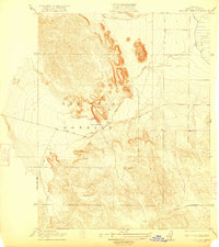
 - 1920 Map of Pacheco Pass
 1920 Pacheco Pass1920 Print · USGSThe Pacheco Pass gateway and the eastern Diablo Range are captured here during the early twentieth century. Researchers can trace historic local life through sites like the Bald Eagle Mine, San Luis Ranch, and Cottonwood School.4 unique versions available
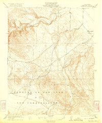
 - 1920 Map of Santa Rita Bridge
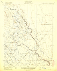
 1920 Santa Rita Bridge1920 Print · USGSThe central San Joaquin Valley appears here as an intricate network of waterways and early ranching outposts just after the turn of the century. Researchers can trace the legacy of large land holdings like Santa Rita Ranch and find specific sites like the Temple Gun Club or Lucerne Farm.
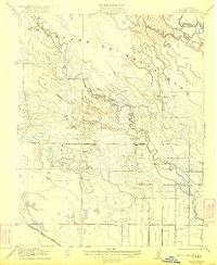
 - 1920 Map of Carrisalito Spring
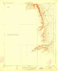
 1920 Carrisalito Spring1920 Print · USGSMerced County's rugged foothills and early oil infrastructure appear in this 1920s survey. Researchers can trace remote landmarks like the Ortigalita School, the Carrisalito Spring, and an early Oil Pump Sta.
 - 1921 Map of Volta
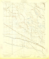
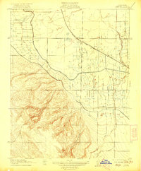 1921 Volta1921 Print · USGSMerced County agriculture and rail transit are in focus during the early twenties as irrigation reshapes the valley floor. Genealogists and historians can locate the Volta rail stop, the rural Monroe School, and the path of the San Joaquin and Kings River Canal.
 - 1921 Map of Los Banos
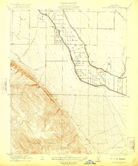
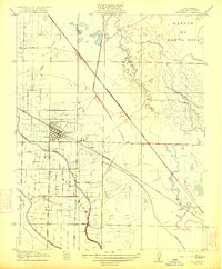 1921 Los Banos1921 Print · USGSLos Banos and the surrounding Merced County ranch lands are captured here during the early twentieth-century expansion of Central Valley irrigation. Family historians and researchers can trace the Southern Pacific rail corridor, the Center School, and rural landings like Abbat and Gudwall.2 unique versions available
 - 1921 Map of Laguna Seca Ranch
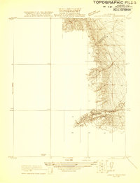 1921 Laguna Seca Ranch1921 Print · USGSThe Fresno and Merced borderlands come into focus in the early 1920s, showing the intersection of these two counties along the foothills. Researchers can trace the winding course of Little Panoche Creek and study the elevation of Merced Co and Fresno Co.
 - 1922 Map of Oxalis
 1922 Oxalis1922 Print · USGSThe Fresno and Merced borderlands are captured here in the early twenties during a period of significant irrigation and ranching expansion. Local historians can trace the foundations of the regional economy through the San Joaquin River canals and operations like Hog Ranch and Oxalis.3 unique versions available
 - 1922 Map of Santa Rita Bridge
 1922 Santa Rita Bridge1922 Print · USGSThe braided channels of the San Joaquin Valley are captured here in the early twentieth century, showing a landscape of sprawling ranches and water rights. Genealogists and historians can trace old property lines and river crossings like Santa Rita Bridge, Santa Rita Ranch, and the Temple Gun Club.2 unique versions available
 - 1922 Map of Charleston School
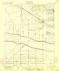
 1922 Charleston School1922 Print · USGSMerced County agriculture was being transformed in the early twenties as irrigation grids expanded across the valley floor. Genealogists and researchers can trace the location of the Charleston School and the path of the San Joaquin and Kings River Canal alongside Swamp Road.2 unique versions available
 - 1922 Map of Dos Palos
 1922 Dos Palos1922 Print · USGSThe San Joaquin Valley comes into focus in the early twenties as irrigation and rail infrastructure transformed the landscape. Map collectors can trace the San Joaquin and Kings River Canal alongside the Old Southern Pacific Grade and the settlement at Oro Loma.2 unique versions available
 - 1922 Map of Quien Sabe
 1922 Quien Sabe1922 Print · USGSThe Diablo Range transitions from rugged peaks to vast historic land grants in the early twentieth century. Researchers can trace remote ranching sites like Buena Vista Ranch, the high-altitude Stayton Mine, and the local Quien Sabe School.4 unique versions available
 - 1922 Map of San Luis Creek
 1922 San Luis Creek1922 Print · USGSThe foothills of the San Joaquin Valley appear in this early twentieth-century survey, just as the ranching era was well-established. Genealogists and historians can trace old property lines through the San Luis Ranch and (Howard Ranch) or follow the path of Pacheco Pass Road.2 unique versions available
 - 1922 Map of Ortigalita
 1922 Ortigalita1922 Print · USGSMerced County in the early twenties shows a landscape of deep creek beds and early industrial footprints. Genealogists and historians can trace the rural community through the Ortigalita School and the remote Oil Pumping Station.2 unique versions available
 - 1922 Map of Delta Ranch
 1922 Delta Ranch1922 Print · USGSMerced County ranching and river lands are captured here in the years following the Great War, showing a landscape defined by water and early land grants. You can trace family ranching roots at Delta Ranch and Midway Ranch, or follow the path of the Old Southern Pacific Grade.2 unique versions available
 - 1922 Map of Howard Ranch
 1922 Howard Ranch1922 Print · USGSThe foothills of the Diablo Range meet the San Joaquin Valley in this early twentieth-century survey. Genealogists and historians can trace rural family life through the locations of the Occidental School, Cottonwood Church, and the historic Howard Ranch.2 unique versions available
 - 1923 Map of Laguna Seca Ranch
 1923 Laguna Seca Ranch1923 Print · USGSRanching and rugged terrain define the Merced and Fresno county line during the early twenties. Genealogists and land historians can trace the early boundaries of Laguna Seca Ranch and the winding course of Little Panoche Creek.3 unique versions available
End of results
Showing maps 1-17 of 17
Top cities of Merced County
- Merced historical maps
- Los Banos historical maps
- Atwater historical maps
- Livingston historical maps
- Delhi historical maps
- Winton historical maps
See more
Frequently asked questions
- What are the different types of historical maps available for Merced County?
- What is the oldest map of Merced County?
- Where can I purchase historical maps of Merced County for my home or office?
- Where can I download high-res historical maps of Merced County?
- Are there historical topographic maps available for Merced County?
- Is there historical aerial imagery available for Merced County?
- Where are historical maps of Merced County sourced from?