1960s Maps of Merced County, California
Explore 54 historic maps of Merced County from the 1960s. These maps offer a rare glimpse into what life looked like during the 1960s — showing old roads, neighborhoods, homes, and landmarks that have changed or disappeared over time.
Whether you're researching your family's past, planning a metal detecting trip, or studying how Merced County's landscape evolved across the 1960s, these high-resolution maps are a powerful tool for exploring the history of this region.
- Focus on a specific era: All maps on this page are from the 1960s, giving you a focused view of this time period.
- See what’s changed: Compare century-old streets, trails, and buildings to today's modern landscape using overlays and satellite layers.
- Research with precision: Use these maps for genealogy, historical research, land use analysis, or educational projects.
- View, download, or print: Maps are fully viewable online in high resolution, and can be downloaded or printed for your own records.
Start exploring Merced County's history through authentic maps from the 1960s. This is your window into the past.
Merced County, CA maps
(54)- 1960 Map of Arena, 1961 Print
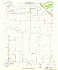
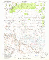
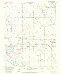
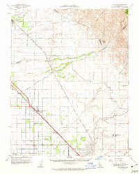
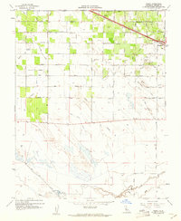 1960 Arena1961 Print · USGSMerced County at the start of the 1960s showcases a landscape transformed by intensive irrigation and the Southern Pacific rail line. Researchers can trace the layout of Arena and early Atwater, alongside specialized features like the Tin Flume and Airstrip.3 unique versions available
 - 1960 Map of Volta, 1961 Print
 1960 Volta1961 Print · USGSMerced County agriculture and irrigation are at their mid-century peak in this survey of the San Joaquin Valley. Genealogists and researchers can trace the Southern Pacific rail line through Volta, locate the Labor Camp, and identify the grounds of the Los Banos Odd Fellows Grove.4 unique versions available
 - 1960 Map of Plainsburg, 1961 Print
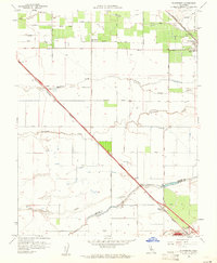 1960 Plainsburg1961 Print · USGSThe San Joaquin Valley's agricultural heartland is captured here at the start of the 1960s, showing a landscape defined by orchards and vital rail corridors. Genealogists and local historians can trace family-named roads and landmarks like Plainsburg, the Savana Sch, and the junction of the Southern Pacific railroad.3 unique versions available
 - 1960 Map of Bliss Ranch, 1961 Print
 1960 Bliss Ranch1961 Print · USGSMadera County ranching and irrigation systems are in full focus during the early sixties. Researchers can trace the boundaries of historic estates like Bliss Ranch and Red Top Ranch while locating community landmarks such as Alamo School and the Labor Camp.3 unique versions available
 - 1960 Map of El Nido, 1961 Print
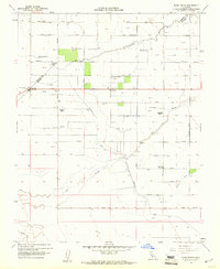
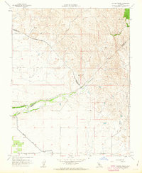
 1960 El Nido1961 Print · USGSMerced County agriculture and irrigation are in full focus at the start of the 1960s. Researchers can trace the Southern Pacific rail line through Lingard, locate the Duck Club, and follow the complex water routes of Deadman Creek and Duck Slough.2 unique versions available
 - 1960 Map of Los Banos, 1961 Print
 1960 Los Banos1961 Print · USGSLos Banos and the surrounding Merced County wetlands are shown here during the early sixties, highlighting a landscape defined by water management and rail. Genealogists can locate family sites near Calvary Cem and trace institutions like West Side Union High School or the Los Banos Game Bird Farm.3 unique versions available
 - 1960 Map of Atwater, 1961 Print
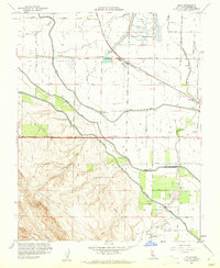
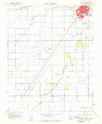
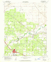
 1960 Atwater1961 Print · USGSAtwater and the outskirts of Merced are seen here at the dawn of the sixties, characterized by a mix of military presence and intensive irrigation. Trace the evolution of Castle Air Force Base or locate local landmarks like the County Honor Farm and McSwain School.4 unique versions available
 - 1960 Map of Gustine, 1961 Print
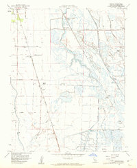
 1960 Gustine1961 Print · USGSThe northern San Joaquin Valley is shown here at the start of the 1960s, shaped by the meeting of the Merced and San Joaquin Rivers. Genealogists and historians can trace the Stevinson Home Ranch, the grounds of Stevinson Sunnyside Cem, and the path of the Old Santa Fe Grade.3 unique versions available
 - 1960 Map of Chowchilla, 1961 Print
 1960 Chowchilla1961 Print · USGSThe agricultural heart of the San Joaquin Valley is shown in the early sixties, centered on the rail hub of Chowchilla. Researchers can trace the legacy of local education and community life through the County Fairgrounds, Fuller Sch, and the Chowchilla Cemetery.2 unique versions available
 - 1960 Map of Ingomar, 1961 Print
 1960 Ingomar1961 Print · USGSMerced County marshlands and ranching tracts are captured here in the early sixties, showing a landscape defined by water management and the Southern Pacific rail line. Genealogists and local historians can locate Ingomar, trace family-named roads like Kniebes Road, and explore dozens of legacy hunting sites including the Gustine Gun Club.2 unique versions available
 - 1960 Map of Chowchilla, 1962 Print
 1960 Chowchilla1962 Print · USGSThe San Joaquin Valley's agricultural heartland is mapped here during a period of steady growth along the Southern Pacific rail line. Genealogists can locate family sites near Chowchilla, Le Grand, and Ashview Sch, or trace historical property lines along SANDY MUSH ROAD.
 - 1961 Map of Turlock, 1962 Print
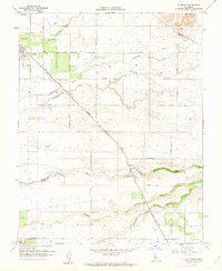
 1961 Turlock1962 Print · USGSIn the early sixties, the agricultural heart of the San Joaquin Valley revolved around the rail-and-canal network surrounding Turlock. Genealogists and local historians can trace family-named roads and schools like Roselawn Sch or locate the old commercial corridors of Delhi and Irwin.3 unique versions available
 - 1961 Map of Stevinson, 1962 Print
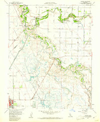
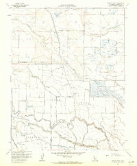
 1961 Stevinson1962 Print · USGSStevinson and the surrounding Merced County wetlands are captured here in the early sixties, showing a landscape defined by the San Joaquin and Merced Rivers. Researchers can trace the layout of the Merquin School, find the old Modesto Gun Club, or locate the Milliken Bridge and Hagaman Park along the riverbanks.3 unique versions available
 - 1961 Map of San Luis Ranch, 1962 Print
 1961 San Luis Ranch1962 Print · USGSMerced County's wetlands and river islands are captured here in the early sixties, a time of extensive water management and private hunting reserves. Researchers can trace the water systems around San Luis Island or locate historic sporting sites like the Standard Gun Club and San Luis Ranch.2 unique versions available
 - 1961 Map of Turner Ranch, 1962 Print
 1961 Turner Ranch1962 Print · USGSMerced County in the early sixties was a landscape defined by industrial water management and the expansive wetlands of the San Joaquin Valley. Genealogists and historians can trace family-named landholdings like Crane Ranch and McNamara Ranch or explore the early footprint of the Merced National Wildlife Refuge.3 unique versions available
 - 1961 Map of Le Grand, 1962 Print
 1961 Le Grand1962 Print · USGSThe agricultural plains of Merced and Madera counties are captured here in the early sixties as irrigation transformed the valley. Genealogists and local historians can trace the Atchison Topeka and Santa Fe line through Le Grand and locate family landmarks like Raynor Ranch.2 unique versions available
 - 1961 Map of Delta Ranch, 1962 Print
 1961 Delta Ranch1962 Print · USGSAgricultural ranching and complex irrigation networks defined the Merced County landscape during the early 1960s. Genealogists and local historians can trace legacy holdings like the Miller and Lux Ranch and the Sportsman Ranch, or locate the Sierra Gun Club near the Duck Ponds.3 unique versions available
 - 1961 Map of Raynor Creek, 1963 Print
 1961 Raynor Creek1963 Print · USGSThe foothills of Madera and Merced counties come into focus in the early sixties as agricultural irrigation reshapes the valley floor. Genealogists and researchers can trace local landmarks like Raynor Ranch Road, Table Mtn, and the Diversion Dam on the Chowchilla River.3 unique versions available
 - 1961 Map of Winton, 1963 Print
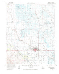
 1961 Winton1963 Print · USGSMerced County agriculture and military operations intersect in the early sixties near the town of Winton. Local researchers can trace the footprint of Castle Air Force Base alongside community landmarks like Hopeton Cem and the Shaffer Bridge over the river.3 unique versions available
 - 1961 Map of Merced, 1963 Print
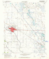
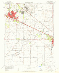
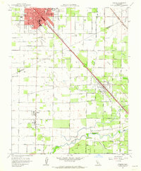
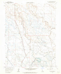
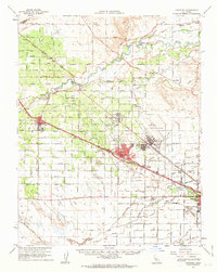
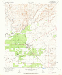
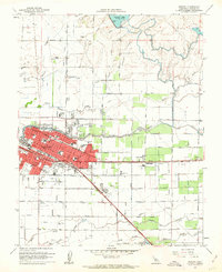 1961 Merced1963 Print · USGSMerced at the start of the 1960s reveals a growing Central Valley hub defined by its busy rail corridors and neighborhood schools. Genealogists can locate family sites near Evergreen Cemetery, Applegate Park, and landmark institutions like Our Lady of Mercy School.3 unique versions available
 - 1961 Map of Le Grand, 1963 Print
 1961 Le Grand1963 Print · USGSMerced and Madera Counties come into focus in the early sixties, showing the vital intersection of the Southern Pacific and Santa Fe rail lines. Genealogists and researchers can locate the Madera Air Force Station, trace the rural Dixieland Sch, and find the exact positions of settlements like Fairmead and Le Grand.
 - 1961 Map of Cressey, 1963 Print
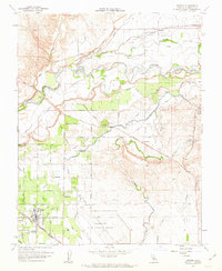
 1961 Cressey1963 Print · USGSThe San Joaquin Valley's agricultural and rail heritage is on full display in the early sixties as irrigation transforms the Merced County landscape. Genealogists and historians can trace the growth of Livingston and Cressey while locating family landmarks like Winton Cem and the McConnell State Park.3 unique versions available
 - 1961 Map of Los Banos, 1963 Print
 1961 Los Banos1963 Print · USGSMerced County in the early 1960s reveals an engineered agricultural landscape of extensive canal systems and railroad-aligned towns. Genealogists and local researchers can trace family landmarks like Odd Fellows Grove, the local Cem, and the busy hub of Los Banos.
 - 1961 Map of Atwater, 1963 Print
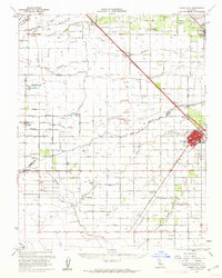
 1961 Atwater1963 Print · USGSThe San Joaquin Valley's agricultural and military landscape comes alive in the early sixties as the jet age meets established rail towns. Local historians can trace the development of Castle Air Force Base and find local landmarks like Hopeton Cem, Shaffer Bridge, and numerous rural schools.2 unique versions available
 - 1961 Map of Planada, 1963 Print
 1961 Planada1963 Print · USGSThe agricultural heart of Merced County is captured here in the early 1960s as industrial farming and irrigation networks expanded. Researchers can trace the rail-side growth of Planada, identify the Calpack facility, and locate family-named routes like Bonner Road.2 unique versions available
Showing maps 1-25 of 54
Top cities of Merced County
- Merced historical maps
- Los Banos historical maps
- Atwater historical maps
- Livingston historical maps
- Delhi historical maps
- Winton historical maps
See more
Frequently asked questions
- What are the different types of historical maps available for Merced County?
- What is the oldest map of Merced County?
- Where can I purchase historical maps of Merced County for my home or office?
- Where can I download high-res historical maps of Merced County?
- Are there historical topographic maps available for Merced County?
- Is there historical aerial imagery available for Merced County?
- Where are historical maps of Merced County sourced from?