1940s Maps of Merced County, California
Explore 41 historic maps of Merced County from the 1940s. These maps offer a rare glimpse into what life looked like during the 1940s — showing old roads, neighborhoods, homes, and landmarks that have changed or disappeared over time.
Whether you're researching your family's past, planning a metal detecting trip, or studying how Merced County's landscape evolved across the 1940s, these high-resolution maps are a powerful tool for exploring the history of this region.
- Focus on a specific era: All maps on this page are from the 1940s, giving you a focused view of this time period.
- See what’s changed: Compare century-old streets, trails, and buildings to today's modern landscape using overlays and satellite layers.
- Research with precision: Use these maps for genealogy, historical research, land use analysis, or educational projects.
- View, download, or print: Maps are fully viewable online in high resolution, and can be downloaded or printed for your own records.
Start exploring Merced County's history through authentic maps from the 1940s. This is your window into the past.
Merced County, CA maps
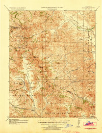
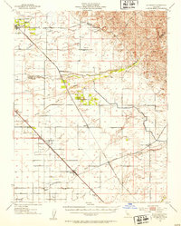
(41)- 1940 Map of Pacheco Pass
 1940 Pacheco Pass1940 Print · USGSPacheco Pass and the surrounding Merced County foothills are captured here in the years leading up to the war. Genealogists can locate family holdings like Howard Ranch and Fifield Ranch, or trace rural education at Romero School.
 - 1940 Map of Quien Sabe
 1940 Quien Sabe1940 Print · USGSThe San Benito and Merced county lines meet in this 1940 survey of the Diablo Range highlands and interior ranch lands. Researchers can trace the early property lines of the Real de las Aguilas, find the Stayton Mine, and locate the old Quien Sabe School.2 unique versions available
 - 1941 Map of Orestimba
 1941 Orestimba1941 Print · USGSThe San Joaquin Valley and Diablo Range foothills meet here in the early 1940s, showing a landscape defined by industrial irrigation and rail. Trace the Southern Pacific line through Patterson and Newman, or locate rural landmarks like the Canal School and Stimba Pumping Station.
 - 1942 Map of Irwin
 1942 Irwin1942 Print · USGSThe San Joaquin and Merced rivers dominate this 1940s landscape where early irrigation networks met established rail lines. Genealogists can trace rural school districts like Tegner Sch and Helmar Sch or locate old river crossings at Hills Ferry and Fremont Ford.
 - 1942 Map of Athlone
 1942 Athlone1942 Print · USGSThe Merced and Madera county line area is shown here in the early 1940s as agricultural irrigation and rail transport defined the region. Genealogists can locate family-named landmarks like Bliss Ranch and several rural schoolhouses including Alamo Sch and Pioneer Sch.
 - 1943 Map of Ortigalita Peak
 1943 Ortigalita Peak1943 Print · USGSThe Merced and San Benito county line was a landscape of remote cattle ranches and early Central Valley irrigation works during the 1940s. Genealogists and local historians can trace family-named sites like Langan Ranch, Hamburg Ranch Sch, and the Oil Pumping Sta.2 unique versions available
 - 1944 Map of Merced Falls
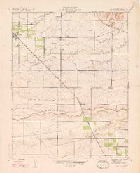
 1944 Merced Falls1944 Print · USGSThe California foothills in the early forties reveal a landscape of active river dredging and massive reservoirs. Trace the historic Coulterville Road through the mines at Solambo Mine Ridge or locate the dredging Tailings near Snelling.2 unique versions available
 - 1944 Map of Panoche Valley
 1944 Panoche Valley1944 Print · USGSPanoche Valley and the high ridges of the Diablo Range are captured here during the 1940s, showcasing the region's rural ranching and mining history. Genealogists and historians can locate old landmarks like Panoche Sch, Llanada, and the Le Grant Mine nestled among the hills.2 unique versions available
 - 1946 Map of Sandy Mush, 1947 Print
 1946 Sandy Mush1947 Print · USGSMerced County agriculture is in full bloom in the mid-1940s, showing a landscape defined by windmills and winding sloughs. Genealogists and researchers can trace the area's rural development through the Lone Tree Sch, Potter Field, and the historic Sandy Mush and Athlone Road.
 - 1946 Map of Le Grand, 1953 Print
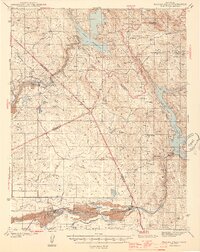
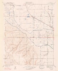
 1946 Le Grand1953 Print · USGSThe San Joaquin Valley agricultural heartland comes into focus during the mid-forties, showing the vital rail corridors and watercourses that shaped the region. Genealogists and local researchers can trace early settlements and rural school sites like Dixieland School, Fairmead, and the northern hub of Le Grand.2 unique versions available
 - 1946 Map of Merced, 1954 Print
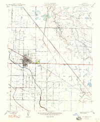
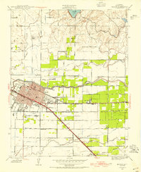 1946 Merced1954 Print · USGSMid-century Merced and its surrounding farm colonies are captured here just after the war, showing the area's transition into a regional agricultural powerhouse. Genealogists can locate family-named landmarks and rural education sites like Merced Colony School and the settlement of Creegan.
 - 1946 Map of Santa Rita Park, 1954 Print
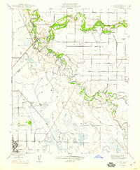
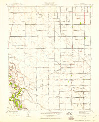
 1946 Santa Rita Park1954 Print · USGSThe San Joaquin Valley's intricate network of sloughs and early irrigation canals is captured here as the ranching economy thrived after the war. Family historians can trace dozens of named estates and local landmarks like Santa Rita Park, Lone Tree Sch, and Wolfsen Mill.
 - 1946 Map of Le Grand, 1961 Print
 1946 Le Grand1961 Print · USGSLe Grand and the surrounding Central Valley ranch lands are captured here just after the war as the region's agricultural footprint matured. Researchers can trace the path of the Atchison Topeka and Santa Fe through Le Grand and Marguerite, or locate early industrial sites like the Gravel Pit near Mariposa Creek.
 - 1947 Map of Gustine
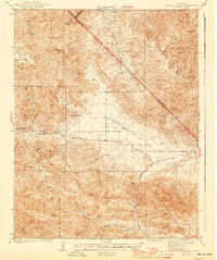
 1947 Gustine1947 Print · USGSThe northern San Joaquin Valley comes into focus just after the war as the agricultural and irrigation networks expand around the So Pacific tracks. Genealogists can trace family footprints at Hills Ferry, Bella Vista Park, and the Stevinson Home-Ranch.
 - 1947 Map of San Luis Ranch
 1947 San Luis Ranch1947 Print · USGSMerced County’s wetland and ranching heartland is captured here in the late 1940s as a complex network of waterways. Trace the legacy of early river crossings and water rights at the Old Dickenson Ferry, San Luis Ranch, and the Santa Fe Canal.
 - 1947 Map of Los Banos
 1947 Los Banos1947 Print · USGSMid-century Merced County reveals an intensive irrigation landscape anchored by the growing town of Los Banos. Genealogists and historians can trace the rail-side growth of Abatto and the complex water networks of the Main Canal and Arroyo Canal.
 - 1947 Map of Volta
 1947 Volta1947 Print · USGSMerced County agriculture and rail transit are captured here in the years following the war. Genealogists and local historians can trace the irrigation network of the Main Canal and locate early sites like Volta, Trent, and Washboard Road.3 unique versions available
 - 1947 Map of Le Grand
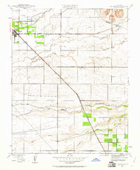
 1947 Le Grand1947 Print · USGSThe Central Valley agricultural landscape of Merced and Madera counties comes into focus just after the war. Researchers can trace the Sharon Atchison Topeka and Santa Fe line through Le Grand and Marguerite, past Ash Slough and dozens of rural windmills.
 - 1947 Map of Ingomar
 1947 Ingomar1947 Print · USGSThe northern San Joaquin Valley in the late 1940s is shown here as a landscape of railroads and irrigation. Genealogists and researchers can trace the agricultural heart of Merced County through the Southern Pacific line, the Ingomar Ranch, and the Linora Pumping Station.
 - 1947 Map of Raynor Creek
 1947 Raynor Creek1947 Print · USGSMadera and Merced counties meet along the Chowchilla River during the late 1940s, a period of ranching and rural development. Genealogists can trace early routes like Buchanan Road and family-named landmarks such as Raynor Creek.2 unique versions available
 - 1947 Map of Plainsburg
 1947 Plainsburg1947 Print · USGSIn the San Joaquin Valley after the war, this area shows a landscape defined by irrigation and heavy rail. Trace the old stops at Athlone and Minturn, locate the Savana Sch, or find the numerous windmills dotting the plains near Plainsburg.2 unique versions available
 - 1947 Map of San Jose, 1948 Print
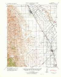
 1947 San Jose1948 Print · USGSNorthern California's heartland is captured here just after the war, showing the rapid growth of the Santa Clara and Central Valleys. Researchers can trace the legacy of rail and water at Castle Air Force Base, Stockton, and the Hetch Hetchy Aqueduct.
 - 1948 Map of Santa Cruz
 1948 Santa Cruz1948 Print · USGSThe Central Coast and San Joaquin Valley meet in this mid-century look at the region's agricultural and military geography. Genealogists and historians can trace the paths of El Camino Real, locate family farms near Hollister, or study the footprint of the Fort Ord Military Reservation.2 unique versions available
 - 1948 Map of Sandy Mush
 1948 Sandy Mush1948 Print · USGSSandy Mush and the surrounding Merced County ranchlands are captured here in the late 1940s, showing a landscape defined by water management. Genealogists and historians can trace family-named roads like El Nido Road and find the site of the Lone Tree Sch.
 - 1948 Map of Mitchell School
 1948 Mitchell School1948 Print · USGSThe Central Valley borderlands of Stanislaus and Merced counties show a landscape defined by irrigation and early rural education. Trace the development of local farming communities through sites like Hatch, the Southern Pacific Railroad, and a remarkable concentration of country schools including Mitchell Sch and Hilmar Sch.2 unique versions available
Showing maps 1-25 of 41
Top cities of Merced County
- Merced historical maps
- Los Banos historical maps
- Atwater historical maps
- Livingston historical maps
- Delhi historical maps
- Winton historical maps
See more
Frequently asked questions
- What are the different types of historical maps available for Merced County?
- What is the oldest map of Merced County?
- Where can I purchase historical maps of Merced County for my home or office?
- Where can I download high-res historical maps of Merced County?
- Are there historical topographic maps available for Merced County?
- Is there historical aerial imagery available for Merced County?
- Where are historical maps of Merced County sourced from?