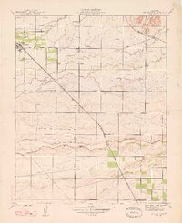
1947 Map of Le Grand
USGS Topo · Published 1947About this map
Le Grand and the surrounding San Joaquin Valley landscape are defined here by a network of agricultural water management and early transportation corridors during the mid-1940s. The town acts as a central hub where the Sharon Atchison Topeka and Santa Fe railroad intersects with local arteries like the Plainsburg and Buchanan Hollow Road. This survey captures a specific hydraulic environment where the Chowchilla River and intermittent waterways like Ash Slough and Berenda Slough are punctuated by numerous Windmills across the plains.
Find a feature on this map
16 named features on this map. Tap any name to fly to it.
Don’t see what you’re looking for? This feature index may not catch every label — zoom into the map to look around manually.
Map Details
Editions of this 1947 Le Grand Map
This is the sole edition of this map. No revisions or reprints were ever made.
Other maps of this area

1915 · Owens Creek
USGS Topo · 1:31,680

1916 · Berenda
USGS Topo · 1:31,680

1918 · Owens Creek
USGS Topo · 1:31,680

1918 · Chowchilla
USGS Topo · 1:31,680

1918 · Berenda
USGS Topo · 1:31,680

1918 · Planada
USGS Topo · 1:31,680

1918 · La Grand
USGS Topo · 1:31,680

1919 · Indian Gulch
USGS Topo · 1:48,000

1919 · Plainsberg
USGS Topo · 1:31,680

1919 · Raynor Creek
USGS Topo · 1:31,680