Old Maps of Santa Rita Park, California for Metal Detecting
Plan your next treasure hunt with 16 historic maps of Santa Rita Park. Find old homesites, ghost towns, trails, and gathering spots that may be lost to time — perfect for identifying promising metal detecting locations.
- Locate forgotten sites: Uncover places like long-lost settlements, abandoned rail lines, or gathering spots.
- Plan better hunts: Use map overlays combined with LiDAR or satellite views to narrow in on historically rich areas.
- Made for detectorists: Thousands of hobbyists use these maps to discover relics, coins, and hidden history.
Use these historic maps to boost your research and find new opportunities beneath the surface of Santa Rita Park.
Santa Rita Park, CA maps
(16)- 1916 Map of Santa Rita Bridge, 1948 Print
 1916 Santa Rita Bridge1948 Print · USGSThe San Joaquin River valley was a landscape of ambitious ranching and irrigation in the mid-1940s. Genealogists and local historians can trace legacy holdings like Wolfsen Mill, Belmont Ranch, and Temple Ranch across this three-county border region.2 unique versions available
 - 1920 Map of Santa Rita Bridge
 1920 Santa Rita Bridge1920 Print · USGSThe central San Joaquin Valley appears here as an intricate network of waterways and early ranching outposts just after the turn of the century. Researchers can trace the legacy of large land holdings like Santa Rita Ranch and find specific sites like the Temple Gun Club or Lucerne Farm.
 - 1922 Map of Santa Rita Bridge
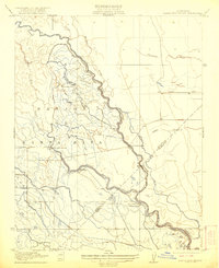 1922 Santa Rita Bridge1922 Print · USGSThe braided channels of the San Joaquin Valley are captured here in the early twentieth century, showing a landscape of sprawling ranches and water rights. Genealogists and historians can trace old property lines and river crossings like Santa Rita Bridge, Santa Rita Ranch, and the Temple Gun Club.2 unique versions available
 - 1946 Map of Santa Rita Park, 1954 Print
 1946 Santa Rita Park1954 Print · USGSThe San Joaquin Valley's intricate network of sloughs and early irrigation canals is captured here as the ranching economy thrived after the war. Family historians can trace dozens of named estates and local landmarks like Santa Rita Park, Lone Tree Sch, and Wolfsen Mill.
 - 1947 Map of San Jose, 1948 Print
 1947 San Jose1948 Print · USGSNorthern California's heartland is captured here just after the war, showing the rapid growth of the Santa Clara and Central Valleys. Researchers can trace the legacy of rail and water at Castle Air Force Base, Stockton, and the Hetch Hetchy Aqueduct.
 - 1948 Map of Santa Rita Bridge
 1948 Santa Rita Bridge1948 Print · USGSThe San Joaquin Valley's water-driven ranching economy is captured here in the late 1940s, highlighting the convergence of three major rivers. Researchers can trace the layout of historic family estates and agricultural hubs like Santa Rita Ranch, Wolfsen Mill, and Colony Farm.
 - 1956 Map of San Jose
 1956 San Jose1956 Print · USGSCentral California in the mid-fifties reveals the transition from sprawling orchards to growing urban hubs like San Jose and Stockton. Genealogists and historians can trace the rail-era landscape of the Mother Lode through Chinese Camp and Tuttletown, or follow the water through the Joaquin River and Calaveras Reservoir.
 - 1962 Map of San Jose
 1962 San Jose1962 Print · USGSCentral California in the early sixties showcases the expansion of the San Joaquin and Santa Clara valleys. Researchers can trace the rail-to-road transition along the Southern Pacific RR or locate landmarks like Castle USAF Base and Loma Prieta.4 unique versions available
 - 1962 Map of Santa Rita Park, 1963 Print
 1962 Santa Rita Park1963 Print · USGSMerced County ranchlands and the Central Valley's complex water network are documented here in the early sixties. Genealogists and local historians can trace legacy holdings like the Miller and Lux Ranch or locate the Flynn Duck Club and Santa Rita Park.
 - 1962 Map of Santa Rita Bridge, 1963 Print
 1962 Santa Rita Bridge1963 Print · USGSThe San Joaquin Valley at the start of the 1960s reveals an intricate landscape of water control and ranching where Merced, Madera, and Fresno counties meet. Genealogists and historians can trace the foundations of local agriculture through family-named sites like Lucerne Ranch, Santa Rita Park, and Colony Farm.2 unique versions available
 - 1966 Map of San Jose
 1966 San Jose1966 Print · USGSCentral California in the mid-1960s reveals a landscape of massive irrigation projects and expanding Cold War military footprints. Researchers can trace the rail-and-river network of the San Joaquin Valley or locate specialized sites like Castle Air Force Base and the Sharp General Depot (Military).
 - 1983 Map of Merced
 1983 Merced1983 Print · USGSThe San Joaquin Valley at the start of the eighties is captured here in its full agricultural and military height. Trace the legacy of Castle Air Force Base, old mines like Pocahontas Mine, and the vast Kesterson National Wildlife Refuge.
 - 2012 Map of Santa Rita Bridge, 2012 Print
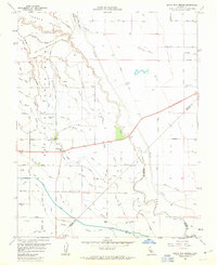
 2012 Santa Rita Bridge2012 Print · USGSCovers Santa Rita Park, including Fresno County, Merced County, and other nearby areas
 - 2015 Map of Santa Rita Bridge, 2015 Print
 2015 Santa Rita Bridge2015 Print · USGSCovers Santa Rita Park, including Fresno County, Merced County, and other nearby areas
 - 2018 Map of Santa Rita Bridge, 2018 Print
 2018 Santa Rita Bridge2018 Print · USGSCovers Santa Rita Park, including Fresno County, Merced County, and other nearby areas
 - 2021 Map of Santa Rita Bridge, 2021 Print
 2021 Santa Rita Bridge2021 Print · USGSThe Central Valley agricultural heartland comes into focus during this modern era of industrial-scale irrigation. Genealogists and local historians can trace family land plots between the San Joaquin River, Santa Rita Park, and the Eastside Bypass.
End of results
Showing maps 1-16 of 16
Top cities near Santa Rita Park
- Merced historical maps
- Los Banos historical maps
- Firebaugh historical maps
- Dos Palos historical maps
- South Dos Palos historical maps
Frequently asked questions
- What are the different types of historical maps available for Santa Rita Park?
- What is the oldest map of Santa Rita Park?
- Where can I purchase historical maps of Santa Rita Park for my home or office?
- Where can I download high-res historical maps of Santa Rita Park?
- Are there historical topographic maps available for Santa Rita Park?
- Is there historical aerial imagery available for Santa Rita Park?
- Where are historical maps of Santa Rita Park sourced from?