1940s Maps of Mono County, California
Explore 5 historic maps of Mono County from the 1940s. These maps offer a rare glimpse into what life looked like during the 1940s — showing old roads, neighborhoods, homes, and landmarks that have changed or disappeared over time.
Whether you're researching your family's past, planning a metal detecting trip, or studying how Mono County's landscape evolved across the 1940s, these high-resolution maps are a powerful tool for exploring the history of this region.
- Focus on a specific era: All maps on this page are from the 1940s, giving you a focused view of this time period.
- See what’s changed: Compare century-old streets, trails, and buildings to today's modern landscape using overlays and satellite layers.
- Research with precision: Use these maps for genealogy, historical research, land use analysis, or educational projects.
- View, download, or print: Maps are fully viewable online in high resolution, and can be downloaded or printed for your own records.
Start exploring Mono County's history through authentic maps from the 1940s. This is your window into the past.
Mono County, CA maps
(5)- 1947 Map of Mariposa, 1948 Print
 1947 Mariposa1948 Print · USGSThe High Sierra and Owens Valley transition is captured here in the late 1940s, just as the region’s hydroelectric and tourism infrastructure was maturing. Genealogists and historians can trace old ranger stations, the Casa Diablo Mine, and rail stops along the Southern Pacific like Benton Station and Zurich.2 unique versions available
 - 1948 Map of Walker Lake
 1948 Walker Lake1948 Print · USGSThe high desert of Nevada and the eastern Sierra Nevada are captured just after the war as mining and ranching shaped the local economy. Genealogists can trace family connections to centers like Hawthorne and Mina or locate the historic Rockland Mines and Aurora.2 unique versions available
 - 1948 Map of Mariposa, 1951 Print
 1948 Mariposa1951 Print · USGSThe High Sierra and Mariposa foothills are shown here in the late 1940s as the post-war tourism and water infrastructure expanded. Genealogists and historians can locate vanished waypoints like Mormon Bar, the Glacier Point Hotel, and the granite quarries of Knowles.
 - 1949 Map of Mt. Tom, 1955 Print
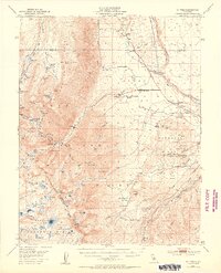 1949 Mt. Tom1955 Print · USGSIn the Sierra Nevada during the late 1940s, the tungsten mining boom transformed the landscape around Round Valley. Researchers can trace industrial sites like the Adamson Mine, locate the Round Valley School, and explore the canyon routes leading to Scheelite.6 unique versions available
 - 1949 Map of Bishop, 1956 Print
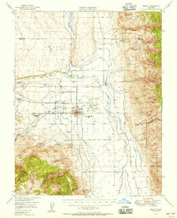 1949 Bishop1956 Print · USGSThe Owens Valley was a center of mining and water engineering at mid-century, dominated by the growth of Bishop. Researchers can trace the legacy of tribal lands at the Paiute Shoshone Indian Reservation or locate extraction sites like the Rossi Tungsten Mine and Southern Belle Mine.4 unique versions available
End of results
Showing maps 1-5 of 5
Top cities of Mono County
- Mammoth Lakes historical maps
- June Lake historical maps
- Crowley Lake historical maps
- Walker historical maps
- Chalfant Valley historical maps
- Coleville historical maps
See more
Frequently asked questions
- What are the different types of historical maps available for Mono County?
- What is the oldest map of Mono County?
- Where can I purchase historical maps of Mono County for my home or office?
- Where can I download high-res historical maps of Mono County?
- Are there historical topographic maps available for Mono County?
- Is there historical aerial imagery available for Mono County?
- Where are historical maps of Mono County sourced from?