1950s Maps of Mono County, California
Explore 32 historic maps of Mono County from the 1950s. These maps offer a rare glimpse into what life looked like during the 1950s — showing old roads, neighborhoods, homes, and landmarks that have changed or disappeared over time.
Whether you're researching your family's past, planning a metal detecting trip, or studying how Mono County's landscape evolved across the 1950s, these high-resolution maps are a powerful tool for exploring the history of this region.
- Focus on a specific era: All maps on this page are from the 1950s, giving you a focused view of this time period.
- See what’s changed: Compare century-old streets, trails, and buildings to today's modern landscape using overlays and satellite layers.
- Research with precision: Use these maps for genealogy, historical research, land use analysis, or educational projects.
- View, download, or print: Maps are fully viewable online in high resolution, and can be downloaded or printed for your own records.
Start exploring Mono County's history through authentic maps from the 1950s. This is your window into the past.
Mono County, CA maps
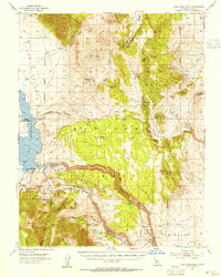
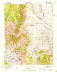
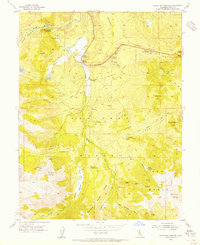
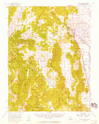
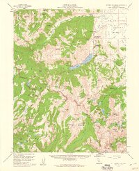
(32)- 1951 Map of Mt. Tom
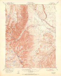 1951 Mt. Tom1951 Print · USGSInyo County mining reached its peak in the early fifties as tungsten and vanadium extraction transformed the eastern Sierra slopes. Researchers can trace the era's industrial footprint through the Pine Creek Mine, Tungsten Hills, and the company town at Rovana.2 unique versions available
 - 1951 Map of Bishop
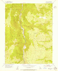
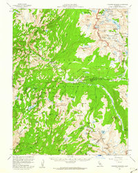
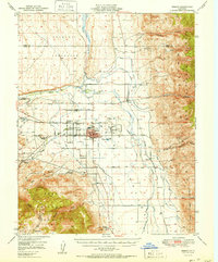 1951 Bishop1951 Print · USGSOwens Valley thrives as an agricultural and mining center in the early fifties, mapped just before local shifts in water and rail. Trace the Southern Pacific line past Laws or locate the Southern Belle Mine and Keough Hot Springs.
 - 1951 Map of Blanco Mountain, 1953 Print
 1951 Blanco Mountain1953 Print · USGSThe Inyo Mountains and Deep Spring Valley appear in the early fifties as a landscape of high-altitude research and mining. Trace old workings like Wilkerson Mine and remote outposts such as Roberts Ranch or the Naval Research Station.5 unique versions available
 - 1953 Map of Mt. Morrison, 1955 Print
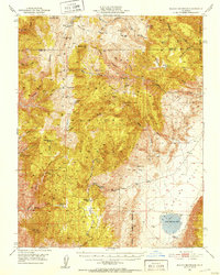
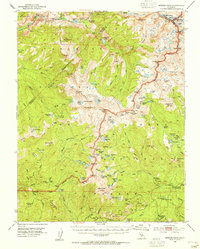
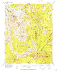
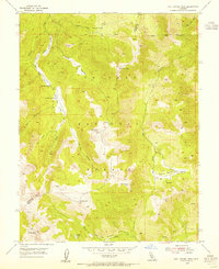
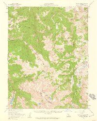
 1953 Mt. Morrison1955 Print · USGSThe Eastern Sierra Nevada and Owens River valley appear here in the early fifties, a time of both ranching and high-altitude recreation. Genealogists and historians can trace Arcularius Ranch, the site at Old Mammoth, and the Scheelore Mine among the mountain peaks.7 unique versions available
 - 1953 Map of Casa Diablo Mtn, 1955 Print
 1953 Casa Diablo Mtn1955 Print · USGSThe High Sierra and Benton Range meet in the early 1950s, showing a landscape defined by Owens River water and hard-rock mining. Trace the historic mining district through the Casa Diablo Mine, Kings Mill, and the community at Toms Place.4 unique versions available
 - 1953 Map of Merced Peak, 1955 Print
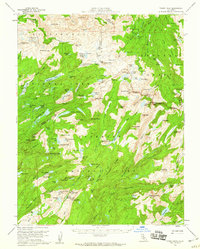
 1953 Merced Peak1955 Print · USGSThe High Sierra wilderness of the early fifties is mapped here in detail, spanning the boundary of Yosemite and the national forests. Researchers can locate remote outposts and industry like the Strawberry Tungsten Mine, Knoblock Cabin, and the Merced Lake Ranger Sta.7 unique versions available
 - 1953 Map of Mt Abbot, 1955 Print
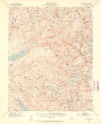 1953 Mt Abbot1955 Print · USGSThe central Sierra Nevada is captured here during a decade of infrastructure expansion and wilderness trekking. Researchers can trace the John Muir Trail, locate the Pick and Shovel Mine, or identify seasonal landmarks like Kip Camp.7 unique versions available
 - 1953 Map of Mono Craters, 1955 Print
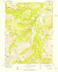
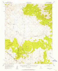
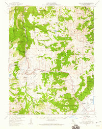
 1953 Mono Craters1955 Print · USGSThe eastern Sierra Nevada meets the high basin in the early 1950s, showing the early development of recreational and industrial corridors. Genealogists and historians can trace high-altitude infrastructure like the Log Cabin Mine, the State Fish Hatchery, and the Mono Lake Aqueduct.6 unique versions available
 - 1953 Map of Devils Postpile, 1955 Print
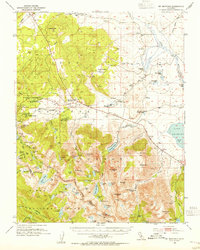
 1953 Devils Postpile1955 Print · USGSThe high Sierra back-country is captured in the early 1950s, a period where mining history and emerging recreation met at the crest. You can trace the rugged network of pack trails and early ranger stations including Reds Meadow RS, the Minaret Mine, and the iconic Devils Postpile.6 unique versions available
 - 1954 Map of Chris Flat, 1955 Print
 1954 Chris Flat1955 Print · USGSMono County's high Sierra landscape is captured here in the mid-1950s, centered on the rugged corridor of the West Walker River. Trace early frontier footprints at Tollhouse Flat, locate the Deep Creek Mine, or find high-country grazing spots like Grouse Meadows.5 unique versions available
 - 1954 Map of Mt. Tom, 1955 Print
 1954 Mt. Tom1955 Print · USGSThe eastern Sierra Nevada is captured here during the peak of its mid-century tungsten mining boom. Genealogists and historians can trace the industrial footprints of Scheelite and Rovana, or locate remote landmarks like Paradise Camp and the Round Valley School.2 unique versions available
 - 1954 Map of Pickel Meadow, 1955 Print
 1954 Pickel Meadow1955 Print · USGSThe high Sierra landscape near the Alpine and Mono County line is documented here in the mid-fifties. Researchers can trace the layout of the Marine Corps Cold Weather Camp and locate the historic Leavitt Sta (Site) near Leavitt Meadow.4 unique versions available
 - 1954 Map of Fales Hot Springs, 1955 Print
 1954 Fales Hot Springs1955 Print · USGSHigh Sierra mountain life and water management are captured in the mid-1950s near the West Walker River in Mono County. Genealogists and researchers can trace seasonal mountain camps and stations like Hardy Station, Rickey Cabin, and the Little Walker Cowcamp.4 unique versions available
 - 1954 Map of Lost Cannon Peak, 1955 Print
 1954 Lost Cannon Peak1955 Print · USGSHigh Sierra grazing grounds and peaks define this mid-1950s survey of the Alpine and Mono County border. Researchers can trace historic seasonal outposts like Connells Cow Camp or explore the rugged drainage of Lost Cannon Creek.5 unique versions available
 - 1954 Map of Goldfield, 1967 Print
 1954 Goldfield1967 Print · USGSThe Nevada desert during the early Cold War era shows the convergence of traditional mining districts and military expansion. Genealogists and historians can trace the Tonopah and Tidewater Railroad route and locate remote sites like Gold Point and Scottys Castle.3 unique versions available
 - 1955 Map of Goldfield
 1955 Goldfield1955 Print · USGSThe Nevada desert in the mid-fifties reveals a landscape of mining camps and military expansion. You can trace legacy sites from the Klondike Mine to Gold Point, and locate remote outposts like Bonnie Claire and Staininger Ranch at the edge of Death Valley.
 - 1956 Map of Aurora, 1957 Print
 1956 Aurora1957 Print · USGSThe Nevada-California borderlands are documented here in the mid-fifties, capturing the remnant mining hubs and high desert ranches of the era. Genealogists and historians can trace the Aurora townsite, the Cresco Mine, and local landmarks like Lucky Boy Pass.3 unique versions available
 - 1956 Map of Desert Creek Peak, 1958 Print
 1956 Desert Creek Peak1958 Print · USGSThe Nevada-California borderlands were a hub of high-desert mining and ranching during the mid-fifties. Researchers can trace the original Von Schmidt Line (1872) and locate historic sites like Rickey Mine, Sulfur (Site), and Hoye Bridge.3 unique versions available
 - 1956 Map of Topaz Lake, 1958 Print
 1956 Topaz Lake1958 Print · USGSThe Sierra Nevada borderlands come alive in the mid-1950s, showing a landscape defined by high-country mining and early mountain transit. Researchers can trace historic state boundaries along the VON SCHMIDT LINE or locate old operations at the Leviathan Mine and Topaz PO.4 unique versions available
 - 1956 Map of Sonora Pass, 1959 Print
 1956 Sonora Pass1959 Print · USGSThe High Sierra crest near the Mono and Alpine county lines is captured here in the mid-1950s during a period of seasonal mountain use. Researchers can trace the historic Leavitt Sta (Site), locate the Marine Corps Cold Weather Camp, and explore the drainages of the Pickel River and East Fork Carson River.5 unique versions available
 - 1956 Map of Fales Hot Springs, 1960 Print
 1956 Fales Hot Springs1960 Print · USGSThe high Sierra backcountry and Mono County mining districts are captured here in the mid-1950s. Genealogists and historians can trace the foundations of the regional economy through sites like Sonora Junction Hardy Station, Burcham, and the Tiger Mines.5 unique versions available
 - 1956 Map of Tower Peak, 1960 Print
 1956 Tower Peak1960 Print · USGSThe High Sierra backcountry near the Tuolumne and Mono County line is documented here in the mid-fifties. Researchers can trace the high-altitude trails to isolated landmarks like Piute Cabin, Sachse Monument, and the high-elevation workings of the Montezuma Mine.4 unique versions available
 - 1956 Map of Matterhorn Peak, 1960 Print
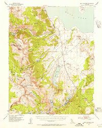
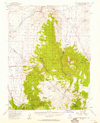
 1956 Matterhorn Peak1960 Print · USGSThe high Sierra wilderness of Mono County in the late 1950s reveals a landscape of remote cattle ranches and high-altitude mining claims. Researchers can trace historic outposts like the McMillan Cabin, early tourism at Mono Village, and the remote May Lundy Mine.4 unique versions available
 - 1956 Map of Tuolumne Meadows, 1960 Print
 1956 Tuolumne Meadows1960 Print · USGSTuolumne County in the mid-fifties features a high-country landscape of granite domes and remote camps before the era of modern development. Researchers can trace historic backcountry sites like Parsons Memorial Lodge and the Fahntail Mine or locate early wilderness outposts at May Lake High Sierra Camp.5 unique versions available
 - 1957 Map of Walker Lake
 1957 Walker Lake1957 Print · USGSThe Nevada-California borderlands in the mid-1950s show a rugged network of mining camps and river-valley towns centered around Walker Lake. Researchers can trace the Southern Pacific rail line and locate historical sites like Bodie, Sodaville, and the Leviathan Sulphur Mine.4 unique versions available
Showing maps 1-25 of 32
Top cities of Mono County
- Mammoth Lakes historical maps
- June Lake historical maps
- Crowley Lake historical maps
- Walker historical maps
- Chalfant Valley historical maps
- Coleville historical maps
See more
Frequently asked questions
- What are the different types of historical maps available for Mono County?
- What is the oldest map of Mono County?
- Where can I purchase historical maps of Mono County for my home or office?
- Where can I download high-res historical maps of Mono County?
- Are there historical topographic maps available for Mono County?
- Is there historical aerial imagery available for Mono County?
- Where are historical maps of Mono County sourced from?