1950s Maps of Mammoth Lakes, California
Explore 3 historic maps of Mammoth Lakes from the 1950s. These maps offer a rare glimpse into what life looked like during the 1950s — showing old roads, neighborhoods, homes, and landmarks that have changed or disappeared over time.
Whether you're researching your family's past, planning a metal detecting trip, or studying how Mammoth Lakes's landscape evolved across the 1950s, these high-resolution maps are a powerful tool for exploring the history of this region.
- Focus on a specific era: All maps on this page are from the 1950s, giving you a focused view of this time period.
- See what’s changed: Compare century-old streets, trails, and buildings to today's modern landscape using overlays and satellite layers.
- Research with precision: Use these maps for genealogy, historical research, land use analysis, or educational projects.
- View, download, or print: Maps are fully viewable online in high resolution, and can be downloaded or printed for your own records.
Start exploring Mammoth Lakes's history through authentic maps from the 1950s. This is your window into the past.
Mammoth Lakes, CA maps
(3)- 1953 Map of Mt. Morrison, 1955 Print
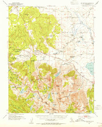 1953 Mt. Morrison1955 Print · USGSThe Eastern Sierra Nevada and Owens River valley appear here in the early fifties, a time of both ranching and high-altitude recreation. Genealogists and historians can trace Arcularius Ranch, the site at Old Mammoth, and the Scheelore Mine among the mountain peaks.7 unique versions available
 - 1953 Map of Devils Postpile, 1955 Print
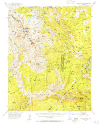 1953 Devils Postpile1955 Print · USGSThe high Sierra back-country is captured in the early 1950s, a period where mining history and emerging recreation met at the crest. You can trace the rugged network of pack trails and early ranger stations including Reds Meadow RS, the Minaret Mine, and the iconic Devils Postpile.6 unique versions available
 - 1957 Map of Mariposa, 1966 Print
 1957 Mariposa1966 Print · USGSThe High Sierra and Owens Valley appear in the mid-fifties, showing the intersection of conservation, hydroelectric power, and mountain industry. Genealogists and researchers can trace local landmarks like Yosemite Cemetery, the remote Kinsley Station, and the Pine Creek Mine.4 unique versions available
End of results
Showing maps 1-3 of 3
Top cities near Mammoth Lakes
Top neighborhoods of Mammoth Lakes
Frequently asked questions
- What are the different types of historical maps available for Mammoth Lakes?
- What is the oldest map of Mammoth Lakes?
- Where can I purchase historical maps of Mammoth Lakes for my home or office?
- Where can I download high-res historical maps of Mammoth Lakes?
- Are there historical topographic maps available for Mammoth Lakes?
- Is there historical aerial imagery available for Mammoth Lakes?
- Where are historical maps of Mammoth Lakes sourced from?