1960s Maps of Irvine, California
Explore 9 historic maps of Irvine from the 1960s. These maps offer a rare glimpse into what life looked like during the 1960s — showing old roads, neighborhoods, homes, and landmarks that have changed or disappeared over time.
Whether you're researching your family's past, planning a metal detecting trip, or studying how Irvine's landscape evolved across the 1960s, these high-resolution maps are a powerful tool for exploring the history of this region.
- Focus on a specific era: All maps on this page are from the 1960s, giving you a focused view of this time period.
- See what’s changed: Compare century-old streets, trails, and buildings to today's modern landscape using overlays and satellite layers.
- Research with precision: Use these maps for genealogy, historical research, land use analysis, or educational projects.
- View, download, or print: Maps are fully viewable online in high resolution, and can be downloaded or printed for your own records.
Start exploring Irvine's history through authentic maps from the 1960s. This is your window into the past.
Irvine, CA maps
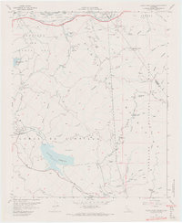
(9)- 1960 Map of Santa Ana
 1960 Santa Ana1960 Print · USGSSouthern California's coastal plains and inland deserts meet in this mid-century survey of the burgeoning Orange and Riverside county corridors. Researchers can trace the layout of early freeway systems, find tribal lands like the Soboba Indian Reservation, and locate military landmarks such as March Field.2 unique versions available
 - 1962 Map of Tustin, 1975 Print
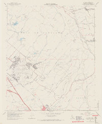
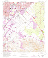 1962 Tustin1975 Print · USGSOrange County's agricultural heartland undergoes rapid transformation into a modern suburban and institutional hub during the early sixties. Researchers can trace the early footprints of the University of California (Irvine), the Marine Corps Air Facility, and legacy ranch sites like East Irvine.
 - 1964 Map of Orange, 1966 Print
 1964 Orange1966 Print · USGSMid-century Orange County is caught in a moment of rapid suburban transformation as citrus groves give way to residential grids and new freeways. Genealogists and local researchers can trace the development of established neighborhoods near Chapman College, locate family plots at St Johns Cem, or explore the foothills around Cowan Heights and Irvine Park.5 unique versions available
 - 1965 Map of Santa Ana
 1965 Santa Ana1965 Print · USGSSouthern California is captured in a decade of rapid growth, showing the coastal expansion from Santa Ana down to Oceanside. Genealogists and historians can trace the mid-century development of places like Garden Grove or the rural reaches of Escondido and the Palomar Observatory.
 - 1965 Map of Laguna Beach, 1967 Print
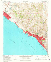 1965 Laguna Beach1967 Print · USGSCoastal Orange County is captured here during the mid-sixties growth surge, showing the transition from open hills to modern shorefront communities. Researchers can trace local development through landmarks like Crystal Cove, Top of the World, and St Catherine of Siena Sch.4 unique versions available
 - 1965 Map of Tustin, 1967 Print
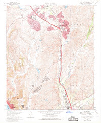
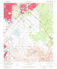 1965 Tustin1967 Print · USGSMid-century Orange County is caught in a moment of suburban transformation as the ranch lands transition to university and military use. Genealogists can trace family-named schools and vanished sidings like Irvine (Valencia Siding) and the Twenty Ranch Gun Club.2 unique versions available
 - 1967 Map of Black Star Canyon, 1968 Print
 1967 Black Star Canyon1968 Print · USGSThe Santa Ana Mountains in the late sixties reveal a landscape defined by mining operations and new infrastructure. Researchers can trace resource extraction at the Black Star Coal Mine and locate landmarks like Beeks Place or the Rocket Fuel Test Site.7 unique versions available
 - 1968 Map of San Juan Capistrano, 1969 Print
 1968 San Juan Capistrano1969 Print · USGSCoastal Orange County in the late sixties shows the emergence of iconic master-planned communities and the infrastructure of the postwar boom. Genealogists and local historians can trace early neighborhood layouts in Laguna Hills and Laguna Niguel or locate landmarks like the Paz Landing Strip.4 unique versions available
 - 1968 Map of El Toro, 1970 Print
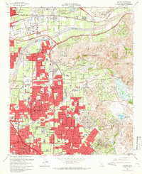
 1968 El Toro1970 Print · USGSOrange County's mix of military expansion and rural canyon life is captured here during the late sixties. Researchers can trace the massive El Toro Marine Corps Air Station, find old family plots at Ascension Cem, and see the early International Raceway.9 unique versions available
End of results
Showing maps 1-9 of 9
Top cities near Irvine
- Anaheim historical maps
- Santa Ana historical maps
- Huntington Beach historical maps
- Garden Grove historical maps
- Corona historical maps
- Fullerton historical maps
See more
Top neighborhoods of Irvine
- Stonegate East historical maps
- Quail Hill - Open Space historical maps
- Rancho San Joaquin historical maps
- Stonegate historical maps
- Kathryn historical maps
- Woodbridge historical maps
See more
Frequently asked questions
- What are the different types of historical maps available for Irvine?
- What is the oldest map of Irvine?
- Where can I purchase historical maps of Irvine for my home or office?
- Where can I download high-res historical maps of Irvine?
- Are there historical topographic maps available for Irvine?
- Is there historical aerial imagery available for Irvine?
- Where are historical maps of Irvine sourced from?