Old Maps of Irvine, California for Metal Detecting
Plan your next treasure hunt with 76 historic maps of Irvine. Find old homesites, ghost towns, trails, and gathering spots that may be lost to time — perfect for identifying promising metal detecting locations.
- Locate forgotten sites: Uncover places like long-lost settlements, abandoned rail lines, or gathering spots.
- Plan better hunts: Use map overlays combined with LiDAR or satellite views to narrow in on historically rich areas.
- Made for detectorists: Thousands of hobbyists use these maps to discover relics, coins, and hidden history.
Use these historic maps to boost your research and find new opportunities beneath the surface of Irvine.
Irvine, CA maps
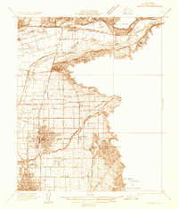
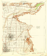
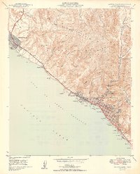
(76)- 1896 Map of Santa Ana
 1896 Santa Ana1896 Print · USGSOrange County was still a land of vast ranchos and emerging citrus towns in the 1890s, well before the post-war suburban boom. You can trace early rail lines like the SANTA ANA AND NEWPORT R. R. and locate vanished coastal landmarks near Arch Beach and Newport Bay.2 unique versions available
 - 1896 Map of Anaheim
 1896 Anaheim1896 Print · USGSThe Orange County basin appears here in the mid-1890s, when iron rails first connected the young citrus towns to the wider world. Genealogists and researchers can trace the early grids of Anaheim, Fullerton, and Orange alongside now-obscure rail stops like Almond and Marlboro.
 - 1898 Map of Anaheim, 1899 Print
 1898 Anaheim1899 Print · USGSNorthern Orange County is captured here at the height of its citrus and rail era. Genealogists and local historians can trace the early footprints of Anaheim, Fullerton, and Orange, alongside smaller vanished stops like McPherson and Almond.
 - 1901 Map of Southern California Sheet No. 1
 1901 Southern California Sheet No. 11901 Print · USGSGreater Los Angeles at the dawn of the twentieth century is a landscape of growing citrus towns and a burgeoning rail network. Genealogists and historians can trace the early gridded streets of Hollywood and Pasadena or locate landmarks like Bear Lake and the Cahuilla Indian Reservation.6 unique versions available
 - 1901 Map of Santa Ana
 1901 Santa Ana1901 Print · USGSThe Orange County coast and plains appear here at the dawn of the twentieth century, during a period of agricultural and rail expansion. Genealogists can trace early homesteads near Fairview or locate early rail stops at Smeltzer and Wintersburg.6 unique versions available
 - 1901 Map of Anaheim
 1901 Anaheim1901 Print · USGSOrange County's citrus and rail heartland is meticulously detailed at the start of the century, showing the early layouts of Anaheim and Fullerton. Genealogists can trace early homesteads and rail stops like Loara, Miraflores, and Olinda.6 unique versions available
 - 1902 Map of Corona
 1902 Corona1902 Print · USGSThe Orange County and Riverside borderlands at the start of the 1900s show an era of rapid rail expansion and water engineering. Researchers can trace the early footprints of Anaheim and Orange or find vanished industry at the Santiago Coal Mine.7 unique versions available
 - 1904 Map of Southern California Sheet No. 1, 1905 Print
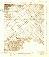
 1904 Southern California Sheet No. 11905 Print · USGSSouthern California at the dawn of the twentieth century shows a landscape of citrus groves and coastal towns connected by rail. Genealogists and historians can trace early settlements like San Juan Capistrano, find remote sites like the Rose Mine, and study the original water systems of the Santa Ana River.2 unique versions available
 - 1932 Map of Orange
 1932 Orange1932 Print · USGSOrange County was a landscape of expanding citrus groves and irrigation works in the early thirties. Local researchers can trace the development of established city grids and outlying communities like Atwood, McPherson, and El Modena alongside the Santa Ana River.
 - 1932 Map of Tustin
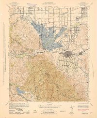
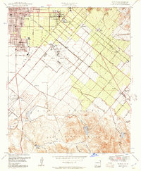
 1932 Tustin1932 Print · USGSOrange County in the early thirties reveals a landscape of massive ranch lands and pioneer aviation. Genealogists and historians can trace the foundations of Tustin and Irvine, identifying local landmarks like the Irvine Ranch Headquarters and the Delhi post office.
 - 1935 Map of Tustin
 1935 Tustin1935 Print · USGSThe citrus groves and ranch lands of Orange County are captured here in the mid-1930s, showing the early footprints of Tustin and Irvine. Trace the local rail-and-ranch economy through features like the Irvine Ranch Headquarters, Delhi (Glorietta PO), and Martins Landing Field.3 unique versions available
 - 1935 Map of El Toro
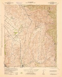
 1935 El Toro1935 Print · USGSOrange County ranching culture thrives in the 1930s, centered on the settlement of El Toro and the surrounding canyon washes. Researchers can trace early infrastructure along the Atchison Topeka and Santa Fe railroad and locate historic homesteads like Moulton Ranch and Serrano Place.4 unique versions available
 - 1935 Map of Orange
 1935 Orange1935 Print · USGSOrange County's citrus-rich heartland is captured in the mid-1930s, revealing a landscape of burgeoning towns and vital rail lines. Genealogists can trace early homesteads near St Johns Cem, the Villa Park Sch, and the El Modena Sta.2 unique versions available
 - 1942 Map of Anaheim
 1942 Anaheim1942 Print · USGSOrange County's agricultural heart is captured mid-century during a period of rapid wartime development. Genealogists can locate family landmarks like Diamond Bar Ranch, local schools such as Alamitos Sch, and communities like Garden Grove or Stanton.2 unique versions available
 - 1942 Map of Santa Ana
 1942 Santa Ana1942 Print · USGSOrange County was still a landscape of coastal towns and sprawling citrus groves during the early years of the war. Genealogists and researchers can trace the early footprints of Costa Mesa, the rail-side industry of Sugar, and the distinct shorelines of Newport Bay.2 unique versions available
 - 1942 Map of Santiago Peak, 1943 Print
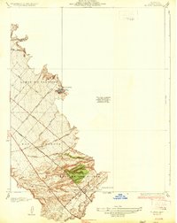
 1942 Santiago Peak1943 Print · USGSOrange County and the inland canyons appear here in the early 1940s, showing a landscape of small settlements and rugged mountain reaches. Genealogists and local historians can trace early holdings near San Juan Capistrano, the station at El Toro, and mountain landmarks like Modjeska.3 unique versions available
 - 1942 Map of Corona, 1947 Print
 1942 Corona1947 Print · USGSRiverside County at the dawn of the 1940s reveals a unique mix of agricultural roots, mountain canyons, and significant regional infrastructure projects. Genealogists and local historians can trace the early street plans of Corona and Norco, or locate landmarks like the East Vale Sch and the Santiago Reservoir.2 unique versions available
 - 1943 Map of Corona
 1943 Corona1943 Print · USGSThe Santa Ana River valley during the mid-forties shows a landscape shaped by water management and early inland growth. Trace the development of Corona and Norco alongside the massive Prado Dam and local landmarks like the East Vale Sch.
 - 1947 Map of Santa Ana, 1949 Print
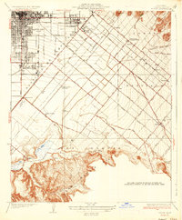
 1947 Santa Ana1949 Print · USGSSouthern California is depicted here in the late forties, showing the expansion of the Inland Empire and the Orange County coast. Researchers can trace the early layout of Palm Springs or locate long-standing tribal lands like the Pala Indian Reservation and Rincon Indian Res.
 - 1948 Map of Tustin, 1957 Print
 1948 Tustin1957 Print · USGSOrange County's agricultural heart was beginning to transform after the war as Tustin and the Irvine Ranch expanded toward the coast. Researchers can trace historic landmarks like Orange County Airport, the Naval Reservation, and old school sites like Delhi Sch.2 unique versions available
 - 1948 Map of Laguna Beach, 1957 Print
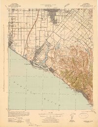
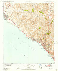 1948 Laguna Beach1957 Print · USGSPost-war Orange County comes to life as Laguna Beach and Corona del Mar begin their modern growth along the Pacific. Researchers can trace the development of coastal coves and interior landmarks like Top of the World, Crystal Cove, and Canyon Acres.2 unique versions available
 - 1948 Map of San Juan Capistrano, 1957 Print
 1948 San Juan Capistrano1957 Print · USGSSouthern Orange County appears in the late 1940s as a land of expansive ranching grants and quiet valley settlements. You can trace the historic Mission at San Juan Capistrano, the winding Atchison Topeka and Santa Fe rail line, and early coastal life near South Laguna.3 unique versions available
 - 1949 Map of San Juan Capistrano
 1949 San Juan Capistrano1949 Print · USGSCoastal Orange County in the late 1940s retains its pastoral character, centered on the historic Mission at San Juan Capistrano. Genealogists and local historians can trace the early rail-and-road corridor of the Atchison Topeka and Santa Fe and the original Ortega Highway.
 - 1949 Map of Laguna Beach
 1949 Laguna Beach1949 Print · USGSThe Orange County coast appears in its postwar infancy, where the cliffs and canyons of the SAN JOAQUIN HILLS meet the Pacific. Researchers can trace early residential growth at Corona del Mar and locate local landmarks like the Art Gallery and Rancho Laguna Sch.2 unique versions available
 - 1949 Map of Santa Ana
 1949 Santa Ana1949 Print · USGSSouthern California underwent a profound transformation in the late 1940s as military installations and citrus groves shared the landscape. Researchers can trace early coastal growth at Laguna Beach, military history at Camp Pendleton, and the rail corridors of the Pacific Electric.
Showing maps 1-25 of 76
Top cities near Irvine
- Anaheim historical maps
- Santa Ana historical maps
- Huntington Beach historical maps
- Garden Grove historical maps
- Corona historical maps
- Fullerton historical maps
See more
Top neighborhoods of Irvine
- Stonegate East historical maps
- Quail Hill - Open Space historical maps
- Rancho San Joaquin historical maps
- Stonegate historical maps
- Kathryn historical maps
- Woodbridge historical maps
See more
Frequently asked questions
- What are the different types of historical maps available for Irvine?
- What is the oldest map of Irvine?
- Where can I purchase historical maps of Irvine for my home or office?
- Where can I download high-res historical maps of Irvine?
- Are there historical topographic maps available for Irvine?
- Is there historical aerial imagery available for Irvine?
- Where are historical maps of Irvine sourced from?