1970s Maps of San Juan Capistrano, California
Explore 4 historic maps of San Juan Capistrano from the 1970s. These maps offer a rare glimpse into what life looked like during the 1970s — showing old roads, neighborhoods, homes, and landmarks that have changed or disappeared over time.
Whether you're researching your family's past, planning a metal detecting trip, or studying how San Juan Capistrano's landscape evolved across the 1970s, these high-resolution maps are a powerful tool for exploring the history of this region.
- Focus on a specific era: All maps on this page are from the 1970s, giving you a focused view of this time period.
- See what’s changed: Compare century-old streets, trails, and buildings to today's modern landscape using overlays and satellite layers.
- Research with precision: Use these maps for genealogy, historical research, land use analysis, or educational projects.
- View, download, or print: Maps are fully viewable online in high resolution, and can be downloaded or printed for your own records.
Start exploring San Juan Capistrano's history through authentic maps from the 1970s. This is your window into the past.
San Juan Capistrano, CA maps
(4)- 1974 Map of San Clemente, 1975 Print
 1974 San Clemente1975 Print · USGSCoastal Orange County meets the sprawling training grounds of the Marines in the mid-seventies. Researchers can trace the rugged topography of Gabino Canyon and the coastal interface at Camp Pendleton Marine Corps Base.2 unique versions available
 - 1974 Map of Canada Gobernadora, 1977 Print
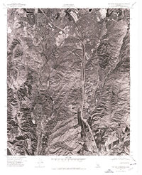
 1974 Canada Gobernadora1977 Print · USGSSouthern Orange County appears in detailed 1970s aerial photography, showcasing the rural canyon systems before suburban expansion. Trace the natural paths of Cañada Gobernadora, Gabino Canyon, and Lucas Canyon across the landscape.
 - 1974 Map of Dana Point, 1977 Print
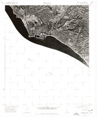 1974 Dana Point1977 Print · USGSCoastal Orange County is captured in the mid-1970s during a decade of rapid suburban transformation. Local historians can trace the early harbor structures at Dana Point and the residential footprint of San Clemente along the Pacific Ocean.
 - 1974 Map of San Juan Capistrano, 1977 Print
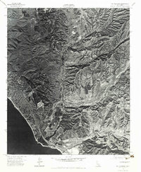
 1974 San Juan Capistrano1977 Print · USGSCoastal Orange County undergoes a period of rapid suburban growth in the mid-1970s, as seen from this unique aerial perspective. Researchers can trace the early development of modern residential tracts and infrastructure surrounding the historic San Juan Capistrano.
End of results
Showing maps 1-4 of 4
Top cities near San Juan Capistrano
- Santa Ana historical maps
- Irvine historical maps
- Oceanside historical maps
- Costa Mesa historical maps
- Mission Viejo historical maps
- Newport Beach historical maps
See more
Top neighborhoods of San Juan Capistrano
Frequently asked questions
- What are the different types of historical maps available for San Juan Capistrano?
- What is the oldest map of San Juan Capistrano?
- Where can I purchase historical maps of San Juan Capistrano for my home or office?
- Where can I download high-res historical maps of San Juan Capistrano?
- Are there historical topographic maps available for San Juan Capistrano?
- Is there historical aerial imagery available for San Juan Capistrano?
- Where are historical maps of San Juan Capistrano sourced from?