1970s Maps of Placer County, California
Explore 6 historic maps of Placer County from the 1970s. These maps offer a rare glimpse into what life looked like during the 1970s — showing old roads, neighborhoods, homes, and landmarks that have changed or disappeared over time.
Whether you're researching your family's past, planning a metal detecting trip, or studying how Placer County's landscape evolved across the 1970s, these high-resolution maps are a powerful tool for exploring the history of this region.
- Focus on a specific era: All maps on this page are from the 1970s, giving you a focused view of this time period.
- See what’s changed: Compare century-old streets, trails, and buildings to today's modern landscape using overlays and satellite layers.
- Research with precision: Use these maps for genealogy, historical research, land use analysis, or educational projects.
- View, download, or print: Maps are fully viewable online in high resolution, and can be downloaded or printed for your own records.
Start exploring Placer County's history through authentic maps from the 1970s. This is your window into the past.
Placer County, CA maps
(6)- 1975 Map of Citrus Heights, 1977 Print
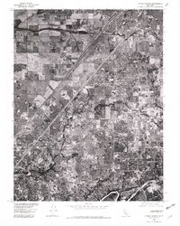 1975 Citrus Heights1977 Print · USGSSacramento's northern suburbs are captured in the mid-seventies just as development began to fill the gaps between historic communities. Genealogists and local historians can trace street-level detail through Citrus Heights, Fair Oaks, and Carmichael.2 unique versions available
 - 1975 Map of Folsom, 1978 Print
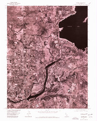 1975 Folsom1978 Print · USGSGreater Sacramento's transition toward modern suburban development is captured in the mid-1970s through this detailed aerial survey. Trace the growth of Folsom and Orangevale alongside the massive engineering of Folsom Lake and Lake Natoma.
 - 1975 Map of Rio Linda, 1978 Print
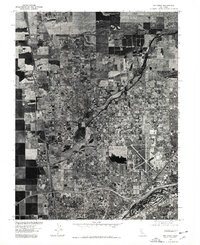 1975 Rio Linda1978 Print · USGSThe Sacramento Valley in the mid-seventies shows a landscape of steady suburban transition. Trace the mid-century footprint of McClellan Air Force Base and the developing street patterns of Rio Linda and North Highlands.
 - 1975 Map of Auburn, 1981 Print
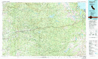
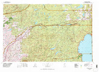
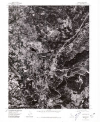 1975 Auburn1981 Print · USGSThe Placer County foothills in the mid-seventies are documented here through high-resolution aerial photography. Genealogists and historians can trace the footprint of Auburn, the Dewitt State Hospital grounds, and outlying locales like Clipper Gap.
 - 1976 Map of Placerville, 1994 Print
 1976 Placerville1994 Print · USGSEl Dorado County and the high Sierra Nevada are captured in the mid-seventies, showing the evolution of the Mother Lode from its mining roots to a modern recreational and timber hub. Genealogists can locate family names and old landmarks like Old Fort Jim, the Shingle Springs Indian Reservation, and the historic town of Fiddletown.2 unique versions available
 - 1977 Map of Truckee, 1978 Print
 1977 Truckee1978 Print · USGSThe High Sierra and Lake Tahoe regions come into focus in the late seventies, showing a landscape defined by massive reservoir projects and mountain transit. Genealogists and historians can trace the Southern Pacific rail line through Truckee or explore old mining districts near North Bloomfield and Colfax.2 unique versions available
End of results
Showing maps 1-6 of 6
Top cities of Placer County
- Roseville historical maps
- Rocklin historical maps
- Lincoln historical maps
- Auburn historical maps
- Loomis historical maps
- Meadow Vista historical maps
See more
Frequently asked questions
- What are the different types of historical maps available for Placer County?
- What is the oldest map of Placer County?
- Where can I purchase historical maps of Placer County for my home or office?
- Where can I download high-res historical maps of Placer County?
- Are there historical topographic maps available for Placer County?
- Is there historical aerial imagery available for Placer County?
- Where are historical maps of Placer County sourced from?