1990s Maps of Placer County, California
Explore 18 historic maps of Placer County from the 1990s. These maps offer a rare glimpse into what life looked like during the 1990s — showing old roads, neighborhoods, homes, and landmarks that have changed or disappeared over time.
Whether you're researching your family's past, planning a metal detecting trip, or studying how Placer County's landscape evolved across the 1990s, these high-resolution maps are a powerful tool for exploring the history of this region.
- Focus on a specific era: All maps on this page are from the 1990s, giving you a focused view of this time period.
- See what’s changed: Compare century-old streets, trails, and buildings to today's modern landscape using overlays and satellite layers.
- Research with precision: Use these maps for genealogy, historical research, land use analysis, or educational projects.
- View, download, or print: Maps are fully viewable online in high resolution, and can be downloaded or printed for your own records.
Start exploring Placer County's history through authentic maps from the 1990s. This is your window into the past.
Placer County, CA maps
(18)- 1992 Map of Homewood, 1994 Print
 1992 Homewood1994 Print · USGSThe western shores of Lake Tahoe come alive in the 1990s, showcasing the classic resorts and dense forest wilderness of the Sierra Nevada. Trace the early trails and shoreline settlements like Idlewild, find the route of the Pacific Crest National Scenic Trail, and locate high-altitude landmarks like Eagle Rock.2 unique versions available
 - 1992 Map of Meeks Bay, 1994 Print
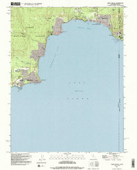
 1992 Meeks Bay1994 Print · USGSThe West Shore of Lake Tahoe in the early nineties reveals a landscape of lakeside communities and protected state parklands. Researchers can trace the development of Tahoma, locate the historic Ehrman Mansion, and identify recreation sites like Meeks Bay Campground.
 - 1992 Map of Martis Peak, 1994 Print
 1992 Martis Peak1994 Print · USGSThe Sierra Nevada high country comes into focus in the early nineties as classic timber lands gave way to year-round recreation. Trace the history of the Union Mills (Site), the summit at Martis Peak, and the early layout of Northstar-at-Tahoe.2 unique versions available
 - 1992 Map of Kings Beach, 1994 Print
 1992 Kings Beach1994 Print · USGSThe North Shore of Lake Tahoe comes into focus in the early nineties, showing the established communities of Kings Beach and Carnelian Bay. Trace the local development and landmarks like the Fish Hatchery, Brockway Spring, and Dollar Reservoir.2 unique versions available
 - 1992 Map of Tahoe City, 1994 Print
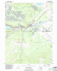
 1992 Tahoe City1994 Print · USGSLake Tahoe and the Truckee River corridor appear here in the early nineties as the region's world-class ski infrastructure reached its peak. Researchers can trace the development of Squaw Valley USA, locate the Cem at Tahoe City, or find high-country landmarks like Watson Lake.2 unique versions available
 - 1992 Map of Truckee, 1994 Print
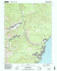
 1992 Truckee1994 Print · USGSTruckee and the surrounding Sierra Nevada highlands are shown in the early nineties, centered on the vital rail and river crossing. Historians can trace the Emigrant Road Trail and locate significant sites like the Murphy Cabin (Site) and Joerger Ranch.2 unique versions available
 - 1992 Map of Lincoln, 1997 Print
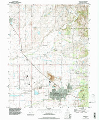 1992 Lincoln1997 Print · USGSPlacer County's valley floor comes into focus in the early nineties, showing a landscape of agriculture and clay production. Trace the historical footprints of Chamberlain Ranch, the workings at the Claypit, and the quiet grounds of Manzanita Cemetery.2 unique versions available
 - 1992 Map of Sheridan, 1997 Print
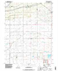 1992 Sheridan1997 Print · USGSSheridan and the surrounding Placer County ranchlands are captured here in the early nineties, revealing a landscape of managed water and historic land grants. Researchers can trace irrigation networks along Yankee Slough and the borders of the Johnson Rancho.
 - 1992 Map of Rio Linda, 1997 Print
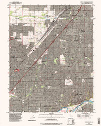
 1992 Rio Linda1997 Print · USGSThe northern Sacramento suburbs and the massive Mc Clellan Air Force Base are shown here in the early nineties. Researchers can trace the development of Rio Linda, locate the Sunset Lawn Cemetery, or find rural landmarks like the Elverta Switchyard.
 - 1992 Map of Citrus Heights, 1997 Print
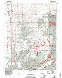
 1992 Citrus Heights1997 Print · USGSGreater Sacramento's northeastern suburbs were rapidly maturing in the early nineties, showing a dense grid of neighborhoods between Roseville and the American River. Researchers can trace the perimeter of Mc Clellan Air Force Base and locate local landmarks like American River College and Sylvan Corners.
 - 1992 Map of Roseville, 1997 Print
 1992 Roseville1997 Print · USGSRoseville and Rocklin are shown during a phase of rapid transition in the early nineties, where historical ranching meets modern suburban development. Genealogists and local historians can trace the W F Fiddyment Ranch, locate the Roseville Cemetery, or follow the Southern Pacific rail lines.
 - 1993 Map of Yuba City, 1994 Print
 1993 Yuba City1994 Print · USGSThe Sacramento Valley and Sierra Nevada foothills meet in the 1990s, where agricultural bypasses and river networks surround the iconic Sutter Buttes. Researchers can trace the rail corridors of the Southern Pacific and Western Pacific through hubs like Marysville and Gridley.
 - 1994 Map of Sacramento
 1994 Sacramento1994 Print · USGSThe Sacramento valley was a landscape of massive flood control and military aviation during the mid-nineties. Researchers can trace the complex network of the Yolo Bypass and the Sacramento River alongside McClellan Air Force Base and Zamora.2 unique versions available
 - 1995 Map of Camp Far West
 1995 Camp Far West1995 Print · USGSYuba and Placer counties meet here in the mid-nineties, where the foothills rise above the sprawling airfield and the reservoir. Researchers can trace the Overland Emigrant Road and locate historical landmarks like Spenceville and the Lofton Cem.
 - 1995 Map of Lake Combie
 1995 Lake Combie1995 Print · USGSThe Sierra Nevada foothills emerge in the mid-nineties as a blend of suburban growth and historic water systems. Genealogists and historians can trace the Overland Emigrant Road and locate the Stockton Hill Mine near Lake Combie.
 - 1995 Map of Wolf
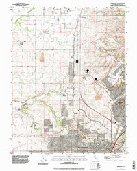
 1995 Wolf1995 Print · USGSThe Nevada and Placer county line comes alive in the mid-1990s as it follows the winding Bear River through the Sierra foothills. Researchers can trace historic sites like Garden Bar and Wolf, the operations at Pine Hill Mine, and the modern Combie Aqueduct.
 - 1998 Map of Lake Combie, 2002 Print
 1998 Lake Combie2002 Print · USGSNorthern California hill country at the turn of the millennium shows a fascinating mix of pioneer trails and modern water management. Trace the historic Overland Emigrant Road past the Stockton Hill Mine or the shores of Lake of the Pines.
 - 1998 Map of Wolf, 2002 Print
 1998 Wolf2002 Print · USGSThe Nevada and Placer county borderlands in the late nineties are defined by foothill ranching and water infrastructure. Trace historic paths like Emigrant Road, find the Pine Hill Mine, and locate old settlements at Wolf and Garden Bar.
End of results
Showing maps 1-18 of 18
Top cities of Placer County
- Roseville historical maps
- Rocklin historical maps
- Lincoln historical maps
- Auburn historical maps
- Loomis historical maps
- Meadow Vista historical maps
See more
Frequently asked questions
- What are the different types of historical maps available for Placer County?
- What is the oldest map of Placer County?
- Where can I purchase historical maps of Placer County for my home or office?
- Where can I download high-res historical maps of Placer County?
- Are there historical topographic maps available for Placer County?
- Is there historical aerial imagery available for Placer County?
- Where are historical maps of Placer County sourced from?