1900-1909 Maps of Sacramento, California
Explore 4 historic maps of Sacramento from 1900-1909. These maps offer a rare glimpse into what life looked like during the 1900s — showing old roads, neighborhoods, homes, and landmarks that have changed or disappeared over time.
Whether you're researching your family's past, planning a metal detecting trip, or studying how Sacramento's landscape evolved across the 1900s, these high-resolution maps are a powerful tool for exploring the history of this region.
- Focus on a specific era: All maps on this page are from the 1900s, giving you a focused view of this time period.
- See what’s changed: Compare century-old streets, trails, and buildings to today's modern landscape using overlays and satellite layers.
- Research with precision: Use these maps for genealogy, historical research, land use analysis, or educational projects.
- View, download, or print: Maps are fully viewable online in high resolution, and can be downloaded or printed for your own records.
Start exploring Sacramento's history through authentic maps from the 1900s. This is your window into the past.
Sacramento, CA maps
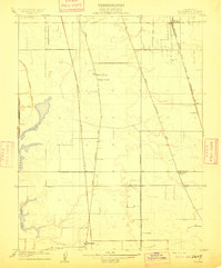
(4)- 1902 Map of Fairoaks
 1902 Fairoaks1902 Print · USGSSacramento and its surrounding ranchlands were undergoing a rapid rail-driven transformation at the start of the century. You can trace the early street grids of Oak Park and Highland Park or locate vanished stops like Twelvemile House and Walsh Station.2 unique versions available
 - 1907 Map of Davisville
 1907 Davisville1907 Print · USGSYolo and Sacramento counties are captured here at a pivot point for river transit and rail growth. Researchers can trace early rural life via the Lisbon School, Taylor Monument Datey's Ferry, and the original footprint of Davisville.2 unique versions available
 - 1908 Map of Courtland
 1908 Courtland1908 Print · USGSThe Sacramento Delta at the dawn of the twentieth century was a landscape of fertile river islands and vital waterborne transit. Genealogists and historians can trace the early footprints of Courtland, Clarksburg, and Freeport, or locate landmarks like the Free County Ferry and Indian Mound.3 unique versions available
 - 1909 Map of Florin
 1909 Florin1909 Print · USGSSacramento County rural life is captured in the early twentieth century as the valley floor was being shaped by railroads and irrigation. Genealogists can locate family landmarks like Union House and Prairie School or trace the early paths of Upper Stockton Road.2 unique versions available
End of results
Showing maps 1-4 of 4
Top cities near Sacramento
- Elk Grove historical maps
- Roseville historical maps
- Citrus Heights historical maps
- Davis historical maps
- Rancho Cordova historical maps
- Woodland historical maps
See more
Top neighborhoods of Sacramento
- Pollock historical maps
- Elvas historical maps
- Del Paso historical maps
- Hagginwood historical maps
- Robla historical maps
- North Sacramento historical maps
See more
Frequently asked questions
- What are the different types of historical maps available for Sacramento?
- What is the oldest map of Sacramento?
- Where can I purchase historical maps of Sacramento for my home or office?
- Where can I download high-res historical maps of Sacramento?
- Are there historical topographic maps available for Sacramento?
- Is there historical aerial imagery available for Sacramento?
- Where are historical maps of Sacramento sourced from?