1910s Maps of Sacramento, California
Explore 7 historic maps of Sacramento from the 1910s. These maps offer a rare glimpse into what life looked like during the 1910s — showing old roads, neighborhoods, homes, and landmarks that have changed or disappeared over time.
Whether you're researching your family's past, planning a metal detecting trip, or studying how Sacramento's landscape evolved across the 1910s, these high-resolution maps are a powerful tool for exploring the history of this region.
- Focus on a specific era: All maps on this page are from the 1910s, giving you a focused view of this time period.
- See what’s changed: Compare century-old streets, trails, and buildings to today's modern landscape using overlays and satellite layers.
- Research with precision: Use these maps for genealogy, historical research, land use analysis, or educational projects.
- View, download, or print: Maps are fully viewable online in high resolution, and can be downloaded or printed for your own records.
Start exploring Sacramento's history through authentic maps from the 1910s. This is your window into the past.
Sacramento, CA maps
(7)- 1911 Map of Brighton
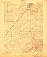
 1911 Brighton1911 Print · USGSSacramento and its eastern outskirts are captured in the early twentieth century during a period of rapid rail and agricultural expansion. Local historians can trace the early city grid out to New Helvetia or locate rural sites like Whisky Hill and Elder Creek School.2 unique versions available
 - 1911 Map of Mills
 1911 Mills1911 Print · USGSSacramento County ranch lands and rail stops are captured here in the early 1900s, just as the region was developing south of the American River. Trace the old Southern Pacific corridor through historic stops like Routier, Walsh Station, and Twelvemile House.
 - 1911 Map of Arcade
 1911 Arcade1911 Print · USGSNorth of Sacramento in the early 1900s, the landscape was being reshaped by a dense network of competing railroads and emerging rural communities. Local historians can trace the early footprints of Elverta and Robla alongside landmarks like the Oak Grove School and the Northern Electric line.2 unique versions available
 - 1911 Map of Antelope
 1911 Antelope1911 Print · USGSThe Placer and Sacramento county borderlands are captured here just after the turn of the century, centered on the growing rail hub at Roseville. Genealogists and local historians can trace early school districts at Sylvan and San Juan, and locate the historic Twelvemile House along the Auburn Road.
 - 1915 Map of Elkhorn Weir
 1915 Elkhorn Weir1915 Print · USGSThe Sacramento Valley in the early 1900s was a landscape defined by the river and its vast basins. Genealogists and historians can trace early landings and river crossings at Datey's Ferry, Mound Ranch, and the Elkhorn Weir.
 - 1916 Map of Lovdal
 1916 Lovdal1916 Print · USGSNear the confluence of the American and Sacramento Rivers in the early 1900s, this area shows a landscape defined by levees and early rail lines. Genealogists and historians can locate the Lisbon School, the Washington Broderick P O, and industry at the Brickyard.
 - 1916 Map of Babel Slough
 1916 Babel Slough1916 Print · USGSYolo and Sacramento counties meet along the river in the early twentieth century, showing a landscape defined by water and new reclamation canals. Genealogists and local historians can trace riverfront settlements at Clarksburg and Freeport, find the Free County Ferry, and locate the Indian Mound near Big Lake.
End of results
Showing maps 1-7 of 7
Top cities near Sacramento
- Elk Grove historical maps
- Roseville historical maps
- Citrus Heights historical maps
- Davis historical maps
- Rancho Cordova historical maps
- Woodland historical maps
See more
Top neighborhoods of Sacramento
- Pollock historical maps
- Elvas historical maps
- Del Paso historical maps
- Hagginwood historical maps
- Robla historical maps
- North Sacramento historical maps
See more
Frequently asked questions
- What are the different types of historical maps available for Sacramento?
- What is the oldest map of Sacramento?
- Where can I purchase historical maps of Sacramento for my home or office?
- Where can I download high-res historical maps of Sacramento?
- Are there historical topographic maps available for Sacramento?
- Is there historical aerial imagery available for Sacramento?
- Where are historical maps of Sacramento sourced from?