1970s Maps of Sacramento, California
Explore 2 historic maps of Sacramento from the 1970s. These maps offer a rare glimpse into what life looked like during the 1970s — showing old roads, neighborhoods, homes, and landmarks that have changed or disappeared over time.
Whether you're researching your family's past, planning a metal detecting trip, or studying how Sacramento's landscape evolved across the 1970s, these high-resolution maps are a powerful tool for exploring the history of this region.
- Focus on a specific era: All maps on this page are from the 1970s, giving you a focused view of this time period.
- See what’s changed: Compare century-old streets, trails, and buildings to today's modern landscape using overlays and satellite layers.
- Research with precision: Use these maps for genealogy, historical research, land use analysis, or educational projects.
- View, download, or print: Maps are fully viewable online in high resolution, and can be downloaded or printed for your own records.
Start exploring Sacramento's history through authentic maps from the 1970s. This is your window into the past.
Sacramento, CA maps
(2)- 1975 Map of Citrus Heights, 1977 Print
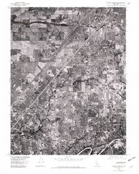 1975 Citrus Heights1977 Print · USGSSacramento's northern suburbs are captured in the mid-seventies just as development began to fill the gaps between historic communities. Genealogists and local historians can trace street-level detail through Citrus Heights, Fair Oaks, and Carmichael.2 unique versions available
 - 1975 Map of Rio Linda, 1978 Print
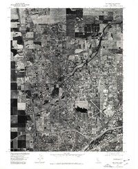 1975 Rio Linda1978 Print · USGSThe Sacramento Valley in the mid-seventies shows a landscape of steady suburban transition. Trace the mid-century footprint of McClellan Air Force Base and the developing street patterns of Rio Linda and North Highlands.
End of results
Showing maps 1-2 of 2
Top cities near Sacramento
- Elk Grove historical maps
- Roseville historical maps
- Citrus Heights historical maps
- Davis historical maps
- Rancho Cordova historical maps
- Woodland historical maps
See more
Top neighborhoods of Sacramento
- Pollock historical maps
- Elvas historical maps
- Del Paso historical maps
- Hagginwood historical maps
- Robla historical maps
- North Sacramento historical maps
See more
Frequently asked questions
- What are the different types of historical maps available for Sacramento?
- What is the oldest map of Sacramento?
- Where can I purchase historical maps of Sacramento for my home or office?
- Where can I download high-res historical maps of Sacramento?
- Are there historical topographic maps available for Sacramento?
- Is there historical aerial imagery available for Sacramento?
- Where are historical maps of Sacramento sourced from?