1900s (20th Century) Maps of San Benito County, California
Explore 98 historic maps of San Benito County from the 1900s (20th Century). These maps offer a rare glimpse into what life looked like during the 1900s — showing old roads, neighborhoods, homes, and landmarks that have changed or disappeared over time.
Whether you're researching your family's past, planning a metal detecting trip, or studying how San Benito County's landscape evolved across the 1900s, these high-resolution maps are a powerful tool for exploring the history of this region.
- Focus on a specific era: All maps on this page are from the 1900s, giving you a focused view of this time period.
- See what’s changed: Compare century-old streets, trails, and buildings to today's modern landscape using overlays and satellite layers.
- Research with precision: Use these maps for genealogy, historical research, land use analysis, or educational projects.
- View, download, or print: Maps are fully viewable online in high resolution, and can be downloaded or printed for your own records.
Start exploring San Benito County's history through authentic maps from the 1900s. This is your window into the past.
San Benito County, CA maps
(98)- 1913 Map of Panoche
 1913 Panoche1913 Print · USGSThe San Joaquin Valley and its ranching foothills appear in the early twentieth century before modern expansion. Genealogists can find remote rural schools and outposts like Mercy School, Laguna Seca Ranch, and the Mercy Mine.4 unique versions available
 - 1915 Map of Soledad
 1915 Soledad1915 Print · USGSThe Salinas Valley is captured in the early twentieth century as irrigation and the railroad transformed old land grants. Trace early settlements and rural schoolhouses like Fort Romie School and Paraiso Springs School alongside the Southern Pacific line.4 unique versions available
 - 1915 Map of Priest Valley
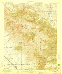
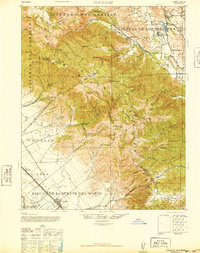
 1915 Priest Valley1915 Print · USGSCoastal range life in the early 1900s centered on remote mines and valley ranching hubs. Researchers can trace rural school districts like Columbus School and explore early mining operations such as the Monterey Coalmine or the New Idria Idria P O.5 unique versions available
 - 1915 Map of San Juan Bautista
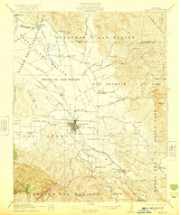
 1915 San Juan Bautista1915 Print · USGSCentral Coast agriculture and railroad expansion converge in this 1910s study of the Pajaro Valley. Local historians can trace the Southern Pacific line past Watsonville Junction to the Mission San Juan Bautista.
 - 1917 Map of San Juan Bautista
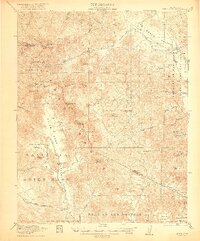
 1917 San Juan Bautista1917 Print · USGSThe fertile valleys of the Central Coast meet at the foot of the Santa Cruz Mountains during this era of agricultural expansion. Genealogists can trace family names across huge land grants and locate historic sites like Mission San Juan Bautista and the St Francis Orphan Asylum.6 unique versions available
 - 1919 Map of San Benito
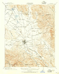
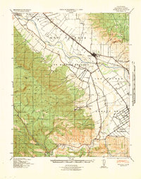
 1919 San Benito1919 Print · USGSSan Benito County in the decade after the Great War is a landscape of high ridges and remote ranching outposts. Genealogists and historians can trace the foundations of the local community through landmarks like Willow Creek School, the Bradford Mine, and the early borders of Pinnacles Nat Mon.2 unique versions available
 - 1919 Map of Hollister
 1919 Hollister1919 Print · USGSThe Santa Clara and San Benito county line area in the late nineteen-teens shows a landscape of expansive ranches and rural school districts. Genealogists can trace early homesteads and family names at Pacheco Ranch, San Justo School, and Dunneville.
 - 1921 Map of Gonzales
 1921 Gonzales1921 Print · USGSThe Gabilan Range and Salinas Valley come into sharp focus in the 1920s, revealing the transition from historic ranchos to a rail-connected agricultural economy. Researchers can trace early school sites like Willow Grove School, the operations at the Dolomite Quarry, and the original Southern Pacific route through Gonzales.5 unique versions available
 - 1921 Map of Metz
 1921 Metz1921 Print · USGSIn the early 1920s, the Salinas River valley served as a vital agricultural corridor between the Gabilan mountains and the coastal ranges. Researchers can trace historic landholdings like Coburn Ranch, locate the Metz School, and see the early footprint of Greenfield.4 unique versions available
 - 1921 Map of Hollister
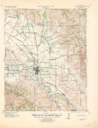
 1921 Hollister1921 Print · USGSThe San Benito and San Justo valleys come alive in this post-World War I era survey of the Hollister region. Researchers can trace family estates and early landmarks like the County Hospital, Barco Ranch, and the Southern Pacific rail line.4 unique versions available
 - 1922 Map of Quien Sabe
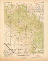
 1922 Quien Sabe1922 Print · USGSThe Diablo Range transitions from rugged peaks to vast historic land grants in the early twentieth century. Researchers can trace remote ranching sites like Buena Vista Ranch, the high-altitude Stayton Mine, and the local Quien Sabe School.4 unique versions available
 - 1923 Map of Monocline Ridge
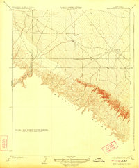 1923 Monocline Ridge1923 Print · USGSFresno County at the start of the twenties shows a landscape of developing industry and remote outposts. Researchers can locate the Tumey Gulch School and trace early petroleum infrastructure at the Oil Pumping Station along the base of Monocline Ridge.3 unique versions available
 - 1923 Map of Hollister, 1955 Print
 1923 Hollister1955 Print · USGSHollister and the surrounding San Benito valley are captured here in the early 1920s as the rail and agricultural networks were fully established. Genealogists can locate family holdings like Indart Ranch and numerous rural landmarks such as Enterprise School and the COUNTY HOSPITAL.
 - 1931 Map of San Benito
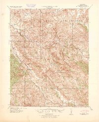
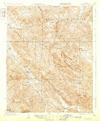 1931 San Benito1931 Print · USGSThe high ridges and deep river canyons of San Benito County are captured here in the early twentieth century. Genealogists and local historians can trace the remote Los Muertos Ranch, early rural schoolhouses like Emmett School, and the northern reaches of Pinnacles Nat Mon.2 unique versions available
 - 1939 Map of San Juan Bautista, 1958 Print
 1939 San Juan Bautista1958 Print · USGSThe Central Coast landscape at the dawn of World War II is documented here, showing the intersection of Spanish-era ranchos and the Southern Pacific rail line. Researchers can trace the grounds of Mission San Juan Bautista, identify the Sargent Oil Field, and locate numerous rural schoolhouses like Carlton School.
 - 1940 Map of San Juan Bautista
 1940 San Juan Bautista1940 Print · USGSCentral California coastal and valley life at the start of the 1940s is captured here, where four counties meet. Genealogy researchers can trace family-named sites like Patrick Breen, old rural institutions like the St Francis Orphan Asylum, and the early Sargent Oil Fields.
 - 1940 Map of Metz
 1940 Metz1940 Print · USGSThe Salinas River valley and the Gabilan Range come into sharp focus just before the war, showing the area's transition into a major agricultural corridor. Genealogists and historians can locate specific family landmarks like Schmidt Ranch, the Metz School, and early layouts of Greenfield.
 - 1940 Map of Hollister
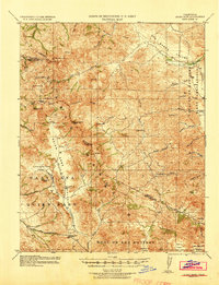
 1940 Hollister1940 Print · USGSSan Benito County is shown just before the war as a landscape of productive ranches and emerging civic infrastructure. Genealogists and local historians can trace rural school districts like Anasymas School and the Southern Pacific rail line through Tres Pinos.2 unique versions available
 - 1940 Map of Quien Sabe
 1940 Quien Sabe1940 Print · USGSThe San Benito and Merced county lines meet in this 1940 survey of the Diablo Range highlands and interior ranch lands. Researchers can trace the early property lines of the Real de las Aguilas, find the Stayton Mine, and locate the old Quien Sabe School.2 unique versions available
 - 1940 Map of Soledad
 1940 Soledad1940 Print · USGSThe Salinas Valley of the 1940s is shown here as a landscape of historic ranchos and rising agricultural industry. Genealogists and researchers can locate Mission Soledad (Ruins), the Camphora School, and family landmarks like the Olson Ranch.
 - 1940 Map of San Benito
 1940 San Benito1940 Print · USGSThe San Benito River valley in the early 1940s was a landscape of remote ranching and rural education. Genealogists can locate family-named outposts like Elkhorn Ranch and several country schools, including Cottonwood School and Emmett School.2 unique versions available
 - 1940 Map of Gonzales, 1947 Print
 1940 Gonzales1947 Print · USGSMonterey and San Benito counties meet in the high Gabilan Range during the pre-war era of ranching and early highway travel. Genealogy researchers can find the Paicines Ranch, tracing old schoolhouses like Paicines School and the rails of the Southern Pacific.
 - 1941 Map of Priest Valley
 1941 Priest Valley1941 Print · USGSThe high ridges and deep canyons of Monterey County are captured here just before the mid-century, documenting remote ranching outposts and early industrial sites. Genealogists and historians can trace old landmarks like the Stone Canyon Mine, the Priest Valley Sch, and the settlement at San Lorenzo (Randall).
 - 1941 Map of Gonzales
 1941 Gonzales1941 Print · USGSThe Salinas Valley meets the Gabilan Range in this early 1940s tactical survey of Monterey and San Benito Counties. Genealogists can locate rural landmarks like Paicines Ranch, Willow Grove School, and the Southern Pacific stop at Dean.
 - 1941 Map of San Ardo
 1941 San Ardo1941 Print · USGSThe Salinas River valley in the early 1940s was a landscape defined by the Southern Pacific rail line and ranching outposts. Genealogists and local historians can trace the rural infrastructure of Monterey County through the San Ardo townsite, the Lewis Creek Sch, and family landmarks like Casey Gulch.2 unique versions available
Showing maps 1-25 of 98
Top cities of San Benito County
Frequently asked questions
- What are the different types of historical maps available for San Benito County?
- What is the oldest map of San Benito County?
- Where can I purchase historical maps of San Benito County for my home or office?
- Where can I download high-res historical maps of San Benito County?
- Are there historical topographic maps available for San Benito County?
- Is there historical aerial imagery available for San Benito County?
- Where are historical maps of San Benito County sourced from?