1990s Maps of San Benito County, California
Explore 4 historic maps of San Benito County from the 1990s. These maps offer a rare glimpse into what life looked like during the 1990s — showing old roads, neighborhoods, homes, and landmarks that have changed or disappeared over time.
Whether you're researching your family's past, planning a metal detecting trip, or studying how San Benito County's landscape evolved across the 1990s, these high-resolution maps are a powerful tool for exploring the history of this region.
- Focus on a specific era: All maps on this page are from the 1990s, giving you a focused view of this time period.
- See what’s changed: Compare century-old streets, trails, and buildings to today's modern landscape using overlays and satellite layers.
- Research with precision: Use these maps for genealogy, historical research, land use analysis, or educational projects.
- View, download, or print: Maps are fully viewable online in high resolution, and can be downloaded or printed for your own records.
Start exploring San Benito County's history through authentic maps from the 1990s. This is your window into the past.
San Benito County, CA maps
(4)- 1995 Map of Hollister, 1998 Print
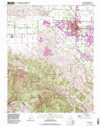 1995 Hollister1998 Print · USGSHollister and the surrounding San Juan Valley are captured here in the mid-nineties as the city expanded toward the Gabilan Range. Local historians can trace established landmarks like the IOOF Cem and San Benito Joint Union High Sch alongside the striking topography of the San Andreas Rift Zone.
 - 1995 Map of Watsonville East, 1998 Print
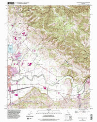 1995 Watsonville East1998 Print · USGSCoastal agriculture and mountainous terrain meet in the Pajaro Valley during the mid-nineties. Researchers can trace the Southern Pacific rail corridor through Watsonville Junction or locate family sites at Pajaro Valley Memorial Park and Johnston Corner.2 unique versions available
 - 1995 Map of North Chalone Peak, 1999 Print
 1995 North Chalone Peak1999 Print · USGSThe Monterey and San Benito county line crosses these high peaks of the Gabilan Range in the mid-nineties. Trace the trails and landmarks of Pinnacles National Monument, from Machete Ridge to the high lookout at North Chalone Peak.
 - 1997 Map of San Juan Bautista, 2002 Print
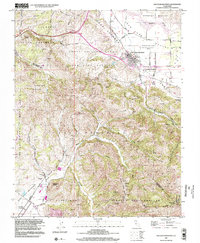 1997 San Juan Bautista2002 Print · USGSSan Juan Bautista and the San Benito Valley are shown here in the late twentieth century as they maintain their agricultural and missionary heritage. Genealogists and historians can trace the limits of old land grants and find landmarks like Mission San Juan Bautista, Lagunita Sch, and Fremont Peak.
End of results
Showing maps 1-4 of 4
Top cities of San Benito County
Frequently asked questions
- What are the different types of historical maps available for San Benito County?
- What is the oldest map of San Benito County?
- Where can I purchase historical maps of San Benito County for my home or office?
- Where can I download high-res historical maps of San Benito County?
- Are there historical topographic maps available for San Benito County?
- Is there historical aerial imagery available for San Benito County?
- Where are historical maps of San Benito County sourced from?