1990s Maps of Lucerne Valley, California
Explore 6 historic maps of Lucerne Valley from the 1990s. These maps offer a rare glimpse into what life looked like during the 1990s — showing old roads, neighborhoods, homes, and landmarks that have changed or disappeared over time.
Whether you're researching your family's past, planning a metal detecting trip, or studying how Lucerne Valley's landscape evolved across the 1990s, these high-resolution maps are a powerful tool for exploring the history of this region.
- Focus on a specific era: All maps on this page are from the 1990s, giving you a focused view of this time period.
- See what’s changed: Compare century-old streets, trails, and buildings to today's modern landscape using overlays and satellite layers.
- Research with precision: Use these maps for genealogy, historical research, land use analysis, or educational projects.
- View, download, or print: Maps are fully viewable online in high resolution, and can be downloaded or printed for your own records.
Start exploring Lucerne Valley's history through authentic maps from the 1990s. This is your window into the past.
Lucerne Valley, CA maps
(6)- 1993 Map of Camp Rock Mine
 1993 Camp Rock Mine1993 Print · USGSThe High Desert of San Bernardino County in the early nineties reveals a landscape of industrial persistence and rugged isolation. Geologists and local historians can trace the footprints of resource extraction through the Camp Rock Mine, scattered Open Pit Mines, and remote landmarks like the Pumping Station.
 - 1993 Map of Fairview Valley
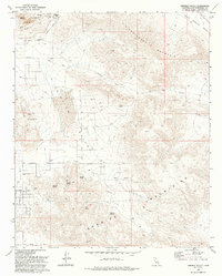 1993 Fairview Valley1993 Print · USGSHigh desert industry and rugged mountain terrain define this San Bernardino County landscape in the 1990s. Researchers can trace the footprint of mining operations at Black Mountain and locate remote water sources like Quail Spring and Amaral Spring.
 - 1996 Map of Rattlesnake Canyon, 1999 Print
 1996 Rattlesnake Canyon1999 Print · USGSThe Bighorn Mountains meet the high desert in the mid-1990s, revealing a landscape of mining claims and vital desert springs. Researchers can trace the Mound Spring Road or locate historic water sources like Viscera Spring and Vaughn Spring.
 - 1996 Map of Butler Peak, 1999 Print
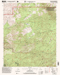 1996 Butler Peak1999 Print · USGSThe San Bernardino high country in the mid-1990s reveals a wilderness of mining claims and rugged peaks. Researchers can trace historic sites like Hawes Ranch, the Balanced Rock Mine, and the high-elevation Butler Peak lookout.
 - 1996 Map of Big Bear City, 1999 Print
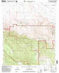
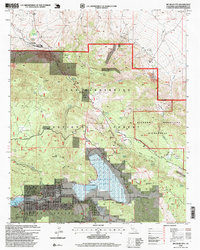 1996 Big Bear City1999 Print · USGSThe San Bernardino Mountains in the late nineties reveal a landscape shaped by mining and outdoor recreation. Researchers can trace the layout of Big Bear City and find historic workings like the Doble Mine and Blackhawk Mine near Baldwin Lake.
 - 1999 Map of Old Woman Springs, 2002 Print
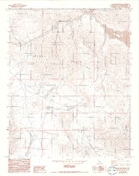
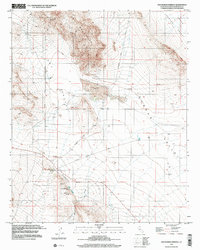 1999 Old Woman Springs2002 Print · USGSThe high-desert ranching and mining country of the Mojave comes into focus during the late 1990s. Genealogists and desert researchers can trace the Old Woman Springs Ranch and mining routes like Bessemer Mine Road.
End of results
Showing maps 1-6 of 6
Frequently asked questions
- What are the different types of historical maps available for Lucerne Valley?
- What is the oldest map of Lucerne Valley?
- Where can I purchase historical maps of Lucerne Valley for my home or office?
- Where can I download high-res historical maps of Lucerne Valley?
- Are there historical topographic maps available for Lucerne Valley?
- Is there historical aerial imagery available for Lucerne Valley?
- Where are historical maps of Lucerne Valley sourced from?