1970s Maps of Lucerne Valley, California
Explore 10 historic maps of Lucerne Valley from the 1970s. These maps offer a rare glimpse into what life looked like during the 1970s — showing old roads, neighborhoods, homes, and landmarks that have changed or disappeared over time.
Whether you're researching your family's past, planning a metal detecting trip, or studying how Lucerne Valley's landscape evolved across the 1970s, these high-resolution maps are a powerful tool for exploring the history of this region.
- Focus on a specific era: All maps on this page are from the 1970s, giving you a focused view of this time period.
- See what’s changed: Compare century-old streets, trails, and buildings to today's modern landscape using overlays and satellite layers.
- Research with precision: Use these maps for genealogy, historical research, land use analysis, or educational projects.
- View, download, or print: Maps are fully viewable online in high resolution, and can be downloaded or printed for your own records.
Start exploring Lucerne Valley's history through authentic maps from the 1970s. This is your window into the past.
Lucerne Valley, CA maps
(10)- 1970 Map of Fairview Valley, 1975 Print
 1970 Fairview Valley1975 Print · USGSThe high desert of San Bernardino County comes into focus in this 1970 survey of industry and terrain. Researchers can trace the industrial layout of the Cement Plant and Red Top Mine or locate historic desert water sources like Isabelle Spring.
 - 1970 Map of Stoddard Well, 1975 Print
 1970 Stoddard Well1975 Print · USGSThe high desert of San Bernardino County was a hub of mineral exploration and transit during the early 1970s. Trace old desert roads and mining claims like the Sidewinder Mine, Early Mine, and the historic water stop at Stoddard Well.2 unique versions available
 - 1971 Map of Cougar Buttes, 1975 Print
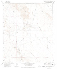
 1971 Cougar Buttes1975 Print · USGSLucerne Valley in the early 1970s shows a fascinating mix of industrial mining and ambitious desert subdivision. Trace family-named roads and mining history at the Old Woman Mine, Silver Reef Mine, and the celestial-themed grid of Comet Road.3 unique versions available
 - 1971 Map of Butler Peak, 1975 Print
 1971 Butler Peak1975 Print · USGSThe San Bernardino high country in the early seventies reveals a landscape shaped by mining, grazing, and mountain recreation. Researchers can locate remote mineral sites like Balanced Rock Mine, the historic Hawes Ranch, and the Pacific Crest National Scenic Trail.2 unique versions available
 - 1971 Map of Fifteenmile Valley, 1975 Print
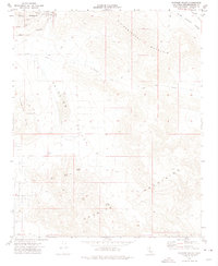
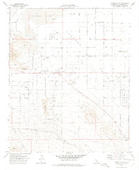
 1971 Fifteenmile Valley1975 Print · USGSThe high desert of San Bernardino County comes into focus during the early seventies as residential grids begin to mesh with the local ranching and rail landscape. Genealogists and historians can trace old homestead routes and industrial markers like the V P Mine, Deadman Point, and the Atchison Topeka and Santa Fe Railway.2 unique versions available
 - 1971 Map of Lucerne Valley, 1975 Print
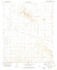
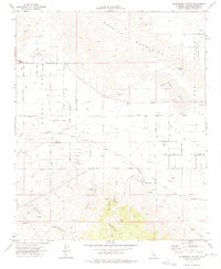
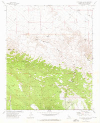
 1971 Lucerne Valley1975 Print · USGSThe High Desert community of Lucerne Valley is captured here in the early seventies as residential grids expanded toward the dry lakebed. Researchers can locate family landmarks like Rabbit Springs, the local Grave, and the southern Atchison Topeka and Santa Fe rail line.3 unique versions available
 - 1971 Map of Big Bear City, 1975 Print
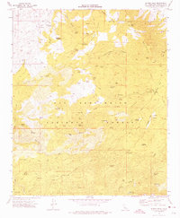
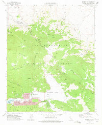 1971 Big Bear City1975 Print · USGSBig Bear City and the high desert transition are captured in the early 1970s as mining and recreation reshaped the San Bernardino Mountains. Genealogists and historians can trace the foundations of Doble, locate the Gold Hill Mine, and see the residential growth of Sugarloaf and Big Bear City.7 unique versions available
 - 1972 Map of Old Woman Springs, 1975 Print
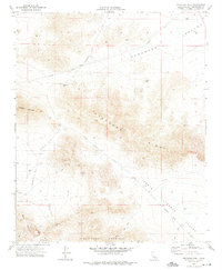
 1972 Old Woman Springs1975 Print · USGSSan Bernardino County ranching and mining life comes into focus in the early seventies. Genealogists and desert historians can trace the foundations of the Old Woman Springs Ranch and the Lafon Ranch, or locate the Green Rock Mine.2 unique versions available
 - 1972 Map of Rattlesnake Canyon, 1976 Print
 1972 Rattlesnake Canyon1976 Print · USGSSan Bernardino's high desert and mountain peaks come alive in this early 1970s survey. Researchers can trace historic mining activity near Rattlesnake Canyon or locate remote water sources like Viscera Springs and Two Hole Spring.4 unique versions available
 - 1977 Map of Newberry Springs, 1993 Print
 1977 Newberry Springs1993 Print · USGSThe Mojave High Desert in the late seventies is shown here as a landscape of railroads and mining. Researchers can trace the legacy of remote camps and transport hubs like Stedman, Ragtown, and the busy Barstow-Daggett Airport.
End of results
Showing maps 1-10 of 10
Frequently asked questions
- What are the different types of historical maps available for Lucerne Valley?
- What is the oldest map of Lucerne Valley?
- Where can I purchase historical maps of Lucerne Valley for my home or office?
- Where can I download high-res historical maps of Lucerne Valley?
- Are there historical topographic maps available for Lucerne Valley?
- Is there historical aerial imagery available for Lucerne Valley?
- Where are historical maps of Lucerne Valley sourced from?