1970s Maps of Needles, California
Explore 5 historic maps of Needles from the 1970s. These maps offer a rare glimpse into what life looked like during the 1970s — showing old roads, neighborhoods, homes, and landmarks that have changed or disappeared over time.
Whether you're researching your family's past, planning a metal detecting trip, or studying how Needles's landscape evolved across the 1970s, these high-resolution maps are a powerful tool for exploring the history of this region.
- Focus on a specific era: All maps on this page are from the 1970s, giving you a focused view of this time period.
- See what’s changed: Compare century-old streets, trails, and buildings to today's modern landscape using overlays and satellite layers.
- Research with precision: Use these maps for genealogy, historical research, land use analysis, or educational projects.
- View, download, or print: Maps are fully viewable online in high resolution, and can be downloaded or printed for your own records.
Start exploring Needles's history through authentic maps from the 1970s. This is your window into the past.
Needles, CA maps
(5)- 1970 Map of Needles SW, 1973 Print
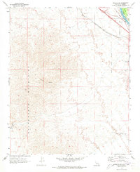 1970 Needles SW1973 Print · USGSThe high desert of San Bernardino County meets the Arizona border in the early 1970s, showcasing the transportation and mining roots of the region. Local researchers can trace the National Old Trails Road and locate remote mining prospects near Shadow Canyon.2 unique versions available
 - 1970 Map of Needles NW, 1973 Print
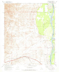 1970 Needles NW1973 Print · USGSThe Colorado River borderlands in the early 1970s reveal a mix of desert ranching and heavy rail infrastructure. Researchers can locate the Soto Ranch, the rail stop at Java, and the Walters Ranch Landing Field along the Mohave Valley floor.2 unique versions available
 - 1970 Map of Needles, 1973 Print
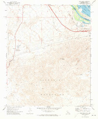
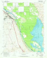 1970 Needles1973 Print · USGSNeedles and the Colorado River corridor are captured here in the early 1970s as the town serves as a vital rail and river junction. Trace the Atchison Topeka and Santa Fe Railroad through the valley or locate early landmarks like Fivemile Landing and the Needles Municipal Airport.4 unique versions available
 - 1971 Map of Monumental Pass, 1973 Print
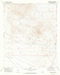 1971 Monumental Pass1973 Print · USGSThe eastern San Bernardino desert comes into focus during the early 1970s, showing a landscape defined by utility lines and mountain crossings. Researchers can trace the path of the Pipeline across the Chemehuevi Valley or locate the remote Prospect and Radio Tower.
 - 1971 Map of Whale Mtn, 1973 Print
 1971 Whale Mtn1973 Print · USGSThe California-Arizona borderlands come into focus in the early seventies, where the Mojave Desert meets the river. Researchers can trace the industrial infrastructure of the South Needles Compressor Station or locate remote mining operations like the Blue Boy Mine.3 unique versions available
End of results
Showing maps 1-5 of 5
Top cities near Needles
- Bullhead City historical maps
- Fort Mohave historical maps
- Mohave Valley historical maps
- Golden Shores historical maps
- Willow Valley historical maps
- Arizona Village historical maps
See more
Top neighborhoods of Needles
Frequently asked questions
- What are the different types of historical maps available for Needles?
- What is the oldest map of Needles?
- Where can I purchase historical maps of Needles for my home or office?
- Where can I download high-res historical maps of Needles?
- Are there historical topographic maps available for Needles?
- Is there historical aerial imagery available for Needles?
- Where are historical maps of Needles sourced from?