1900s (20th Century) Maps of San Diego County, California
Explore 308 historic maps of San Diego County from the 1900s (20th Century). These maps offer a rare glimpse into what life looked like during the 1900s — showing old roads, neighborhoods, homes, and landmarks that have changed or disappeared over time.
Whether you're researching your family's past, planning a metal detecting trip, or studying how San Diego County's landscape evolved across the 1900s, these high-resolution maps are a powerful tool for exploring the history of this region.
- Focus on a specific era: All maps on this page are from the 1900s, giving you a focused view of this time period.
- See what’s changed: Compare century-old streets, trails, and buildings to today's modern landscape using overlays and satellite layers.
- Research with precision: Use these maps for genealogy, historical research, land use analysis, or educational projects.
- View, download, or print: Maps are fully viewable online in high resolution, and can be downloaded or printed for your own records.
Start exploring San Diego County's history through authentic maps from the 1900s. This is your window into the past.
San Diego County, CA maps
(308)- 1901 Map of Southern California Sheet No. 1
 1901 Southern California Sheet No. 11901 Print · USGSGreater Los Angeles at the dawn of the twentieth century is a landscape of growing citrus towns and a burgeoning rail network. Genealogists and historians can trace the early gridded streets of Hollywood and Pasadena or locate landmarks like Bear Lake and the Cahuilla Indian Reservation.6 unique versions available
 - 1901 Map of Elcajon
 1901 Elcajon1901 Print · USGSSan Diego's eastern valleys are shown at the turn of the century as agriculture and water infrastructure began to reshape the landscape. Trace the path of the San Diego Flume and its tunnels or the rail line serving Foster, Lakeside, and Elcajon.
 - 1901 Map of Elsinore
 1901 Elsinore1901 Print · USGSRiverside and the Alessandro Valley are shown here during a peak of early mining and rail expansion. Genealogists and historians can trace the Southern California RR through Perris or locate the Alberhill Coal Mine and Indian School.8 unique versions available
 - 1901 Map of Escondido
 1901 Escondido1901 Print · USGSInland San Diego County was a landscape of citrus groves and cattle ranges at the dawn of the twentieth century. Genealogists can trace family footprints in early settlements like Escondido and Bernardo, or follow the rail path of the Southern California R. R. Escondido Branch.6 unique versions available
 - 1901 Map of Oceanside
 1901 Oceanside1901 Print · USGSCoastal San Diego County is captured at the turn of the century, showing the early rail-driven growth of the shoreline. Genealogists and historians can trace the foundations of Oceanside, Carlsbad, and the San Luis Rey Mission along the Surf Line rail route.8 unique versions available
 - 1901 Map of San Luis Rey
 1901 San Luis Rey1901 Print · USGSNorthern San Diego County is shown at the turn of the century as a landscape of sprawling ranchos, early coastal railroads, and secluded mountain valleys. Researchers can trace the routes of the California Southern RR or locate early settlements like De Luz, Pala, and the Temecula Indian Res.8 unique versions available
 - 1902 Map of Capistrano
 1902 Capistrano1902 Print · USGSThe Orange County coast and its expansive ranchos are captured here just before the twentieth century's rapid changes. Researchers can trace the early Southern California rail line past Capistrano and explore old canyon routes like Cristianitos.4 unique versions available
 - 1902 Map of Corona
 1902 Corona1902 Print · USGSThe Orange County and Riverside borderlands at the start of the 1900s show an era of rapid rail expansion and water engineering. Researchers can trace the early footprints of Anaheim and Orange or find vanished industry at the Santiago Coal Mine.7 unique versions available
 - 1903 Map of Cuyamaca
 1903 Cuyamaca1903 Print · USGSInland San Diego County at the turn of the century reveals a landscape defined by new water infrastructure and rail lines. Genealogists and historians can trace early settlements like Lakeside, Dulzura, and the remote Honey Springs Ranch along the international border.6 unique versions available
 - 1903 Map of La Jolla
 1903 La Jolla1903 Print · USGSCoastal San Diego at the turn of the century shows a landscape of deep canyons and emerging rail towns before the rapid expansion of the modern city. Genealogists and historians can trace early settlements like Old Town, Pacific Beach, and the inland community of Poway along the Southern California R. R.9 unique versions available
 - 1903 Map of Elcajon
 1903 Elcajon1903 Print · USGSSan Diego's interior transitions from rail-linked valleys to high reservations at the turn of the century. Trace the path of the San Diego Flume and find vanished railroad stops like Foster and Moreno alongside the growing Elcajon Valley.5 unique versions available
 - 1903 Map of Ramona
 1903 Ramona1903 Print · USGSSan Diego County's high country and interior valleys are captured here at the start of the twentieth century, during a time of mountain ranching and early gold mining. Researchers can trace the early footprints of Julian, Ramona, and Mesa Grande, alongside the boundaries of the San Jacinto Forest Reserve.6 unique versions available
 - 1904 Map of Indio
 1904 Indio1904 Print · USGSThe Conchilla Desert and San Jacinto Mountains appear here at the turn of the century as the Southern Pacific rail corridor began to transform the valley. Trace early settlements and tribal lands like Cabezon Indian Res., Figtree John, and the Asbestos Mine.7 unique versions available
 - 1904 Map of San Diego
 1904 San Diego1904 Print · USGSSan Diego and its harbor are captured here in the early twentieth century, showing a coastal landscape defined by ranchos and early rail lines. Researchers can trace the development of National City, locate the original grounds of Ft. Rosecrans, and see the early layout of Chulavista.9 unique versions available
 - 1904 Map of Southern California Sheet No. 2
 1904 Southern California Sheet No. 21904 Print · USGSSouthern California during the early 1900s shows the transition from vast ranchos to coastal rail towns. Genealogists and researchers can trace the Southern California R.R. through Oceanside, explore old land grants like Mission Viejo, and locate early settlements from Fallbrook to Julian.5 unique versions available
 - 1904 Map of Southern California Sheet No. 1, 1905 Print
 1904 Southern California Sheet No. 11905 Print · USGSSouthern California at the dawn of the twentieth century shows a landscape of citrus groves and coastal towns connected by rail. Genealogists and historians can trace early settlements like San Juan Capistrano, find remote sites like the Rose Mine, and study the original water systems of the Santa Ana River.2 unique versions available
 - 1906 Map of Capistrano, 1921 Print
 1906 Capistrano1921 Print · USGSThe Orange and San Diego county borderlands appear here just before the turn of the century, when large land grants still defined the coast. You can trace the Southern California railroad line through San Juan down to the remote shores of San Onofre.
 - 1930 Map of La Jolla, 1955 Print
 1930 La Jolla1955 Print · USGSCoastal San Diego was undergoing a rapid transformation in the early 1930s as military footprints and rail lines reshaped the landscape. Researchers can trace the early development of La Jolla and Pacific Beach or locate old sites like Camp Kearney and Merton.2 unique versions available
 - 1930 Map of San Diego, 1960 Print
 1930 San Diego1960 Print · USGSSan Diego and its southern coastal towns appear here at the dawn of the aviation era, showing a landscape defined by naval expansion and ranchos. Trace the early layout of Lindbergh Airport, the military works at Point Loma, and the rails connecting Chula Vista to the United States Mexico border.
 - 1931 Map of Vallecito
 1931 Vallecito1931 Print · USGSThe Colorado Desert and its surrounding ranges are mapped here in the early thirties, showcasing a landscape defined by scarce water and massive terrain. Genealogists can trace isolated desert outposts like Fig Tree John and Agua Dulce or the original footprint of Borego Springs.
 - 1931 Map of Carrizo, 1938 Print
 1931 Carrizo1938 Print · USGSBorderland life in the 1930s is defined by remote ranching outposts and vital desert springs along the international line. Trace old family sites and water sources like Campo P.O., Agua Caliente Hot Springs, and Laguna Ranch.
 - 1939 Map of El Cajon, 1955 Print
 1939 El Cajon1955 Print · USGSEl Cajon and the San Diego River valleys appear in the late thirties as a network of citrus groves, cattle ranches, and tribal lands. Genealogists and researchers can trace the early footprints of Santee, the Edgemoor County Farm, and the Daly Mine.2 unique versions available
 - 1939 Map of Campo, 1956 Print
 1939 Campo1956 Print · USGSSouthern San Diego County's high desert and mountain ranchlands are documented here just before the mid-century, featuring the winding international border. Researchers can trace the path of the San Diego and Arizona Eastern railroad through Campo and locate historic sites like Mountain Empire Sch or the U S Customs office.
 - 1939 Map of Warner Springs, 1956 Print
 1939 Warner Springs1956 Print · USGSIn the high backcountry of San Diego and Riverside counties just before the 1940s, this area shows a landscape of cattle ranges and mountain outposts. Genealogists and researchers can trace early settlements and trails including Holcomb Village, Warner Springs, and the historic Deadman Hole spring.
 - 1939 Map of Santa Ysabel, 1956 Print
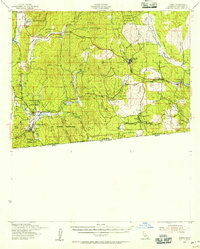
 1939 Santa Ysabel1956 Print · USGSSan Diego County's high country is captured here during the late 1930s, showing a transition from ranching valleys to mining canyons. Trace family history at Warner Ranch, explore the gold mines near Banner, or locate the Volcan Indian Sch.2 unique versions available
Showing maps 1-25 of 308
Top cities of San Diego County
- San Diego historical maps
- Chula Vista historical maps
- Oceanside historical maps
- Escondido historical maps
- Carlsbad historical maps
- El Cajon historical maps
See more
Frequently asked questions
- What are the different types of historical maps available for San Diego County?
- What is the oldest map of San Diego County?
- Where can I purchase historical maps of San Diego County for my home or office?
- Where can I download high-res historical maps of San Diego County?
- Are there historical topographic maps available for San Diego County?
- Is there historical aerial imagery available for San Diego County?
- Where are historical maps of San Diego County sourced from?