1940s Maps of San Diego County, California
Explore 84 historic maps of San Diego County from the 1940s. These maps offer a rare glimpse into what life looked like during the 1940s — showing old roads, neighborhoods, homes, and landmarks that have changed or disappeared over time.
Whether you're researching your family's past, planning a metal detecting trip, or studying how San Diego County's landscape evolved across the 1940s, these high-resolution maps are a powerful tool for exploring the history of this region.
- Focus on a specific era: All maps on this page are from the 1940s, giving you a focused view of this time period.
- See what’s changed: Compare century-old streets, trails, and buildings to today's modern landscape using overlays and satellite layers.
- Research with precision: Use these maps for genealogy, historical research, land use analysis, or educational projects.
- View, download, or print: Maps are fully viewable online in high resolution, and can be downloaded or printed for your own records.
Start exploring San Diego County's history through authentic maps from the 1940s. This is your window into the past.
San Diego County, CA maps
(84)- 1941 Map of Clark Lake, 1956 Print
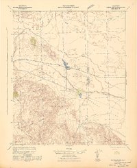
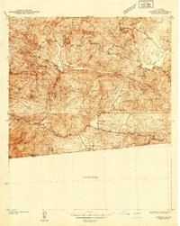
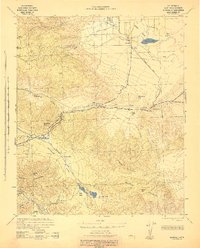
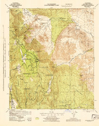
 1941 Clark Lake1956 Print · USGSBorrego Valley and the Santa Rosa Mountains are captured here in the early 1940s, showing a desert landscape before modern development. You can trace the early ranching history of the region through markers like Rancho De Anza, Brinniger Ranch, and the Anza Trail.
 - 1941 Map of Margarita Peak, 1961 Print
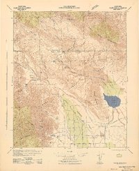
 1941 Margarita Peak1961 Print · USGSSan Diego's coastal ranch lands and backcountry peaks are captured here in the early forties, just before the landscape shifted toward major military use. Researchers can trace historic family estates like Rancho Santa Margarita and old rail stops along the AT&SF RR near De Luz Station.
 - 1942 Map of Poway Valley
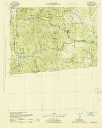
 1942 Poway Valley1942 Print · USGSCoastal San Diego's interior valleys and ranch lands are shown in the early 1940s as rural communities began to coalesce. Genealogists and researchers can trace the early layout of Poway, the site of Pomerado Sch, and the Emergency Landing Field at Scripps Ranch.2 unique versions available
 - 1942 Map of Barrel Spring
 1942 Barrel Spring1942 Print · USGSThe Colorado Desert at the start of the 1940s reveals a landscape of industrial outposts and early parklands. Researchers can trace the Pacific Portland Cement Railroad leading to a remote Gypsum Mine or locate early settlements like Ocotillo and Little Borrego.2 unique versions available
 - 1942 Map of Lake Elsinore
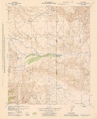
 1942 Lake Elsinore1942 Print · USGSIn the early war years, this area of Riverside County remained a mix of mining outposts, large ranchos, and lakefront towns. Genealogists and historians can trace family properties like Lyne Ranch and Baker Ranch or follow the old Santa Fe Railroad past Terra Cotta and Willard.
 - 1942 Map of Agua Dulce
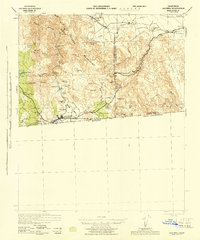
 1942 Agua Dulce1942 Print · USGSThe Colorado Desert at the start of World War II reveals a landscape of high peaks and below-sea-level basins. Trace early desert life through the Oasis Sch, the remote Seventeen-Palms oasis, and the shoreline at Fish Springs.
 - 1942 Map of Clark Lake
 1942 Clark Lake1942 Print · USGSSan Diego and Riverside Counties were still largely defined by remote ranching and desert springs during the early 1940s. Genealogists and historians can trace the foundations of the valley at Brinniger Ranch, the Borrego Sch, and the Old Santa Rosa Indian Ruins.2 unique versions available
 - 1942 Map of Margarita Peak
 1942 Margarita Peak1942 Print · USGSDuring the early years of World War II, this region of San Diego County remained a landscape of vast ranchos and scattered citrus groves. Genealogists can trace family holdings like Doville Ranch and community hubs including Deluz PO and the Horno Canyon CCC Camp.
 - 1942 Map of La Mesa
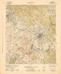
 1942 La Mesa1942 Print · USGSSan Diego and La Mesa appear here in the early 1940s, showing a landscape of growing residential neighborhoods and rugged canyon terrain. Genealogists and historians can trace numerous early schools like Hoover High Sch, the grounds of State College, and the historic Mission San Diego.
 - 1942 Map of San Juan Capistrano
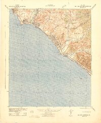 1942 San Juan Capistrano1942 Print · USGSCoastal Orange and San Diego counties are captured here in the early 1940s as the classic California beach towns began to take shape. Genealogists and local historians can trace early settlements and transit hubs from San Juan Capistrano to the Villa Auto Camp and the CCC Camp near San Clemente.
 - 1942 Map of Temecula
 1942 Temecula1942 Print · USGSNorthern San Diego County and southern Riverside County are mapped here in the early 1940s, showing a rural landscape of canyons and ranch lands. Genealogists can trace family holdings at San Luis Rey Rancho or find early schools like Lilac Valley Sch.
 - 1942 Map of Oceanside
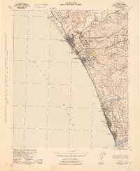 1942 Oceanside1942 Print · USGSNorthern San Diego County coastal life during the early 1940s is shown here along the Pacific shoreline. Researchers can trace the original footprints of Carlsbad, Encinitas, and Leucadia, or find family landmarks like Libby Sch and the San Luis Rey Mission.
 - 1942 Map of Potrero
 1942 Potrero1942 Print · USGSThe southern California borderlands come into focus during the early 1940s, showing the complex terrain of the Cleveland National Forest. Genealogists and historians can trace rural schoolhouses like Potrero Sch, the path of the San Diego & Arizona Eastern RR, and the border crossing at Tecate.
 - 1942 Map of Escondido
 1942 Escondido1942 Print · USGSNorthern San Diego County is captured here in the early 1940s, showing the inland citrus and ranching valleys before major development. Researchers can locate early schoolhouses like Rincon Sch and trace the original Escondido Branch rail line.
 - 1942 Map of Point Loma
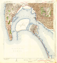 1942 Point Loma1942 Print · USGSSan Diego and the peninsula appear here in the early 1940s, showcasing a landscape of naval installations and coastal neighborhoods. Trace family roots and local history through Roseville Point Loma PO, Tent City, and the Union Sta rail hub.2 unique versions available
 - 1942 Map of El Cajon
 1942 El Cajon1942 Print · USGSInland San Diego County unfolds in the early 1940s, showing a landscape of working ranches and river valleys before modern development. Genealogists and historians can trace family-named lands like Peale Ranch and early institutions such as Dehesa Sch and the Daky Mine.
 - 1942 Map of Santiago Peak, 1943 Print
 1942 Santiago Peak1943 Print · USGSOrange County and the inland canyons appear here in the early 1940s, showing a landscape of small settlements and rugged mountain reaches. Genealogists and local historians can trace early holdings near San Juan Capistrano, the station at El Toro, and mountain landmarks like Modjeska.3 unique versions available
 - 1942 Map of Borego, 1943 Print
 1942 Borego1943 Print · USGSThe Anza-Borrego desert region during the early Forties reveals a landscape of pioneer trails and early tourism. Trace the Old Overland Stage Route past Las Arena Ranch or locate early outposts like Desert Lodge and Yaqui Well.2 unique versions available
 - 1942 Map of Campo, 1944 Print
 1942 Campo1944 Print · USGSThe international border and the winding route of the San Diego and Arizona Eastern railroad define this mountain region during the early 1940s. Genealogists and local historians can trace family locations at Castle Rock Ranch, Boulder Oaks, and the Hipass Station rail stop.
 - 1942 Map of Carrizo Mtn, 1944 Print
 1942 Carrizo Mtn1944 Print · USGSThe high desert at the San Diego and Imperial County border comes alive in this wartime survey of the early 1940s. Follow the Old Overland Stage Route to the Old Carrizo Stage Station or locate the site of Prehistoric Animal Tracks.4 unique versions available
 - 1942 Map of Jacumba, 1944 Print
 1942 Jacumba1944 Print · USGSThe high desert borderlands come alive in the 1940s as the railroad traverses the mountains into Imperial County. Researchers can trace the path of the San Diego and Arizona Eastern through Jacumba Hot Springs to remote sidings and desert claims like Mica Gem Mine.
 - 1942 Map of Cuyapaipe, 1944 Print
 1942 Cuyapaipe1944 Print · USGSSan Diego County high country and desert transition during the early years of the war. Genealogists can trace family holdings like Crouch Ranch and Thing Ranch or locate the historic Overland Stage Route.3 unique versions available
 - 1942 Map of Ramona, 1947 Print
 1942 Ramona1947 Print · USGSNorthern San Diego County ranching and forest lands are detailed here during the mid-1940s. Local researchers can trace family-named sites like Silvano Ranch or explore the boundaries of the San Pasqual Indian Reservation and Mesa Grande.2 unique versions available
 - 1942 Map of Cuyamaca Peak, 1954 Print
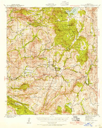 1942 Cuyamaca Peak1954 Print · USGSSan Diego County’s backcountry comes alive in the early 1940s, showing the high mountain ranching and reservation lands before modern development. Researchers can trace the footprints of Anahuac Sch, Burney Ranch, and the Viejas Indian Reservation.2 unique versions available
 - 1943 Map of Santa Ysabel
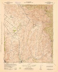
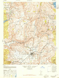
 1943 Santa Ysabel1943 Print · USGSSan Diego County's high country is captured here during the early war years, showing a landscape of tribal reservations, cattle ranches, and mountain mining. Trace the history of remote outposts like Julian, the Santa Ysabel Chapel, and the Friday Mine.
Showing maps 1-25 of 84
Top cities of San Diego County
- San Diego historical maps
- Chula Vista historical maps
- Oceanside historical maps
- Escondido historical maps
- Carlsbad historical maps
- El Cajon historical maps
See more
Frequently asked questions
- What are the different types of historical maps available for San Diego County?
- What is the oldest map of San Diego County?
- Where can I purchase historical maps of San Diego County for my home or office?
- Where can I download high-res historical maps of San Diego County?
- Are there historical topographic maps available for San Diego County?
- Is there historical aerial imagery available for San Diego County?
- Where are historical maps of San Diego County sourced from?